 Old Cumbria Gazetteer
 |
 |
|
| Lancaster Sands | ||
| Leven Sands | ||
| Kent Sands | ||
| site name:- | Morecambe Bay | |
| locality type:- | sands | |
| locality type:- | foreshore | |
| 10Km square:- | SD47 (etc) | |
| 1Km square:- | SD4070 | |
| 10Km square:- | SD47 | |
| 10Km square:- | SD46 | |
|
|
||
| evidence:- | old map:- Saxton 1579 |
|
| source data:- | Map, hand coloured engraving, Westmorlandiae et Cumberlandiae Comitatus ie Westmorland
and Cumberland, scale about 5 miles to 1 inch, by Christopher Saxton, London, engraved
by Augustinus Ryther, 1576, published 1579-1645.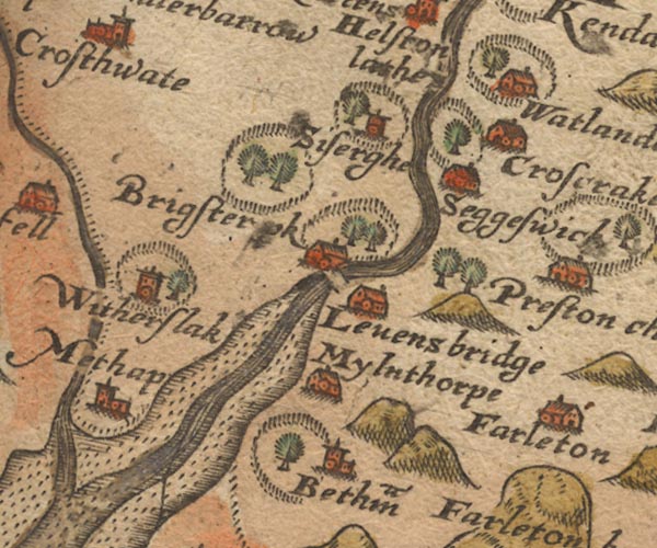 Sax9SD48.jpg  Sax9SD37.jpg item:- private collection : 2 Image © see bottom of page |
|
|
|
||
| evidence:- | old map:- Mercator 1595 (edn?) placename:- |
|
| source data:- | Map, hand coloured engraving, Westmorlandia, Lancastria, Cestria
etc, ie Westmorland, Lancashire, Cheshire etc, scale about 10.5
miles to 1 inch, by Gerard Mercator, Duisberg, Germany, 1595,
edition 1613-16.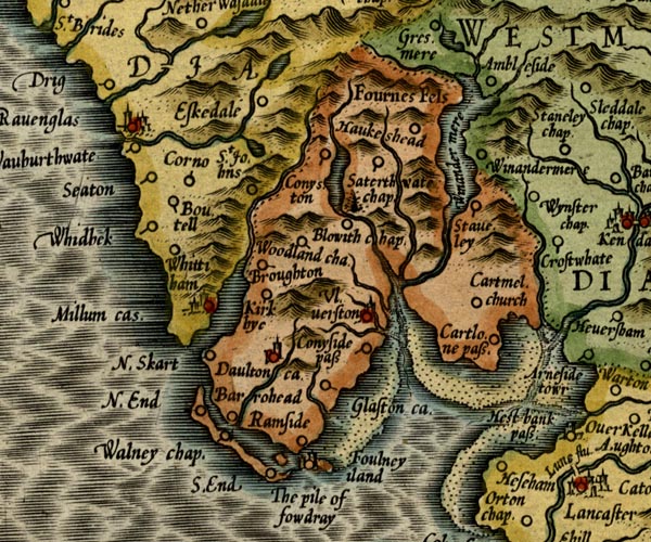 MER5LanA.jpg "" foreshore sands item:- Armitt Library : 2008.14.3 Image © see bottom of page |
|
|
|
||
| evidence:- | old map:- Speed 1611 (Wmd) placename:- Ken Sandes |
|
| source data:- | Map, hand coloured engraving, The Countie Westmorland and
Kendale the Cheif Towne, scale about 2.5 miles to 1 inch, by
John Speed, 1610, published by George Humble, Popes Head Alley,
London, 1611-12. SP14SD37.jpg "Ken Sandes" sands 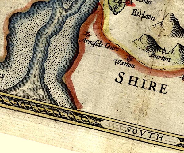 SP14SD47.jpg sands item:- Armitt Library : 2008.14.5 Image © see bottom of page |
|
|
|
||
| evidence:- | old map:- Ogilby 1675 (plate 38) |
|
| source data:- | Road strip map, hand coloured engraving, continuation of the
Road from London to Carlisle, scale about 1 inch to 1 mile, by
John Ogilby, London, 1675.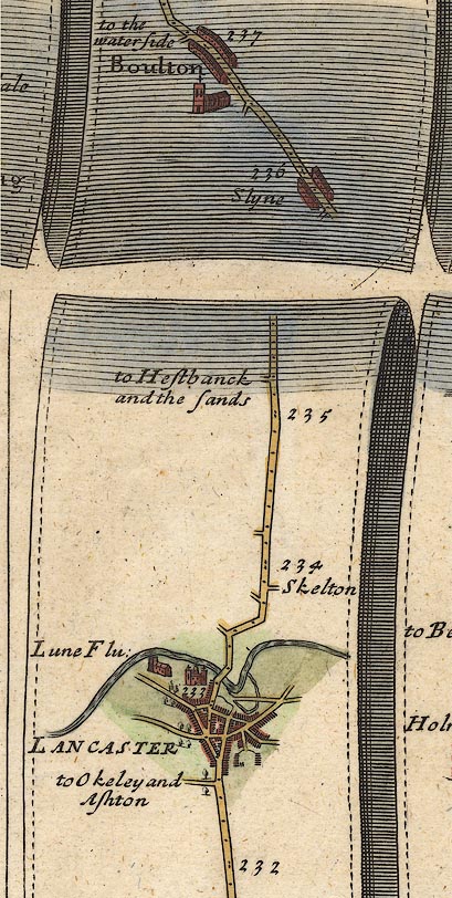 OG38m232.jpg In mile 235, Lancashire. Turning left:- "to Hestbanck and the sands" item:- JandMN : 21 Image © see bottom of page |
|
|
|
||
| evidence:- | old map:- Sanson 1679 placename:- Ken Sandes |
|
| source data:- | Map, hand coloured engraving, Ancien Royaume de Northumberland
aujourdhuy Provinces de Nort, ie the Ancient Kingdom of
Northumberland or the Northern Provinces, scale about 9.5 miles
to 1 inch, by Nicholas Sanson, Paris, France, 1679. click to enlarge click to enlargeSAN2Cm.jpg "Ken Sandes" foreshore sands item:- Dove Cottage : 2007.38.15 Image © see bottom of page |
|
|
|
||
| evidence:- | old map:- Seller 1694 (Wmd) placename:- Ken Sand |
|
| source data:- | Map, hand coloured engraving, Westmorland, scale about 8 miles
to 1 inch, by John Seller, 1694. click to enlarge click to enlargeSEL7.jpg "Ken Sand" foreshore sands item:- Dove Cottage : 2007.38.87 Image © see bottom of page |
|
|
|
||
| evidence:- | old map:- Morden 1695 (Wmd) |
|
| source data:- | Map, hand coloured engraving, Westmorland, scale about 2.5 miles to 1 inch, by Robert
Morden, published by Abel Swale, the Unicorn, St Paul's Churchyard, Awnsham, and John
Churchill, the Black Swan, Paternoster Row, London, 1695.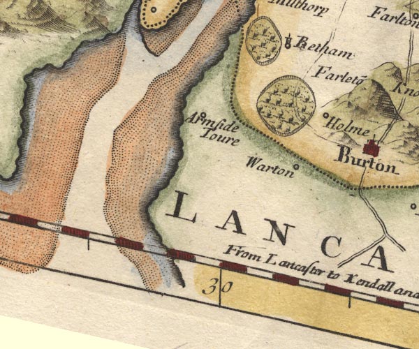 MD10SD47.jpg item:- JandMN : 24 Image © see bottom of page |
|
|
|
||
| evidence:- | descriptive text:- West 1778 (11th edn 1821) |
|
| source data:- | Guide book, A Guide to the Lakes, by Thomas West, published by
William Pennington, Kendal, Cumbria once Westmorland, and in
London, 1778 to 1821. goto source goto sourceAddendum; Mr Gray's Journal, 1769 Page 217:- "..." "Oct. 11. I crossed the river [Lune, from Lancaster] and walked over a peninsula three miles, to the village of Poulton, which stands on the beach. An old fisherman mending his nets (while I enquired about the danger of passing those sands) told me, in his dialect, a moving story, how a brother of the trade, a Cockler, as he styled him, driving a little cart with two daughters (women grown) in it, and his wife on horseback following, set out one day to cross the seven mile sands, as they had frequently been used to do; (for nobody in the village knew them better than the old man did) when they were about half-way over, a thick fog rose, and as they advanced they found the water much deeper than they expected; the old man was puzzled; he stopped, and said he would go a little way to find some mark he was acquainted with; they staid a while for him, but in vain; they called aloud, but no reply; at last the young woman pressed the mother to think where they were, and go on; she would not leave the place; she wandered about forlorn and amazed; she would not quit her horse and get into the cart with them; they determined after much time wasted, to turn back, and give themselves up to the guidance of their horses. The old woman was soon washed off, and perished; the poor girls clung close to their cart, and" goto sourcePage 218:- "the horse, sometimes wading and sometimes swimming, brought them back to land alive, but senseless with terror and distress, and unable for many days to give any account of themselves. The bodies of their parents were found the next ebb: that of the father a very few paces distant from the spot where he had left them." goto sourceMrs Radcliffe's Ride over Skiddaw, 1794 Page 308:- "[on Skiddaw] ... beyond all the fells of the lakes, Lancaster Sands extended to the faintly-seen waters of the sea. ..." |
|
|
|
||
| evidence:- | old map:- West 1784 map placename:- Lancaster Sands |
|
| source data:- | Map, hand coloured engraving, A Map of the Lakes in Cumberland,
Westmorland and Lancashire, scale about 3.5 miles to 1 inch,
engraved by Paas, 53 Holborn, London, about 1784. Ws02SD37.jpg 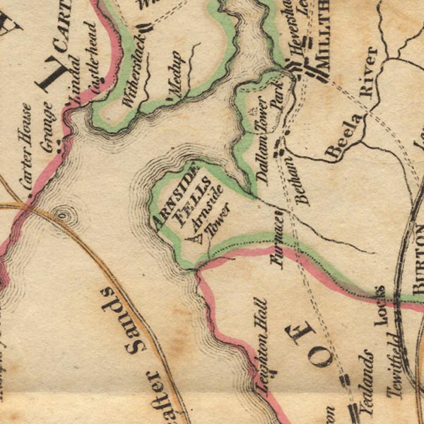 Ws02SD47.jpg  Ws02SD46.jpg item:- Armitt Library : A1221.1 Image © see bottom of page |
|
|
|
||
| evidence:- | old print:- Middiman 1784-92 placename:- Lancaster Sands |
|
| source data:- | Print, uncoloured engraving, View near Lancaster Sands, Lancashire, drawn by F Wheatly,
engraved and published by Samuel Middiman, 3 Grafton Street, Tottenham Court Road,
London, 1787.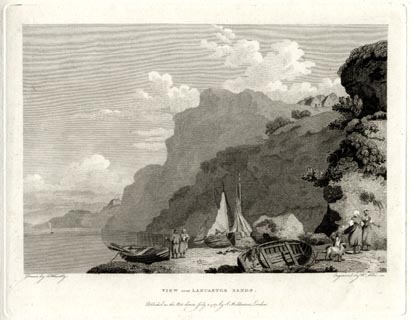 click to enlarge click to enlargeMM0802.jpg "Drawn by F. Wheatly. / Engrav'd by S. Middiman. / VIEW near LANCASTER SANDS. / Publish'd as the Act directs, July 2. 1787, by S. Middiman, London." Accompanying text:- "PLATE XXX." "VIEW near LANCASTER SANDS." "THE Ride over Lancaster Sands, which is about eight Miles, has always been considered as dangerous, but it is now less so than formerly, the Sands being more firm; and, in Company with the Guides who conduct Travellers over, at stated Hours, few Accidents happen." "A Design has been in Contemplation to enclose and improve these Sands, by turning the Course of the River Ken, and others of less Note that fall into the Sea, and cause them to join the River Lune, near Lancaster: Should this Plan be carried into Execution, the large Quantity of Water, obrtained by Means of the intended Canal, would be of the greatest Advantage to the Projectors; and likewise render the Passage to other Ports more safe and commodious." item:- Armitt Library : A6865.2 Image © see bottom of page |
|
|
|
||
| evidence:- | old text:- Camden 1789 placename:- Kentsand |
|
| source data:- | Book, Britannia, or A Chorographical Description of the Flourishing Kingdoms of England,
Scotland, and Ireland, by William Camden, 1586, translated from the 1607 Latin edition
by Richard Gough, published London, 1789. goto source Page 131:- "... Forness ... the shore here running out a great way to the west, the sea, as if enraged at it, lashes it more furiously, and, in high tides. has even devoured the shore, and made three large bays, viz. Kentsand, into which the river Ken empties itself, Levensand and Duddensand, between which the land projects ..." |
|
|
|
||
| evidence:- | old text:- Gents Mag item:- zoology; bird; geology; fossil |
|
| source data:- | Magazine, The Gentleman's Magazine or Monthly Intelligencer or
Historical Chronicle, published by Edward Cave under the
pseudonym Sylvanus Urban, and by other publishers, London,
monthly from 1731 to 1922. goto source Gentleman's Magazine 1794 p.326 "..." "August 2. In pursuance of our last night's resolution, we were on the sands soon after five in the morning. The days was fine, and we determined to follow the shore in order to pick up what curiosities might happen to fall in our way. But it soon appeared that our journey had not been well timed; for, the tides were neap, and the gulls had cleared the deserted channel of the greatest part of the marine animals that are found in it at the time of spring-floods." "These sands are skirted on both sides with calcareous rocks; those on the East side, which bound the shore we examined, are frequently high and naked, and run in a zigzag line; their direction is nearly from North to South as far as Arnside, but afterwards it inclines considerable to the East, whiile the opposite coast continues in the former course, or nearly so; thus the width of the channel is gradually enlarged. The strata are for the most part well formed; but the rocks are, in some places South-east of Arnside, composed of mis-shapen masses, not at all stratified. This lofty bank of limestone abounds with petrifactions, principally of Lithophyta; but the petrified valves of a species of Pinna are sometimes found in it, as well as those of the Cardium Edule and other bivalves. The joints of the strata are in some places stained with a red substance, proceeding from the blood-stone which they contain. This mineral contains much oxyd of iron; its colour is reddish brown; its specific gravity 4.992; one surface is generally convex, the other is less, and concave; the sides are for the most part marked with converging fibres. Another uncommon fossil is found here, the Stirium Marmoreum of Linnaeus, or fibrous limestone; its specific gravity is 2.728; fire converts it into lime; it disolves in the vitriolic, marine, and nitrous acids, and contains carbonic acid gas. We heard that variety of the Motacilla Trochitus, called in Westmorland a Strawsmear, singing in a woody declivity close to the beach, after the same bird had been silent for more than three weeks in the interrior part of the country. It weighs 61/4dwts. The bill is slender, nearly equal; the tongue" |
|
|
|
||
| evidence:- | old text:- Gents Mag 1794 |
|
| source data:- | goto source Gentleman's Magazine 1794 p.327 "notched at the end; the nostrils oval; upper mandible, head, and back, of a mouse-colour tinged with yellow; a light yellow line between each eye and the corresponding nostril; wings of the same colour with the back, except that the inner web of each quill is marked with a yellow margin; tail long, consisting of eleven equal feathers of the same colour with the back; under mandible brownish; throat and breast white; thighs yellow; legs brownish; nails mouse-coloured; under-side of the feet a deep yellow, as is the inside of the bill. It appears here after the middle of April. Its song consists of a succession of distinct loud notes gradually decreasing in acuteness. It frequents hedges, shrubberies, and such-like places. It builds a nest of straws lined with hair, resembling that of the white-throat, and lays generally five eggs of a dirty white colour, marked at the thicker end with numerous dark-brown oval spots. the bird here described can be no other than the Scotch warbler of the "British Zoology;" though the author denies it to be a separate species, in his "Arctic Zoology," on the authority of a Swedish correspondent. We found the Cardium Edule on the sands below Arnside point; and the Fucus Filum, which is brought hither by the tide. The rocks are covered with the Mytilus Edulis, Turbo Littoreus, and Lepas Balanoides; they are also clad with the Fucus Vesiculosus and F. Canaliculatus. The Gulls, which were here numerous, conisted of the three following species, Larus Canus, L. ridibundus, and Winter-gull. Linnaeus makes this a variety of the Larus Canus; and Berkenhour supposes it to be the young of the same; but one was domesticated in this country, and kept in a garden for four years without changing its distinguishing marks; it ought, therefore, to be considered as a distinct species." "The rare plants that grow in the salt ditches on the marsh, the stony beach, and limestone rocks, may be thus enumerated: Apium Graveolens, Auriplex Littoralis, Cochlearia Danica, Triglochin Maritimum, Triticum Junceum, PLantage Coronapus, Atropa Belladona, Chelidonium Glaucium, Arenaria Tenuifolia, Polygonum Aviculare marinum, Roas Arvensis, Crataegus Aria, Conyza Squarosa, Parietaria Officinalis." "After following the beach about three miles beyond Arnside, we discovered the Oniscus*.........icus among the loose stones near low-water mark. This insect has not yet found a place in the British catalogue. It runs quickly, in which it differs from Oniscus Assellus as well as in the structure of its tail." "This was the end of our excursions; for we returned leaving the beach and keeping more on the sands, which were well inhabited by the Lumbricus Marinus. We also picked up the Tellina Carnaria, Medusa Aurita, and the Alcyonium Bursa. The surface of our road was ruffled here and there, so as to as to resemble the knap on frized cloth. This appearance is occasioned by a minute shrimp, the Canas Linearis, multitudes of which bore the sand perpendicularly, each forming for its own use a long narrow cell. It was well observed by my friend at the time, that, if a portion of sand so perforated should happen to be converted into stone, it would form a tubiporus every way like that in the neighbouring rocks, the slenderness of its tubes excepted. The remark was ingenius, and perhaps not very inconsistent with the operations of Nature; for, though the process of petrifaction is unknown, it is highly probable, nay almost demonstrable, that the calcareous strata occupying a vast extent of this country were originally loose sand mixed with marine bodies, just as it appears to be at this day in the capacious channel we have been exploring. The remaining part of our route lay through places already descibed; and the few new observations that occured do not seem worthy of a place in this narrative." "Yours, *c." "X. Z." |
|
|
|
||
| evidence:- | descriptive text:- Baker 1802 placename:- Lancaster Sands |
|
| source data:- | Perspective road map with sections in Lancashire, Westmorland,
and Cumberland, by J Baker, London 1802. pp.25-26:- "..." "Lancaster Sands first passed in this way are 5 miles in breadth, for which a guide should be taken from Hest Bank, ..." |
|
|
|
||
| evidence:- | old map:- Laurie and Whittle 1806 placename:- Lancaster Sands |
|
| source data:- | Road map, Completion of the Roads to the Lakes, scale about 10
miles to 1 inch, by Nathaniel Coltman? 1806, published by Robert
H Laurie, 53 Fleet Street, London, 1834. click to enlarge click to enlargeLw18.jpg "Lancaster Sands / Lancaster Sands may be crossed when the tide is out." sands in estuary item:- private collection : 18.18 Image © see bottom of page |
|
|
|
||
| evidence:- | old map:- Otley 1818 placename:- Lancaster Sands |
|
| source data:- | Map, uncoloured engraving, The District of the Lakes,
Cumberland, Westmorland, and Lancashire, scale about 4 miles to
1 inch, by Jonathan Otley, 1818, engraved by J and G Menzies,
Edinburgh, Scotland, published by Jonathan Otley, Keswick,
Cumberland, et al, 1833.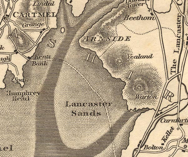 OT02SD47.jpg item:- JandMN : 48.1 Image © see bottom of page |
|
|
|
||
| evidence:- | descriptive text:- Ford 1839 (3rd edn 1843) placename:- Lancaster Sands |
|
| source data:- | Guide book, A Description of Scenery in the Lake District, by
Rev William Ford, published by Charles Thurnam, Carlisle, by W
Edwards, 12 Ave Maria Lane, Charles Tilt, Fleet Street, William
Smith, 113 Fleet Street, London, by Currie and Bowman,
Newcastle, by Bancks and Co, Manchester, by Oliver and Boyd,
Edinburgh, and by Sinclair, Dumfries, 1839. goto source Page 154:- "..." "Lancaster Sands.- From Hest Bank to Cartmel the Sands are about eleven miles in breadth, and guides are stationed on them to preserve travellers from devouring quicksands, deep channels, and the flowing tide, which twice a-day covers the whole sandy plain many feet deep in water. The Sands can only be crossed when the tide is out, and should never be attempted without the guides. The views here are very fine, embracing the whole coast of the Bay of Morecam, Peel Castle at its entrance, the Crags of Warton and Arnside on the right, Ingleborough and its buttresses to the east, and in front, the Westmorland and Cumberland mountains." |
|
|
|
||
| evidence:- | old map:- Ford 1839 map placename:- Lancaster Sands |
|
| source data:- | Map, uncoloured engraving, Map of the Lake District of
Cumberland, Westmoreland and Lancashire, scale about 3.5 miles
to 1 inch, published by Charles Thurnam, Carlisle, and by R
Groombridge, 5 Paternoster Row, London, 3rd edn 1843.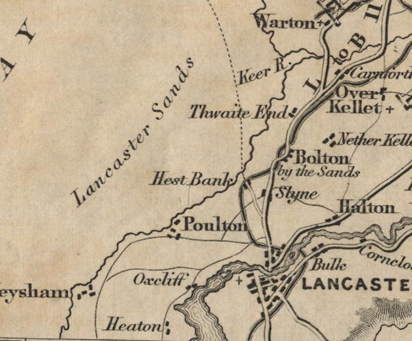 FD02SD46.jpg "Lancaster Sands" item:- JandMN : 100.1 Image © see bottom of page |
|
|
|
||
| evidence:- | old print:- |
|
| source data:- | Print, uncoloured engraving, Grange-over-Sands, Lancashire, published 1900s?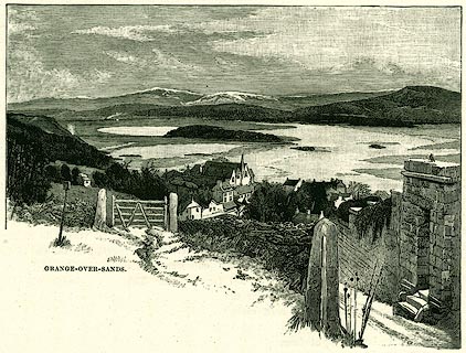 click to enlarge click to enlargePR0325.jpg On page 169 of Our Own Country. Holme Island and Lancaster Sands in the background. printed at bottom:- "GRANGE-OVER-SANDS." item:- Dove Cottage : 2008.107.325 Image © see bottom of page |
|
|
|
||
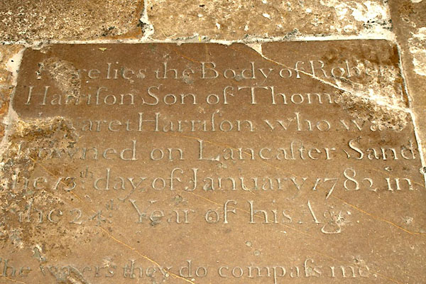 BXJ52.jpg Gravestone, Robert Harrison, drowned 1782. (taken 21.9.2012) |
||
| "Here lies the Body of Robert / Harrison Son of Thomas [ ] / [ ]aret Harrison who wa[
] / drowned on Lancaster Sand / the 13th day of January 1782 in / the 24th. Year of
his Age." |
||
| "The waters they do compass me And no assistance I can see Which makes me to lament and cry Lord send me help least here I die. It is in vain for to withstand, What is decreed by Gods command My dying day I cannot shun Farewell dear Friends my life is run." |
||
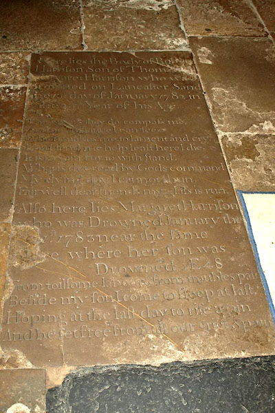 BXJ51.jpg Gravestone, Robert Harrison, drowned 1782. (taken 21.9.2012) |
||
| "Also here lies Margaret Harrison / who was Drowned January the / [ ]1st 1783 near
the same / [ ]ce where her son was / Drowned. AE 48" |
||
| "From toilsome labour & from troubles pain / Beside my son I come to sleep at last.
/ Hoping at the last day to rise again / And be set free from all our grief & pain" |
||
|
|
||
Lakes Guides menu.