 Old Cumbria Gazetteer
 |
 |
|
||
| Leck Beck | ||||
| runs into:- |  Lune, River Lune, River |
|||
|
|
||||
| civil parish:- | Casterton (formerly Westmorland) | |||
| county:- | Cumbria | |||
| locality type:- | river | |||
| locality type:- | boundary | |||
| locality type:- | county boundary | |||
| 1Km square:- | SD6175 (etc) | |||
| 10Km square:- | SD67 | |||
| county:- | Lancashire | |||
| SummaryText:- | mostly in Lancashire; rises in Westmorland | |||
|
|
||||
| evidence:- | old map:- OS County Series (Wmd 48 6) placename:- Leck Beck |
|||
| source data:- | Maps, County Series maps of Great Britain, scales 6 and 25
inches to 1 mile, published by the Ordnance Survey, Southampton,
Hampshire, from about 1863 to 1948. |
|||
|
|
||||
| evidence:- | old map:- Saxton 1579 |
|||
| source data:- | Map, hand coloured engraving, Westmorlandiae et Cumberlandiae Comitatus ie Westmorland
and Cumberland, scale about 5 miles to 1 inch, by Christopher Saxton, London, engraved
by Augustinus Ryther, 1576, published 1579-1645.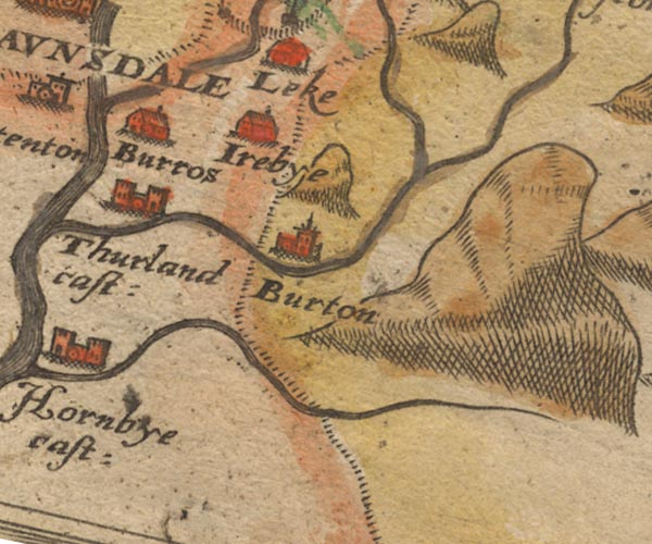 Sax9SD67.jpg item:- private collection : 2 Image © see bottom of page |
|||
|
|
||||
| evidence:- | old map:- Speed 1611 (Wmd) |
|||
| source data:- | Map, hand coloured engraving, The Countie Westmorland and
Kendale the Cheif Towne, scale about 2.5 miles to 1 inch, by
John Speed, 1610, published by George Humble, Popes Head Alley,
London, 1611-12.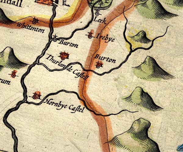 SP14SD67.jpg double line, into the Lune item:- Armitt Library : 2008.14.5 Image © see bottom of page |
|||
|
|
||||
| evidence:- | old map:- Sanson 1679 |
|||
| source data:- | Map, hand coloured engraving, Ancien Royaume de Northumberland
aujourdhuy Provinces de Nort, ie the Ancient Kingdom of
Northumberland or the Northern Provinces, scale about 9.5 miles
to 1 inch, by Nicholas Sanson, Paris, France, 1679. click to enlarge click to enlargeSAN2Cm.jpg tapering wiggly line; river, county boundary item:- Dove Cottage : 2007.38.15 Image © see bottom of page |
|||
|
|
||||
| evidence:- | old map:- Seller 1694 (Wmd) |
|||
| source data:- | Map, hand coloured engraving, Westmorland, scale about 8 miles
to 1 inch, by John Seller, 1694. click to enlarge click to enlargeSEL7.jpg tapering wiggly line; river, south of the county boundary item:- Dove Cottage : 2007.38.87 Image © see bottom of page |
|||
|
|
||||
| evidence:- | old map:- Morden 1695 (Wmd) |
|||
| source data:- | Map, hand coloured engraving, Westmorland, scale about 2.5 miles to 1 inch, by Robert
Morden, published by Abel Swale, the Unicorn, St Paul's Churchyard, Awnsham, and John
Churchill, the Black Swan, Paternoster Row, London, 1695. MD10SD67.jpg item:- JandMN : 24 Image © see bottom of page |
|||
|
|
||||
| evidence:- | old map:- Bowen and Kitchin 1760 |
|||
| source data:- | Map, hand coloured engraving, A New Map of the Counties of
Cumberland and Westmoreland Divided into their Respective Wards,
scale about 4 miles to 1 inch, by Emanuel Bowen and Thomas
Kitchin et al, published by T Bowles, Robert Sayer, and John
Bowles, London, 1760. BO18SD68.jpg wiggly line, into the Lune, county boundary Westmorland Lancashire item:- Armitt Library : 2008.14.10 Image © see bottom of page |
|||
|
|
||||
| evidence:- | descriptive text:- West 1778 (11th edn 1821) |
|||
| source data:- | Guide book, A Guide to the Lakes, by Thomas West, published by
William Pennington, Kendal, Cumbria once Westmorland, and in
London, 1778 to 1821. goto source Tour to the Caves in the West Riding of Yorkshire, late 18th century Page 242:- "..." "... at Overborough, ... A stranger, in going from the hall to the gardens, must be struck with a surprise bordering on terror, on viewing the profound and gloomy glen by the side of his way. The trees which guard this steep bank prevent the eye from seeing the river Leck, which flows through a chasm" goto sourcePage 243:- "amongst rocks at the bottom: imagination is left to conceive the cause of the deep and solemn murmurs beneath." |
|||
|
|
||||
| places:- |
|
|||
|
||||
Lakes Guides menu.