 Old Cumbria Gazetteer
 |
 |
|
| Legburthwaite Mill, St John's Castlerigg etc | ||
| Legburthwaite Mill | ||
| site name:- | Mill Gill | |
| locality:- | Legburthwaite | |
| civil parish:- | St John's Castlerigg and Wythburn (formerly Cumberland) | |
| county:- | Cumbria | |
| locality type:- | buildings | |
| locality type:- | mill (ex) | |
| locality type:- | water mill | |
| locality type:- | corn mill | |
| locality type:- | flood | |
| coordinates:- | NY31911973 | |
| 1Km square:- | NY3119 | |
| 10Km square:- | NY31 | |
|
|
||
| evidence:- | old map:- OS County Series (Cmd 64 16) placename:- Legberthwaite Mill |
|
| source data:- | Maps, County Series maps of Great Britain, scales 6 and 25
inches to 1 mile, published by the Ordnance Survey, Southampton,
Hampshire, from about 1863 to 1948. "Legberthwaite Mill (Corn)" |
|
|
|
||
| evidence:- | old text:- Gents Mag item:- flood, 1749 |
|
| source data:- | Magazine, The Gentleman's Magazine or Monthly Intelligencer or
Historical Chronicle, published by Edward Cave under the
pseudonym Sylvanus Urban, and by other publishers, London,
monthly from 1731 to 1922. goto source goto sourceGentleman's Magazine 1751 p.200 "..." "ON the 22d of August 1749, there was the most terrible thunder, and incessant lightning, ... swept away a mill and a kiln in five minutes, leaving the place where they stood covered with huge rocks and rubbish, 3 or 4 yards deep; so that one of the mill stones cannot be found. ..." |
|
|
|
||
| evidence:- | old map:- Donald 1774 (Cmd) |
|
| source data:- | Map, hand coloured engraving, 3x2 sheets, The County of Cumberland, scale about 1
inch to 1 mile, by Thomas Donald, engraved and published by Joseph Hodskinson, 29
Arundel Street, Strand, London, 1774.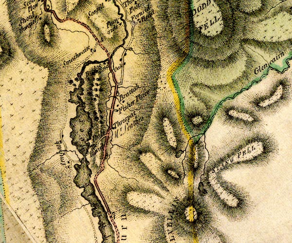 D4NY31NW.jpg circle with rays, mill wheel; a water mill item:- Carlisle Library : Map 2 Image © Carlisle Library |
|
|
|
||
| evidence:- | old text:- Clarke 1787 placename:- Legberthwaite Mill item:- storm, 1749; rain; flood, 1749 |
|
| source data:- | Guide book, A Survey of the Lakes of Cumberland, Westmorland,
and Lancashire, written and published by James Clarke, Penrith,
Cumberland, and in London etc, 1787; published 1787-93. goto source Page 116:- "..." "We now arrive at the bridge which crosses the river that runs from Thyrill-mere, or Leathes water: here we see Legberthwaite-mill, which with many other buildings was driven away by the violence of the water-spout A.D. 1749, ..." |
|
|
|
||
| evidence:- | old map:- Clarke 1787 map (Ambleside to Keswick) placename:- Legberthwaite Mill |
|
| source data:- | Map, A Map of the Roads Lakes etc between Keswick and Ambleside,
scale about 2.5 ins to 1 mile, by James Clarke, engraved by S J
Neele, 352 Strand, published by James Clarke, Penrith,
Cumberland and in London etc, 1787.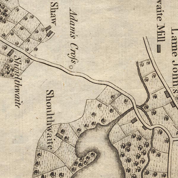 CL9NY31E.jpg "Legberthwaite Mill" item:- private collection : 10.9 Image © see bottom of page |
|
|
|
||
| evidence:- | old print:- Green 1810 (plate 29) placename:- Legberthwaite Mill item:- mill lade |
|
| source data:- | Print, soft ground etching, Mill in Legberthwaite, St John's Castlerigg and Wythburn,
Cumberland, by William Green, Ambleside, Westmorland, 1809.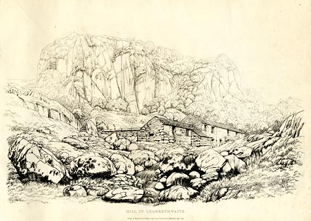 click to enlarge click to enlargeGN1229.jpg The crag behind is Castle Rock. Plate 29 in Sixty Studies from Nature, 1810. printed at top right:- "29" printed at bottom:- "MILL IN LEGBERTHWAITE. / Drawn &Engraved by William Green, and Published at Ambleside, Augst. 1, 1809." watermark:- "J WHATMAN / 1813" item:- Armitt Library : A6641.29 Image © see bottom of page |
|
|
|
||
| evidence:- | old print:- Wilkinson 1810 (plate 19) placename:- Legbethwaite Mill item:- rain |
|
| source data:- | Print, uncoloured soft ground etching, Legbethwaite Mill, St John's Vale, taken after
much rain, Cumberland, by Joseph Wilkinson, engraved by William Frederick Wells, published
by R Ackermann, Repository of Arts, 101 Strand, London, 1810.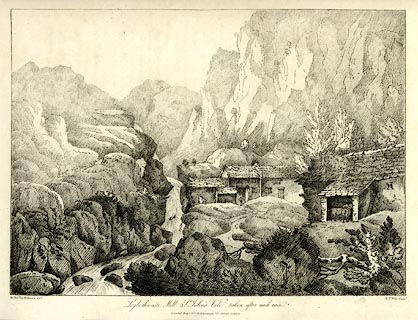 click to enlarge click to enlargeWKN119.jpg Plate 19 in Select Views in Cumberland, Westmoreland, and Lancashire. printed at bottom left, right, centre:- "The Revd. Jos: Wilkinson delt. / W. F. Wells sculpt. / Legbethwaite Mill, St John's Vale, taken after much rain. / Published May 1. 1810. by R. Ackermann. 101. Strand. London." item:- Fell and Rock Climbing Club : MN4.19 Image © see bottom of page |
|
|
|
||
| evidence:- | descriptive text:- Ford 1839 (3rd edn 1843) placename:- Legberthwaite Mill |
|
| source data:- | Guide book, A Description of Scenery in the Lake District, by
Rev William Ford, published by Charles Thurnam, Carlisle, by W
Edwards, 12 Ave Maria Lane, Charles Tilt, Fleet Street, William
Smith, 113 Fleet Street, London, by Currie and Bowman,
Newcastle, by Bancks and Co, Manchester, by Oliver and Boyd,
Edinburgh, and by Sinclair, Dumfries, 1839. goto source Page 63:- "... Legberthwaite Mill at its [Castle Rock's] foot was destroyed some seventy years ago by a water-spout, all the destructive traces of which the healing hand of time has effaced. ..." |
|
|
|
||
Lakes Guides menu.