 Old Cumbria Gazetteer
 |
 |
|
| Levens Force, Levens | ||
| Levens Force | ||
| site name:- | Kent, River | |
| civil parish:- | Levens (formerly Westmorland) | |
| civil parish:- | Sedgwick (formerly Westmorland) | |
| county:- | Cumbria | |
| locality type:- | waterfall | |
| coordinates:- | SD50798655 | |
| 1Km square:- | SD5086 | |
| 10Km square:- | SD58 | |
|
|
||
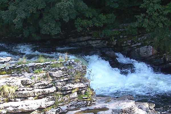 BJU80.jpg a moment earlier a salmon leapt! (taken 12.9.2005) |
||
|
|
||
| evidence:- | descriptive text:- Keer 1605 (edn 1620) item:- catadupa |
|
| source data:- | Map, Westmorlandia et Comberlandia, ie Westmorland and
Cumberland now Cumbria, scale about 16 miles to 1 inch, probably
by Pieter van den Keere, or Peter Keer, about 1605, published
about 1605 to 1676. goto source goto sourcefourth page "... There are also neere Kendale in the River Can, two Catadupa or Waterfals, where the waters descend with such a forcible downefall, that it compels a mightie noyse to be heard, which the neighbour Inhabitants make such use of, as they stand them in as good stead as Prognostications: for when that which standeth North from them soundeth more cleare, and with a louder eccho in their eares, they certainly looke for faire weather to follow: But when that on the South do the like, they expect foggy mists and showers of raine." |
|
|
|
||
| evidence:- | poem:- Drayton 1612/1622 text placename:- Catadupa item:- weather signs; rain |
|
| source data:- | Poem, Poly Olbion, by Michael Drayton, published by published by
John Marriott, John Grismand and Thomas Dewe, and others?
London, part 1 1612, part 2 1622. goto source page 161:- "... Where Can ... Tow'rds the Verginian Sea, by her two mighty Falls, (Which the brave Roman tongue, her Catadupa calls) This eager River seemes outragiousy to rore, And counterfetting Nyle, to deafe the neighboring shore," goto sourcepage 162:- "To which she by the sound apparantly doth show, The season foule of faire, as then the wind doth blow: For when they to the North, the noyse doe easiest heare, They constantly affirme the weather will be cleere; And when they to the South, againe they boldly say, It will be clouds or raine the next approaching day." |
|
|
|
||
| evidence:- | old map:- Jefferys 1770 (Wmd) placename:- Forse |
|
| source data:- | Map, 4 sheets, The County of Westmoreland, scale 1 inch to 1
mile, surveyed 1768, and engraved and published by Thomas
Jefferys, London, 1770. J5SD58NW.jpg "Forse" waterfall item:- National Library of Scotland : EME.s.47 Image © National Library of Scotland |
|
|
|
||
| evidence:- | descriptive text:- West 1778 (11th edn 1821) |
|
| source data:- | Guide book, A Guide to the Lakes, by Thomas West, published by
William Pennington, Kendal, Cumbria once Westmorland, and in
London, 1778 to 1821. goto source Page 185:- "... If you ride down the west side of the river from the bridge, as far as the forge, to see the water-fall of the whole river, let it be remembered, that the stream is much impaired in beauty since the forge was erected. And if, from the end of the uppermost house, you look up between the trees in the midst of the channel, you will see the whole body of the river issuing from a sable cavern, and tumbling over a rock, of height just sufficient to convert it into a froth as white as snow, and behind it the arch of the bridge is partly caught in a disposition that forms a very uncommon assemblage of picturesque beauties. This is seen in the highest perfection when then stream is full." goto sourceAddendum; Mr Gray's Journal, 1769 Page 215:- "..." "After dinner I went along the Millthorp turnpike, four miles to see the falls, or force of the river Kent; came to Sizergh ... I soon came to the river; it works its way in a narrow and deep rocky channel, overhung with trees. The calmness and brightness of the evening, the roar of the waters, and the thumping of huge hammers at an iron forge not far distant, made it a singular walk; but as to the falls (for there are two) they are not four feet high. ..." |
|
|
|
||
| evidence:- | old map:- West 1784 map |
|
| source data:- | Map, hand coloured engraving, A Map of the Lakes in Cumberland,
Westmorland and Lancashire, scale about 3.5 miles to 1 inch,
engraved by Paas, 53 Holborn, London, about 1784.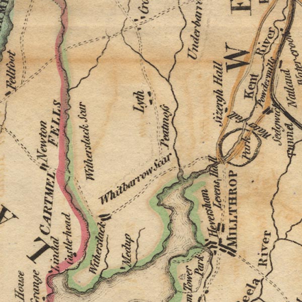 Ws02SD48.jpg "Waterfall" item:- Armitt Library : A1221.1 Image © see bottom of page |
|
|
|
||
| evidence:- | old text:- Camden 1789 item:- weather signs |
|
| source data:- | Book, Britannia, or A Chorographical Description of the Flourishing Kingdoms of England,
Scotland, and Ireland, by William Camden, 1586, translated from the 1607 Latin edition
by Richard Gough, published London, 1789. goto source Page 147:- "... Lower down [below Kendal] in the river Can are two falls, down which the water rushes with great noise, one at the little town of Levens, the other more to the south near Betham, which are certain prognostics of weather to the neighbourhood. For, when the northernmost makes a loud noise they expect fair weather, and when the southernmost does the same rain and fogs. ..." |
|
|
|
||
| evidence:- | old text:- Camden 1789 (Gough Additions) placename:- Levens Fall |
|
| source data:- | Book, Britannia, or A Chorographical Description of the Flourishing Kingdoms of England,
Scotland, and Ireland, by William Camden, 1586, translated from the 1607 Latin edition
by Richard Gough, published London, 1789. goto source Page 153:- "..." "The phaenomenon of Levens and Betham fall is thus to be explained. When that which is to the north sounds more loud and clear, the inhabitants look for sour weather; when that to the south, for rain; the south-west winds blowing from the sea bring the vapors with them, and from the north-east have the contrary effect." |
|
|
|
||
Lakes Guides menu.