Old Cumbria Gazetteer
 |
 |
|
||
| Little Musgrave, Musgrave | ||||
| Little Musgrave | ||||
| civil parish:- | Musgrave (formerly Westmorland) | |||
| county:- | Cumbria | |||
| locality type:- | locality | |||
| locality type:- | buildings | |||
| coordinates:- | NY75961314 (etc) | |||
| 1Km square:- | NY7513 | |||
| 10Km square:- | NY71 | |||
|
|
||||
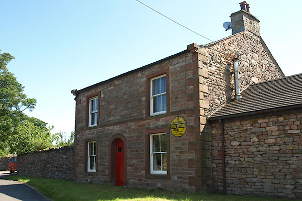
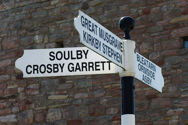
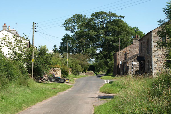 BVA93.jpg (taken 24.7.2011) 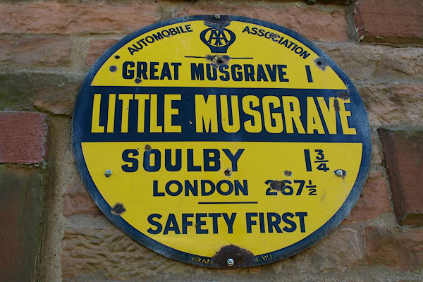 BVA95.jpg AA village sign, on Eden View Farm. (taken 24.7.2011) |
||||
|
|
||||
| evidence:- | old map:- Saxton 1579 placename:- Musgrave Parva |
|||
| source data:- | Map, hand coloured engraving, Westmorlandiae et Cumberlandiae Comitatus ie Westmorland
and Cumberland, scale about 5 miles to 1 inch, by Christopher Saxton, London, engraved
by Augustinus Ryther, 1576, published 1579-1645.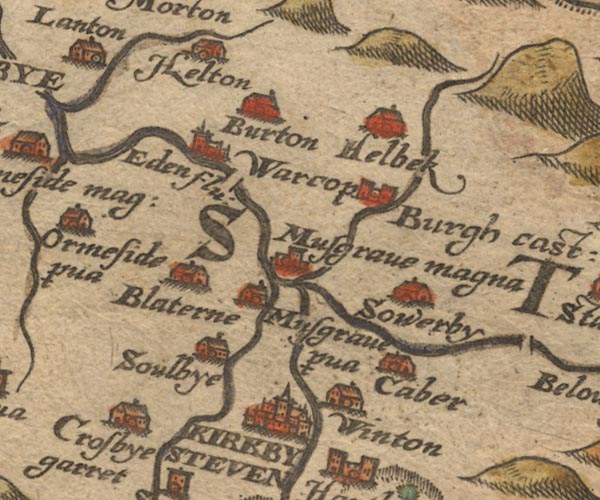 Sax9NY71.jpg Building, symbol for a hamlet, which may or may not have a nucleus. "Musgrave p~va" item:- private collection : 2 Image © see bottom of page |
|||
|
|
||||
| evidence:- | old map:- Speed 1611 (Wmd) placename:- Little Musgrave |
|||
| source data:- | Map, hand coloured engraving, The Countie Westmorland and
Kendale the Cheif Towne, scale about 2.5 miles to 1 inch, by
John Speed, 1610, published by George Humble, Popes Head Alley,
London, 1611-12.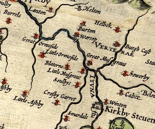 SP14NY71.jpg "Little Musgrave" circle, tower item:- Armitt Library : 2008.14.5 Image © see bottom of page |
|||
|
|
||||
| evidence:- | old map:- Jansson 1646 placename:- Little Musgrave |
|||
| source data:- | Map, hand coloured engraving, Cumbria and Westmoria, ie
Cumberland and Westmorland, scale about 3.5 miles to 1 inch, by
John Jansson, Amsterdam, Netherlands, 1646.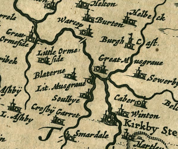 JAN3NY71.jpg "Lit. Musgrave" Buildings and tower. item:- JandMN : 88 Image © see bottom of page |
|||
|
|
||||
| evidence:- | hearth tax returns:- Hearth Tax 1675 placename:- Little Musgrave |
|||
| source data:- | Records, hearth tax survey returns, Westmorland, 1674/75. "Little Musgrave" |
|||
|
|
||||
| evidence:- | hearth tax returns:- Hearth Tax 1670 placename:- Litle Musgrave |
|||
| source data:- | Records, hearth tax returns, exchequer duplicates, Westmorland,
1670. "Litle Musgrave" |
|||
|
|
||||
| evidence:- | old map:- Morden 1695 (Wmd) placename:- Little Musgrave |
|||
| source data:- | Map, hand coloured engraving, Westmorland, scale about 2.5 miles to 1 inch, by Robert
Morden, published by Abel Swale, the Unicorn, St Paul's Churchyard, Awnsham, and John
Churchill, the Black Swan, Paternoster Row, London, 1695.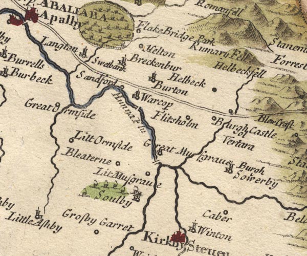 MD10NY71.jpg "Lit Musgrave" Circle. item:- JandMN : 24 Image © see bottom of page |
|||
|
|
||||
| evidence:- | possibly old map:- Simpson 1746 map (Wmd) placename:- Musgrave |
|||
| source data:- | Map, uncoloured engraving, Westmorland, scale about 8 miles to 1
inch, printed by R Walker, Fleet Lane, London, 1746.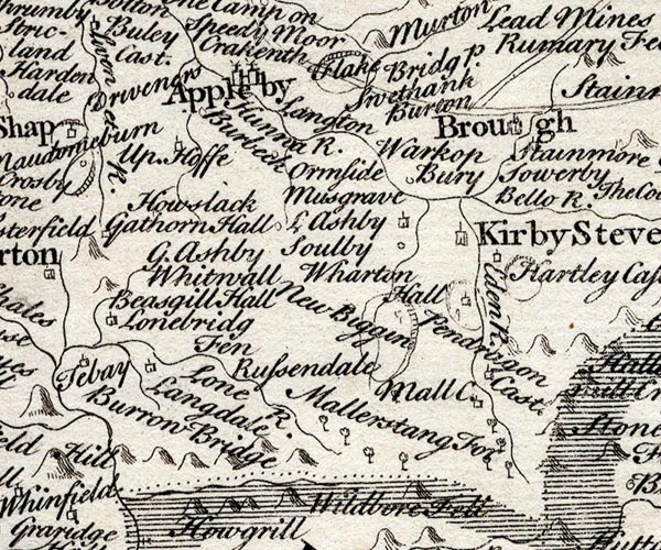 SMP2NYQ.jpg "Musgrave" item:- Dove Cottage : 2007.38.59 Image © see bottom of page |
|||
|
|
||||
| evidence:- | old map:- Bowen and Kitchin 1760 placename:- Little Musgrave |
|||
| source data:- | Map, hand coloured engraving, A New Map of the Counties of
Cumberland and Westmoreland Divided into their Respective Wards,
scale about 4 miles to 1 inch, by Emanuel Bowen and Thomas
Kitchin et al, published by T Bowles, Robert Sayer, and John
Bowles, London, 1760.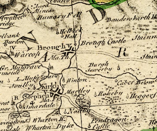 BO18NY71.jpg "L. Musgrave" circle, tower item:- Armitt Library : 2008.14.10 Image © see bottom of page |
|||
|
|
||||
| evidence:- | old map:- Jefferys 1770 (Wmd) placename:- Little Musgrave placename:- Musgrave, Little |
|||
| source data:- | Map, 4 sheets, The County of Westmoreland, scale 1 inch to 1
mile, surveyed 1768, and engraved and published by Thomas
Jefferys, London, 1770. J5NY71SE.jpg "Little Musgrave" blocks, labelled in upright lowercase text; settlement; town? item:- National Library of Scotland : EME.s.47 Image © National Library of Scotland |
|||
|
|
||||
| evidence:- | old text:- Camden 1789 placename:- Musgrave |
|||
| source data:- | Book, Britannia, or A Chorographical Description of the Flourishing Kingdoms of England,
Scotland, and Ireland, by William Camden, 1586, translated from the 1607 Latin edition
by Richard Gough, published London, 1789. goto source goto sourcePage 147:- "... It [River Eden] afterwards runs by ... two villages of the name Musgrave which give name to the warlike family of Musgrave, of whom t. Edward III. Thomas Musgrave had summons to parliament among the barons; Heartly castle in this neighbourhood was their residence." |
|||
|
|
||||
| evidence:- | old text:- Camden 1789 (Gough Additions) placename:- Little Musgrave item:- march warden |
|||
| source data:- | Book, Britannia, or A Chorographical Description of the Flourishing Kingdoms of England,
Scotland, and Ireland, by William Camden, 1586, translated from the 1607 Latin edition
by Richard Gough, published London, 1789. Page 156:- "..." "The villages of Great and Little Musgrave may seem rather to derive their name from the family, their name being taken from their office Musgrave or Mosgreve equivalent to Warden of the Marches, which office they held, and not improbably the same with Markgrave. They are as old here as Peter Musgrave in the reign of Stephen. Richard Musgrave his lineal descendant was created knight of the bath, and a baronet by James I. His son Philip distinguished himself on the king's side in the civil war, and defended the Isle of Man for the countess of Derby, and, at the Restoration, had a warrant for creating him baron Musgrave of Hartley castle, but never took out the patent. The present baronet Philip is the 5th in lineal descent from him. The family burial-place is at Eden-hall, repaired and beautified by sir Richard Musgrave the 1st baronet, who died and was buried at Naples 13 James I. The late sir Christopher Musgrave in a great measure demolished the noble pile, and employed the materials on his seat at Eden-hall." |
|||
|
|
||||
| evidence:- | old map:- Cary 1789 (edn 1805) placename:- Little Musgrave placename:- Musgrave, Little |
|||
| source data:- | Map, uncoloured engraving, Westmoreland, scale about 2.5 miles
to 1 inch, by John Cary, London, 1789; edition 1805. CY24NY71.jpg "Little Musgrave" block/s, labelled in italic lowercase; house, or hamlet item:- JandMN : 129 Image © see bottom of page |
|||
|
|
||||
| evidence:- | old map:- Ford 1839 map placename:- Little Musgrave |
|||
| source data:- | Map, uncoloured engraving, Map of the Lake District of
Cumberland, Westmoreland and Lancashire, scale about 3.5 miles
to 1 inch, published by Charles Thurnam, Carlisle, and by R
Groombridge, 5 Paternoster Row, London, 3rd edn 1843. FD02NY71.jpg "Lit. Musgrave" item:- JandMN : 100.1 Image © see bottom of page |
|||
|
|
||||
| places:- |
|
|||
|
||||
|
||||
|
||||
|
||||
|
||||
Lakes Guides menu.