 Old Cumbria Gazetteer
 |
 |
|
| Loughrigg Tarn, Loughrigg | ||
| Loughrigg Tarn | ||
| locality:- | Loughrigg | |
| civil parish:- | Lakes (formerly Westmorland) | |
| county:- | Cumbria | |
| locality type:- | tarn | |
| coordinates:- | NY34460434 (etc) | |
| 1Km square:- | NY3404 | |
| 10Km square:- | NY30 | |
|
|
||
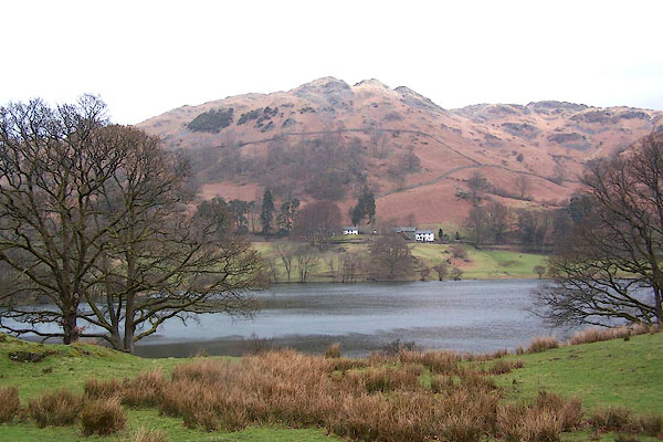 BLV35.jpg (taken 13.4.2006) 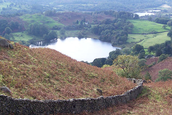 BPS48.jpg (taken 6.10.2008) |
||
|
|
||
| evidence:- | old map:- OS County Series (Wmd 26 9) placename:- Loughrigg Tarn |
|
| source data:- | Maps, County Series maps of Great Britain, scales 6 and 25
inches to 1 mile, published by the Ordnance Survey, Southampton,
Hampshire, from about 1863 to 1948. |
|
|
|
||
| evidence:- | old map:- Jefferys 1770 (Wmd) |
|
| source data:- | Map, 4 sheets, The County of Westmoreland, scale 1 inch to 1
mile, surveyed 1768, and engraved and published by Thomas
Jefferys, London, 1770.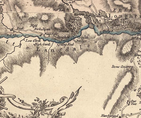 J5NY30SW.jpg outline with form lines; lake or tarn item:- National Library of Scotland : EME.s.47 Image © National Library of Scotland |
|
|
|
||
| evidence:- | descriptive text:- West 1778 (11th edn 1821) |
|
| source data:- | Guide book, A Guide to the Lakes, by Thomas West, published by
William Pennington, Kendal, Cumbria once Westmorland, and in
London, 1778 to 1821. goto source goto sourceRev Plumtre's Night Piece on Windermere, 1797 Page 231:- "[1] The river Brathay is formed chiefly from two steams,- the one rising in Little Langdale, the other in Great Langdale, ... Another of its feeders is the stream from Loughrigg Tarn, a very small but beautiful lake, in the bosom of the mountains, a little to the right of the road as you cross over from Elter-water, or Skelwith-bridge, to Grasmere. / ..." |
|
|
|
||
| evidence:- | old map:- Cary 1789 (edn 1805) |
|
| source data:- | Map, uncoloured engraving, Westmoreland, scale about 2.5 miles
to 1 inch, by John Cary, London, 1789; edition 1805.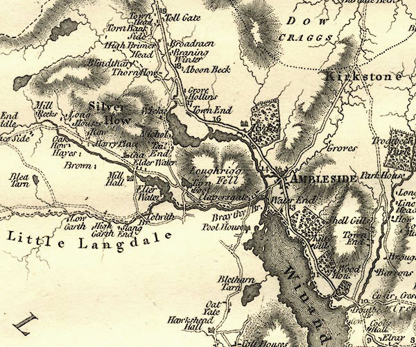 CY24NY30.jpg outline with shore form lines; lake or tarn item:- JandMN : 129 Image © see bottom of page |
|
|
|
||
| evidence:- | old drawing:- Green 1790s-1820s (1810) placename:- Loughrigg Tarn |
|
| source data:- | Drawing, pencil, Loughrigg Tarn and Windermere from High Close, Westmorland, by William
Green, Ambleside, Westmorland, 28 September 1810.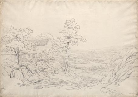 click to enlarge click to enlargePR1759.jpg ms, pencil at lower left, right:- "Sep 28 1810 / Loughrigg Tarn and Windermere from High Close" item:- Dove Cottage : B46 Image © see bottom of page |
|
|
|
||
| evidence:- | old text:- Wordsworth 1810 placename:- Loughrigg Tarn |
|
| source data:- | Guide book, A Description of the Scenery of the Lakes, later A
Guide through the District of The Lakes, by William Wordsworth,
1810-35. goto source page 24 "... when the shores of the Tarn are determined, it differs only from the Lake in being smaller, and in belonging mostly to a smaller valley, or circular recess. Of this class of miniature lakes, Loughrigg Tarn, near Grasmere, is the most beautiful example. It has a margin of green firm meadow, of rocks, and rocky woods, a few reeds here, a little company of water-lilies there, with beds of gravel or stone beyond; a tiny stream issuing neither briskly nor sluggishly out of it; but its feeding rills, from the shortness of their course, so small as to be scarcely visible. Five" goto sourcepage 25 "or six cottages are reflected in its peaceful bosom; rocky and barren steeps rise up above the hanging enclosures; and the solemn pikes of Langdale overlook, from a distance, the low cultivated ridge of land that forms the northern boundary of this small, quiet, and fertile domain. ..." |
|
|
|
||
| evidence:- | old print:- Green 1814 (plate 17) placename:- Loughrigg Tarn item:- fishing |
|
| source data:- | Print, uncoloured soft ground etching, Loughrigg Tarn, Loughrigg, Westmorland, by
William Green, Ambleside, Westmorland, 1814.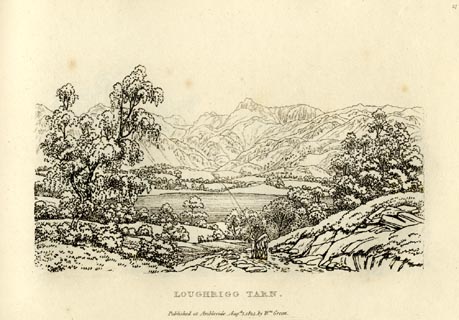 click to enlarge click to enlargeGN0917.jpg Plate 17 in Sixty Small Prints. printed at top right:- "17" printed at bottom:- "LOUGHRIGG TARN. / Published at Ambleside Augst. 1, 1814, by Wm. Green." item:- Armitt Library : A6656.17 Image © see bottom of page |
|
|
|
||
| evidence:- | old print:- Green 1814 (plate 17) placename:- Loughrigg Tarn item:- fishing |
|
| source data:- | Print, tinted soft ground etching, Loughrigg Tarn, Loughrigg, Westmorland, by William
Green, Ambleside, Westmorland, 1814.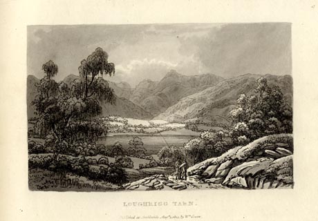 click to enlarge click to enlargeGN1017.jpg Plate 17 in Sixty Small Prints. printed at top right:- "17" printed at bottom:- "LOUGHRIGG TARN. / Published at Ambleside Augst. 1, 1814, by Wm. Green." item:- Armitt Library : A6653.17 Image © see bottom of page |
|
|
|
||
| evidence:- | old print:- Green 1815 placename:- Loughrigg Tarn |
|
| source data:- | Print, coloured aquatint, Loughrigg Tarn, Loughrigg, Westmorland, by William Green,
Ambleside, Westmorland, 1815.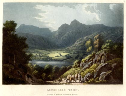 click to enlarge click to enlargeGN0516.jpg Plate 17 in Lake Scenery. printed at upper right:- "17" printed at bottom:- "LOUGHRIGG TARN. / Published at Ambleside, June 1, 1815, by Wm. Green." item:- Armitt Library : A6646.16 Image © see bottom of page |
|
|
|
||
| evidence:- | old map:- Otley 1818 |
|
| source data:- | Map, uncoloured engraving, The District of the Lakes,
Cumberland, Westmorland, and Lancashire, scale about 4 miles to
1 inch, by Jonathan Otley, 1818, engraved by J and G Menzies,
Edinburgh, Scotland, published by Jonathan Otley, Keswick,
Cumberland, et al, 1833.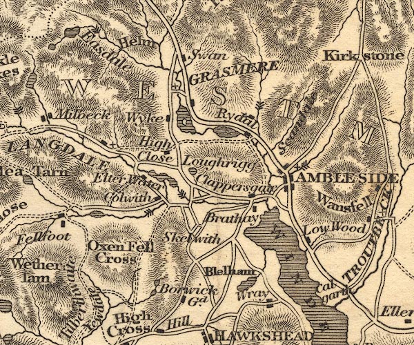 OT02NY30.jpg item:- JandMN : 48.1 Image © see bottom of page |
|
|
|
||
| evidence:- | old print:- Otley 1823 (8th edn 1849) placename:- Loughrigg Tarn |
|
| source data:- | Engraving, Loughrigg Tarn with Langdale Pikes, drawn by T Binns, engraved by O Jewitt,
on p.1 of A Descriptive Guide of the English Lakes, by Jonathan Otley, 8th edition,
1849.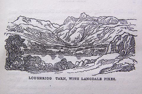 click to enlarge click to enlargeO80E01.jpg item:- Armitt Library : A1180.2 Image © see bottom of page |
|
|
|
||
| evidence:- | descriptive text:- Otley 1823 (5th edn 1834) |
|
| source data:- | Guide book, A Concise Description of the English Lakes, the
mountains in their vicinity, and the roads by which they may be
visited, with remarks on the mineralogy and geology of the
district, by Jonathan Otley, published by the author, Keswick,
Cumberland now Cumbria, by J Richardson, London, and by Arthur
Foster, Kirkby Lonsdale, Cumbria, 1823; published 1823-49,
latterly as the Descriptive Guide to the English Lakes. goto source Page 33:- "... Loughrigg Tarn is a circular piece of water of about twenty acres, environed by green meadows, intermixed with rocky woods and cultivated grounds. Its glassy surface displays beautiful reflections of the farm-houses, fields, and trees, surmounted by rocky steeps; and when taken in combination with Langdale Pikes in the distance, it makes an excellent picture. ..." "..." goto sourcePage 105:- "AMBLESIDE TO LOUGHRIGG FELL, AND LOUGHRIGG TARN." "... on reaching the top of Ivy Crag, a" goto sourcePage 106:- "large rock overlooking Loughrigg Tarn, he will have an instantaneous burst upon a most extraordinary assemblage of landscape beauties. Returning from the top of the rock, and proceeding by the path, he will soon perceive Loughrigg Tarn in the best position for a picture; having Langdale Pikes in the distance. ..." |
|
|
|
||
| evidence:- | descriptive text:- Ford 1839 (3rd edn 1843) placename:- Loughrigg Tarn |
|
| source data:- | Guide book, A Description of Scenery in the Lake District, by
Rev William Ford, published by Charles Thurnam, Carlisle, by W
Edwards, 12 Ave Maria Lane, Charles Tilt, Fleet Street, William
Smith, 113 Fleet Street, London, by Currie and Bowman,
Newcastle, by Bancks and Co, Manchester, by Oliver and Boyd,
Edinburgh, and by Sinclair, Dumfries, 1839. goto source Page 35:- "..." "LOUGHRIGG FELL AND TARN." "... Loughrigg Tarn lies under the west end of the Fell [Loughrigg Fell], having a margin of firm green meadows, reeds, and lilies, adorning its tiny bays, which are bordered here and there with gravel, whilst a small stream issues out of it. A few cottages are reflected in its bosom, above which rise rocky and barren steeps, intermingled with wood; and the solemn" goto sourcePage 36:- "Pikes of Langdale overlook the low, cultivated ridge of land, that forms the northern boundary of this small, quiet, and fertile spot." |
|
|
|
||
| evidence:- | old drawing:- Aspland 1840s-60s placename:- Loughrigg Tarn |
|
| source data:- | Drawing, pencil, Loughrigg Tarn, Westmorland, by Theophilus Lindsey Aspland, 1849.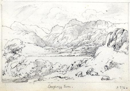 click to enlarge click to enlargeAS0144.jpg "Loughrigg Tarn. / p 274." item:- Armitt Library : 1958.487.44 Image © see bottom of page |
|
|
|
||
| evidence:- | old map:- Garnett 1850s-60s H |
|
| source data:- | Map of the English Lakes, in Cumberland, Westmorland and
Lancashire, scale about 3.5 miles to 1 inch, published by John
Garnett, Windermere, Westmorland, 1850s-60s.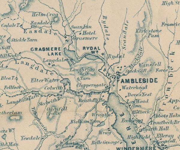 GAR2NY30.jpg "Tarn" lak item:- JandMN : 82.1 Image © see bottom of page |
|
|
|
||
| evidence:- | old text:- Martineau 1855 |
|
| source data:- | Guide book, A Complete Guide to the English Lakes, by Harriet
Martineau, published by John Garnett, Windermere, Westmorland,
and by Whittaker and Co, London, 1855; published 1855-76. goto source Page 47:- "... After a while, he comes to a sheet of water, so still, if the day be calm, that he might possibly miss it, unless the precision of the reflections should strike his eye. It is more likely, however, to be rippled by some breeze, and to show how deeply blue, or darkly grey, these mountain tarns may be. This is Loughrigg tarn, well known to all readers of Wordsworth. ..." |
|
|
|
||
| evidence:- | old print:- Payn 1867 placename:- Loughrigg Tarn |
|
| source data:- | Print, uncoloured engraving, Loughrigg Tarn, Loughrigg, Westmorland, by T L Aspland,
engraved by Orrin Smith? published by J Garnett, Windermere, Westmorland, 1867.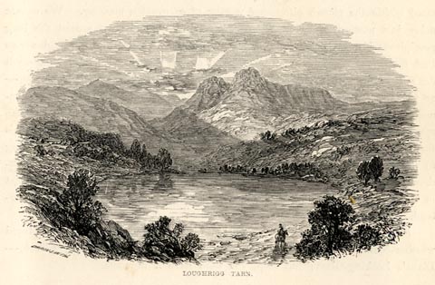 click to enlarge click to enlargePN0320.jpg On p.42 of The Lakes in Sunshine, text by James Payn. printed at lower left:- "[ORRIN] SMITH" printed at bottom:- "LOUGHRIGG TARN." item:- Fell and Rock Climbing Club : 184.20 Image © see bottom of page |
|
|
|
||
| evidence:- | old photograph:- Bell 1880s-1940s |
|
| source data:- | Photograph, black and white, Loughrigg Tarn, Loughrigg, Westmorland, by Herbert Bell,
photographer, Ambleside, Westmorland, 1890s? click to enlarge click to enlargeHB0953.jpg item:- Armitt Library : 1958.4260 Image © see bottom of page |
|
|
|
||
| evidence:- | old photograph:- Bell 1880s-1940s |
|
| source data:- | Photograph, black and white, Loughrigg Tarn, Loughrigg, Westmorland, by Herbert Bell,
photographer, Ambleside, Westmorland, 1890s. click to enlarge click to enlargeHB0651.jpg internegative at lower right:- "H. Be[ ]" stamped on reverse:- "HERBERT BELL / Photographer / AMBLESIDE" item:- Armitt Library : ALPS314 Image © see bottom of page |
|
|
|
||
| evidence:- | old photograph:- Bell 1880s-1940s |
|
| source data:- | Photograph, sepia, Loughrigg Tarn etc, Loughrigg, Westmorland, by Herbert Bell, Ambleside,
Westmorland, 1890s. click to enlarge click to enlargeHB0418.jpg internegative at lower right:- "H. Bell." item:- Armitt Library : ALPS72 Image © see bottom of page |
|
|
|
||
| evidence:- | old print:- Goodwin 1887 (edn 1890) placename:- Loughrigg Tarn |
|
| source data:- | Print, etching? Loughrigg Tarn, Westmorland, by Harry Goodwin, published by Swan Sonnenschein
and Co, Paternoster Square, London, 1890.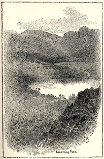 click to enlarge click to enlargePR1593.jpg Tipped in opposite p.112 of Through the Wordsworth Country, by William Knight. printed at lower right of centre:- "Loughrigg Tarn" item:- JandMN : 382.23 Image © see bottom of page |
|
|
|
||
| evidence:- | old print:- Garnett 1850s-60s F |
|
| source data:- | Print, uncoloured engraving, Loughrigg Tarn, Westmorland, engraved by William Banks
and Son, Edinburgh, published by John Garnett, Windermere, Westmorland, 1850s-60s?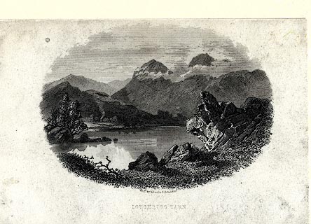 click to enlarge click to enlargeGAR720.jpg Found with Views of the English Lakes. printed at bottom:- "Engd. by W. Banks &Son Edinr. / LOUGHRIGG TARN." item:- JandMN : 165.20 Image © see bottom of page |
|
|
|
||
| evidence:- | old print:- Green 1819 placename:- Loughrigg Tarn |
|
| source data:- | Print, aquatint, Loughrigg Tarn, Westmorland, by William Green, 1819, published by
R Lough and Co, Chronicle Office, Finkle Street, Kendal, and others, 1820.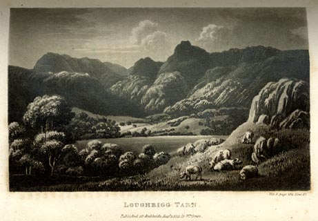 click to enlarge click to enlargeGN0106.jpg Tipped in opposite vol.1 p.274 of The Tourist's New Guide, by William Green. printed at bottom right, centre:- "Vol.I, page 274, line 17. / LOUGHRIGG TARN. / Published at Ambleside, Augt. 1. 1819., by Wm. Green." item:- Armitt Library : A1141.7 Image © see bottom of page |
|
|
|
||
Lakes Guides menu.