 Old Cumbria Gazetteer
 |
 |
|
| Maiden Way | ||
| civil parish:- | Kirkby Thore (formerly Westmorland) | |
| civil parish:- | Newbiggin (formerly Westmorland) | |
| civil parish:- | Milburn (formerly Westmorland) | |
| civil parish:- | Culgaith (formerly Cumberland) | |
| civil parish:- | Ousby (formerly Cumberland) | |
| civil parish:- | Glassonby (formerly Cumberland) | |
| civil parish:- | Alston Moor (formerly Cumberland) | |
| county:- | Cumbria | |
| locality type:- | roman road | |
| locality type:- | road | |
| 10Km square:- | NY62 | |
| 10Km square:- | NY63 | |
| 10Km square:- | NY64 | |
| county:- | Northumberland | |
| locality type:- | roman road | |
| 10Km square:- | NY64 | |
| 10Km square:- | NY65 | |
| 10Km square:- | NY66 | |
|
|
||
| evidence:- | old map:- OS County Series (Cmd 4 6) placename:- Maiden Way |
|
| source data:- | Maps, County Series maps of Great Britain, scales 6 and 25
inches to 1 mile, published by the Ordnance Survey, Southampton,
Hampshire, from about 1863 to 1948. OS County Series (Cmd 8 15) "Maiden Way / ROMAN ROAD (Site of)" |
|
| source data:- | Maps, County Series maps of Great Britain, scales 6 and 25
inches to 1 mile, published by the Ordnance Survey, Southampton,
Hampshire, from about 1863 to 1948. "MAIDEN WAY (ROMAN ROAD)" |
|
| source data:- | Maps, County Series maps of Great Britain, scales 6 and 25
inches to 1 mile, published by the Ordnance Survey, Southampton,
Hampshire, from about 1863 to 1948. "MAIDEN WAY (ROMAN ROAD)" |
|
| source data:- | Maps, County Series maps of Great Britain, scales 6 and 25
inches to 1 mile, published by the Ordnance Survey, Southampton,
Hampshire, from about 1863 to 1948. OS County Series (Cmd 51 6) OS County Series (Cmd 51 14) "Maiden Way (ROMAN ROAD)" |
|
|
|
||
| evidence:- | old map:- Morden 1695 (Wmd) placename:- Maden Way |
|
| source data:- | Map, hand coloured engraving, Westmorland, scale about 2.5 miles to 1 inch, by Robert
Morden, published by Abel Swale, the Unicorn, St Paul's Churchyard, Awnsham, and John
Churchill, the Black Swan, Paternoster Row, London, 1695.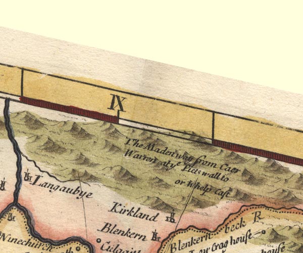 MD10NY63.jpg "The Maden way from Caer Warren at ye Picts wall to or Whelp Cast" Double line. item:- JandMN : 24 Image © see bottom of page |
|
|
|
||
| evidence:- | descriptive text:- Simpson 1746 placename:- Maiden Way |
|
| source data:- | Atlas, three volumes of maps and descriptive text published as
'The Agreeable Historian, or the Compleat English Traveller
...', by Samuel Simpson, 1746. goto source goto sourcePage 1025:- "..." "At Kirkby-Thore begins the old Causey called the Maiden Way, which runs twenty Miles from hence to Caer Vorran near the Picts Wall." |
|
|
|
||
| evidence:- | old map:- Simpson 1746 map (Wmd) |
|
| source data:- | Map, uncoloured engraving, Westmorland, scale about 8 miles to 1
inch, printed by R Walker, Fleet Lane, London, 1746. SMP2NYS.jpg "Maiden Way"  SMP2NYR.jpg Double line. item:- Dove Cottage : 2007.38.59 Image © see bottom of page |
|
|
|
||
| evidence:- | old text:- Gents Mag |
|
| source data:- | Magazine, The Gentleman's Magazine or Monthly Intelligencer or
Historical Chronicle, published by Edward Cave under the
pseudonym Sylvanus Urban, and by other publishers, London,
monthly from 1731 to 1922. goto source Gentleman's Magazine 1755 p.272 "Mr URBAN," "THE first conception, in investigating the original of the names Maiden-Castle, Maiden-Way, and Maiden-Hold, in the county of Westmoreland, in answer to your correspondent's quere, p.198, is this, that the first and last places being apparently places of strength, as may be judged by their names, which import a fortification of some kind, might be so called from their impregnability, as never having been taken by an enemy; just as we read in Hall's Chronicles, that over the one of the gates of the city of Tournay, Temp. Henry VIII. was written Jamais ton ne a perdue ton pucellage, Thou hast never lost thy maidenhead. And as the motto of Waterford in Ireland formerly imported, Intacta manet Waterfordia, where intacta means virginea, as Hor. Od. i. 7. and Juv. vi. 163, &annot Ovid Art. Am. i. 677. But then this interpretation is not so applicable to a road, or the Maiden-way, the other place mentioned in the query, wherefore admitting, upon the suggestion of the proposer, that all three places were known to the Romans, I rather incline to think, that the first part of these compounds may be of a British original; that the ancient Britons in their time had been settled in these places; that the Romans, upon theur arrival, finding them proper stations, and ready to their hands, continued to make use of them, and retained the" |
|
|
|
||
| evidence:- | old text:- Gents Mag 1755 |
|
| source data:- | goto source Gentleman's Magazine 1755 p.273 "old names, as they did in most other places; and that by this means the old British names were transmitted to the Saxons, who retained them likewise, affixing only the appleatives of castle, way, and hold, as respectively necessary." "..." |
|
|
|
||
| evidence:- | old text:- Gents Mag 1755 |
|
| source data:- | goto source Gentleman's Magazine 1755 p.273 "..." "But the question still recurs, what is the meaning of the word Maiden, in these names? There is some difficulty in this, as we may learn from Dr Gale, where he writes, 'Sub opidum vidimus magnam aream profunde vallatam, quam incolae vocant Maiden Bowr. Quid fuit majoribus nostris Britannis Maiden, non ausus sum asserere, sed in Bowr latere videtur Burgus. Plurima tamen sunt nobis loca, quae nomen Maiden sibi prefixum gerunt, omnia a vias militares sita. Sunt ex istis Maiden Castle juxta Durnovariam (Dorchester) aliud Maiden Castle juxta Lavatra {Bowes), at via illa ipsa quae a Gallaco (Whelp Castle) as vallum ducit, dicitur Maiden Way.' Dr Gale's Comment. on the Itinerary, p.61. Geoffrey of Monmouth also tells us, that Ebranius build (sic) the city of Abelud, towards Albania, and the town of mount Agned, call'd at this time the Castle of maidens, or the mountain of sorrow. Lib. ii. c. 7. But to risque a conjecture upon a point so obscure, perhaps it may come from the British word mad, pulcher, or beautiful; hence may come the Anglo Saxon words [maid] and [maiden], virgo, which in that case answer exactly to our present expressions, a fair one, and in the plural, the fair, a sense undoubtly very well accommodated to all the three places, both to the road, and to the two fortifications. The river Medway was called by the Saxons [Med-wage], or [Med-weage], and Mr Baxter, in his Glossary, p.162, says 'Britannis ita dicitur tanquam Mad űog űisc vel pulcher fluctus aquae,' where mad evidently signifies pulcher, though I think this very learned man is greatly mistaken in deducing the latter part of the name from űog űisc, for it comes from the British word űy, which signifies water. This the Saxons pronounced more gutterally [wage] or [weage], from whence was formed the Latin vaga; and the English, since the conquest, have softened the g again, and are come to call it way, just as they have several rivers in England, as in Wye, Weybridge, Weymouth, &c. and this I think a much more natural etymology,as to the latter part of the compound, than that offered by Mr Baxter; and that űy signifies water, appears from a thousand derivations in that author, but see particularly Ed. Lhuyd's Adversaria there, p.265." "But to return to what we were upon, Dr Gale, speaking of Vagniacae, which he, with others, very preposterously fixes at Maidstone, writes thus, p.75: 'Ad Maidston (olim, ut dixi, Medweagston) duo confluunt amnes, quorum unus appellatur Medway, ab ultima hujus vocabuli parte, sume videtur nomen Vagniacae. Sed quid sit med me prorsus latet. Fluvius certe nobilis qui hic praetervolat in Pentingeri tabulis, aut opidum as ejus ripas situm, vocatur Madus, idemque vocabulum sese offert in aliis multis apud nos exterosque, ubi semper denotare amnem videtur, nimirum in Med loco, (com. Lancaster) Medoaco (inter Venetos) Meduana (le Mayn qui urbem Andegavensem alluit) &c. But this pasage abounds with mistakes, [so] to say nothing further here of his placing Vagniacae at Maidston, which I think I can demonstrate was at Swanscomb, 'tis not likely that Vagniacae should be so called from the latter part of the name of the river Medway. The town was called Madus, and the river was denominated from it, Medwey; that is, the river of the town of Med or Madus; and consequently if Vagniacae was to have been named from this station, it would have been denominated not from the last, but the first syllable of the word Medwey, that is from Madus. The word Med, he thinks, may signify a river, but this surely is equally improbable; for pray observe what an absurd sense this would produce, the river water, for that, according to him, would be the import of the name, he having before allowed, that the latter part of the composition signifies a river; these are his words, 'Britannis Wye et Wey, latinis Vaga, nomen multorum apud nos fluviorum.' To have done with Dr Gale, Medway is the river of the town Madus, and Madus I imagine, was so called from mad, beautiful, as taking its name from the agreeableness of its situation." "Mr Baxter, in the place above cited, for I must, with your leave, bestow one word upon him, is so far right, as upon the supposition of Vagniacae being Maidstone, to deduce that name from the former rather than the latter part of the compound Medwey; but then it is not likely that Vagniacae in the Itinerary should be a corruption of Maduiacis, as he supposes, but what is worse, Vagniacae is not Maidstone, insomuch" |
|
|
|
||
| evidence:- | old text:- Gents Mag 1755 |
|
| source data:- | goto source Gentleman's Magazine 1755 p.274 "that there is not the least ground for imagining any such corruption. And thus, tho' I willingly adopt the sense he gives us of the British word mad, I cannot agree with him that there is any such name as Maduiacis. But as I do not propose to enter farther into this matter at this time, I shall here take my leave, being Sir, Yours, &c." "P. GEMSEGE." |
|
|
|
||
| evidence:- | old map:- Bowen and Kitchin 1760 placename:- Maiden Way, The |
|
| source data:- | Map, hand coloured engraving, A New Map of the Counties of
Cumberland and Westmoreland Divided into their Respective Wards,
scale about 4 miles to 1 inch, by Emanuel Bowen and Thomas
Kitchin et al, published by T Bowles, Robert Sayer, and John
Bowles, London, 1760. BO18NY67.jpg "The Maiden Way" triple line, solid dotted solid 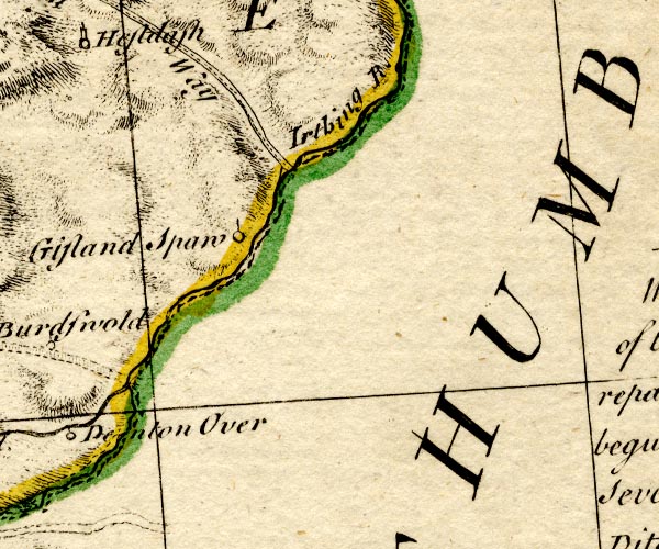 BO18NY76.jpg triple line, solid dotted solid item:- Armitt Library : 2008.14.10 Image © see bottom of page |
|
|
|
||
| evidence:- | old map:- Donald 1774 (Cmd) placename:- Maiden Way |
|
| source data:- | Map, hand coloured engraving, 3x2 sheets, The County of Cumberland, scale about 1
inch to 1 mile, by Thomas Donald, engraved and published by Joseph Hodskinson, 29
Arundel Street, Strand, London, 1774.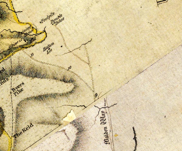 D4NY65NE.jpg "Maiden Way" 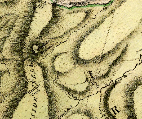 D4NY64SE.jpg 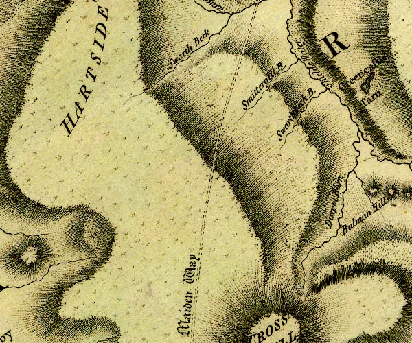 D4NY63NE.jpg "Maiden Way" double dotted line, track, labelled in English Black Letter item:- Carlisle Library : Map 2 Images © Carlisle Library |
|
|
|
||
| evidence:- | old text:- Camden 1789 placename:- Maiden Way item:- roman inscription; inscription, roman; roman coin; coin, roman |
|
| source data:- | Book, Britannia, or A Chorographical Description of the Flourishing Kingdoms of England,
Scotland, and Ireland, by William Camden, 1586, translated from the 1607 Latin edition
by Richard Gough, published London, 1789. goto source Page 148:- "... It [roman fort, Burwens] was certainly considerable when the pitched road called Maidenway ran strait from hence to Caer Vorran by the Picts' wall, where moorish mountains rear their heads for nearly 20 miles. On this way I should conclude the stations and mansions recited by Antoninus in his IXth British iter lay if nobody had pointed out the places. ..." |
|
|
|
||
| evidence:- | old text:- Camden 1789 (Gough Additions) placename:- |
|
| source data:- | Book, Britannia, or A Chorographical Description of the Flourishing Kingdoms of England,
Scotland, and Ireland, by William Camden, 1586, translated from the 1607 Latin edition
by Richard Gough, published London, 1789. goto source Page 151:- "... Maiden way, so called perhaps from Maiden castle a small fort at the first entrance over Stanemore, branched out from the other (roman road, Brough to Brougham] at Kirkby Thore, stretching northwards over the low end of Cross fell to where it joined with the Picts wall in Northumberland. ..." |
|
|
|
||
| evidence:- | old text:- Gents Mag |
|
| source data:- | Magazine, The Gentleman's Magazine or Monthly Intelligencer or
Historical Chronicle, published by Edward Cave under the
pseudonym Sylvanus Urban, and by other publishers, London,
monthly from 1731 to 1922. goto source Gentleman's Magazine 1852 part 1 p.482 "..." "The Maiden Way is but doubtfully traceable in the northern vicinage of the camp; but southwards the remains of it are distinctly visible for a considerable distance, as it crosses the high grounds of Side Fell and Gillilee's Beacon. Under the guidance of the incumbent of the parish, we tracked the interesting work. When first met with, it is only to be distinguished by the "trail" of the stones that have composed it, most of the neighbouring fences having been made at its expence. For nearly a quarter of a mile it is in a perfect state, which is the more remarkable as all the neighbouring ground is a peaty bog." "After crossing the crown of the hill we came to what is undoubtedly the foundation of a Roman watch-tower. It stands close by the edge of the road on its western side. It is eighteen feet square, and has walls four feet thick. The doorway seems to have been on its north side. Its wall are formed of regular masonry; the stones possessing the characteristics of those uniformly employed in constructing the stations on the line of the Roman wall. If the rubbish were removed the building would probably stand five feet high. No one who is familiar with the masonry of the wall-district can for a moment doubt that it is of Roman construction. On the Watling-street - the Roman road which twenty miles to the east of this intersects the mural region from north to south - some traces of wayside towers have been noticed; but none, I believe, to be at all compared with this in distinctness. The Romans have had a more thorough grasp of the Lower Isthmus than we are apt to imagine. Besides the wall, which merely forms the base line of their operations, and the stations to the north and south of it, to intercept the progress of an enemy in either direction, there seems reason to believe that picket camps were planted on advanced points and beacon-towers stationed on the most elevated summits. The watch-tower which I have now described has a very extensive prospect in every direction except the north. The line of the wall is distinctly in view all the way from Sewingshields to the Solway. Signals could therefore be communicated with the stations of Borcovicus, AEsica, Amboglanna, and others to the west. The Maiden Way, in its progress south, is in view for miles. Even now its track can be clearly made out, as after having crossed the wall it boldly ascends the heathy heights of Knaresdale." "On the western slope of the hill on which this Roman turret stands are some earthworks which we took to be temporary camps. They are of limited size, and may have been occupied by the troops whilst superintending the construction of the road." |
|
|
|
||
Lakes Guides menu.