 Old Cumbria Gazetteer
 |
 |
|
| Preston Patrick Hall, Preston Patrick | ||
| Preston Patrick Hall | ||
| civil parish:- | Preston Patrick (formerly Westmorland) | |
| county:- | Cumbria | |
| locality type:- | buildings | |
| locality type:- | park | |
| coordinates:- | SD54438374 | |
| 1Km square:- | SD5483 | |
| 10Km square:- | SD58 | |
|
|
||
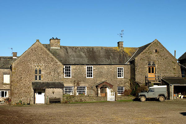 BQA68.jpg (taken 6.2.2009) 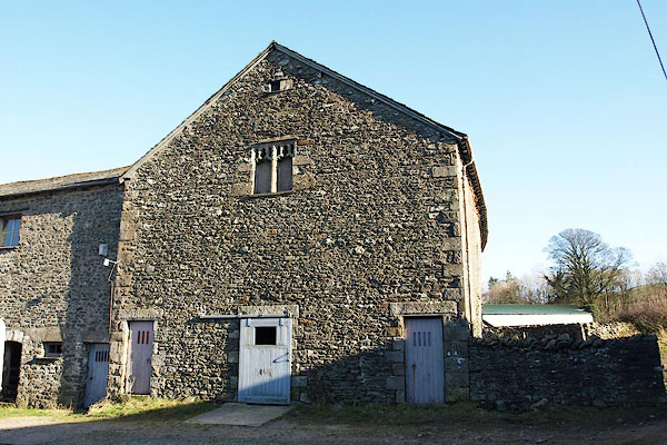 BQA69.jpg Barn to right of the hall. (taken 6.2.2009) |
||
|
|
||
| evidence:- | old map:- Jansson 1646 |
|
| source data:- | Map, hand coloured engraving, Cumbria and Westmoria, ie
Cumberland and Westmorland, scale about 3.5 miles to 1 inch, by
John Jansson, Amsterdam, Netherlands, 1646.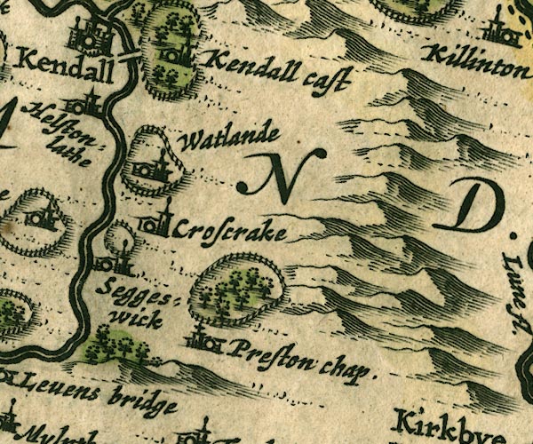 JAN3SD58.jpg Ring of fence palings with trees. item:- JandMN : 88 Image © see bottom of page |
|
|
|
||
| evidence:- | probably old map:- Morden 1695 (Wmd) placename:- Preston Hall |
|
| source data:- | Map, hand coloured engraving, Westmorland, scale about 2.5 miles to 1 inch, by Robert
Morden, published by Abel Swale, the Unicorn, St Paul's Churchyard, Awnsham, and John
Churchill, the Black Swan, Paternoster Row, London, 1695.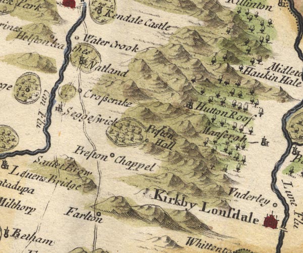 MD10SD58.jpg "Preston Hall" Circle, by a park - ring of fence palings, trees. item:- JandMN : 24 Image © see bottom of page |
|
|
|
||
| evidence:- | old map:- Badeslade 1742 placename:- Preston Hall |
|
| source data:- | Map, uncoloured engraving, A Map of Westmorland North from
London, scale about 10 miles to 1 inch, with descriptive text,
by Thomas Badeslade, London, engraved and published by William
Henry Toms, Union Court, Holborn, London, 1742. click to enlarge click to enlargeBD12.jpg "Preston Hall" circle, italic lowercase text; village, hamlet or locality item:- Dove Cottage : 2007.38.62 Image © see bottom of page |
|
|
|
||
| evidence:- | old map:- Simpson 1746 map (Wmd) placename:- Preston Hall |
|
| source data:- | Map, uncoloured engraving, Westmorland, scale about 8 miles to 1
inch, printed by R Walker, Fleet Lane, London, 1746. SMP2SDP.jpg "Preston Hall" Building in a park. item:- Dove Cottage : 2007.38.59 Image © see bottom of page |
|
|
|
||
| evidence:- | old map:- Bowen and Kitchin 1760 placename:- Preston Hall |
|
| source data:- | Map, hand coloured engraving, A New Map of the Counties of
Cumberland and Westmoreland Divided into their Respective Wards,
scale about 4 miles to 1 inch, by Emanuel Bowen and Thomas
Kitchin et al, published by T Bowles, Robert Sayer, and John
Bowles, London, 1760. BO18SD58.jpg "Preston Hall" circle and line by outline of fence palings item:- Armitt Library : 2008.14.10 Image © see bottom of page |
|
|
|
||
| evidence:- | old map:- Jefferys 1770 (Wmd) placename:- Preston Hall |
|
| source data:- | Map, 4 sheets, The County of Westmoreland, scale 1 inch to 1
mile, surveyed 1768, and engraved and published by Thomas
Jefferys, London, 1770. J5SD58SW.jpg "Preston Hall" circle, labelled in italic lowercase text; settlement, farm, house, or hamlet? item:- National Library of Scotland : EME.s.47 Image © National Library of Scotland |
|
|
|
||
| evidence:- | old photograph:- Bell 1880s-1940s placename:- Preston Hall |
|
| source data:- | Photograph, Preston Hall, Preston Patrick, Westmorland, by Herbert Bell, photographer,
Ambleside, Westmorland, 1897.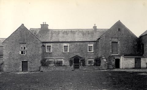 click to enlarge click to enlargeHB0177.jpg Vol.2 no.177 in an album, Examples of Early Domestic and Military Architecture in Westmorland, assembled 1910. ms at bottom:- "177. Preston Hall, Burton in Kendal. L." item:- Armitt Library : 1958.3166.71 Image © see bottom of page |
|
|
|
||
| evidence:- | old photograph:- Bell 1880s-1940s placename:- Preston Hall |
|
| source data:- | Photograph, Preston Hall, Preston Patrick, Westmorland, by Herbert Bell, photographer,
Ambleside, Westmorland, 1897.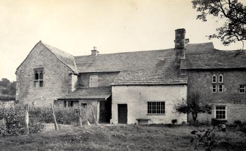 click to enlarge click to enlargeHB0178.jpg Vol.2 no.178 in an album, Examples of Early Domestic and Military Architecture in Westmorland, assembled 1910. ms at bottom:- "178. Preston Hall, Burton in Kendal. L." item:- Armitt Library : 1958.3166.72 Image © see bottom of page |
|
|
|
||
| evidence:- | site plan:- Historical Monuments 1936 placename:- Preston Patrick Hall |
|
| source data:- | Siteplan, uncoloured lithograph, Preston Patrick Hall, Preston Patrick, Westmorland,
scale about 1 to 290, published by Royal Commission on Historical Monuments England,
London, 1936.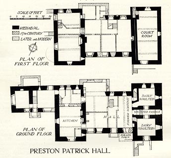 click to enlarge click to enlargeHMW117.jpg On p.196 of the Inventory of the Historical Monuments in Westmorland. printed, bottom "PRESTON PATRICK HALL" RCHME no. Wmd, Preston Patrick 3 item:- Armitt Library : A745.118 Image © see bottom of page |
|
|
|
||
| evidence:- | database:- Listed Buildings 2010 placename:- Preston Patrick Hall |
|
| source data:- | courtesy of English Heritage "PRESTON PATRICK HALL / / / PRESTON PATRICK / SOUTH LAKELAND / CUMBRIA / II[star] / 76607 / SD5443083748" |
|
|
|
||
| evidence:- | database:- Listed Buildings 2010 |
|
| source data:- | courtesy of English Heritage "BANK BARNS ATTACHED AT RIGHT-ANGLES TO EAST OF PRESTON PATRICK HALL / / / PRESTON PATRICK / SOUTH LAKELAND / CUMBRIA / II / 76608 / SD5446783730" |
|
|
|
||
| evidence:- | database:- Listed Buildings 2010 |
|
| source data:- | courtesy of English Heritage "WAGGON SHED AND BARN AT RIGHT ANGLES TO WEST OF PRESTON PATRICK HALL / / / PRESTON PATRICK / SOUTH LAKELAND / CUMBRIA / II / 76609 / SD5442183721" |
|
|
|
||
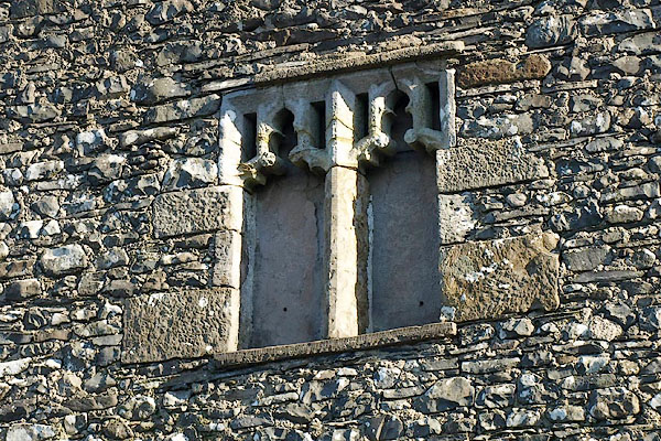 BQA70.jpg Window in barn to right of hall. (taken 6.2.2009) 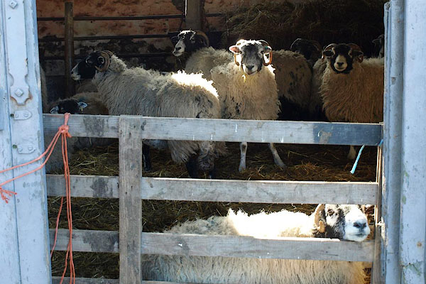 BQA71.jpg Swaledale sheep. (taken 6.2.2009) |
||
|
|
||
| notes:- |
two 15th century towers |
|
| Perriam, D R &Robinson, J: 1998: Medieval Fortified Buildings of Cumbria: CWAAS::
ISBN 1 873124 23 6; plan and illustrations |
||
|
|
||
| hearsay:- |
The manor courts were held here. |
|
| Many Quakers brought here for their transgressions. One of them, Thomas Camm of Camsgill,
was distrained thirty three times for non payment of tithes in the period 1683 to
1690, paying fines totalling £62 12s 8d. |
||
| Palmer 1945 |
||
|
|
||
 Lakes Guides menu.