 Old Cumbria Gazetteer
 |
 |
|
| milestone, Cartmel (2) | ||
| site name:- | road, Kents Bank to Sand Gate | |
| locality:- | Cartmel | |
| civil parish:- | Lower Allithwaite (formerly Lancashire) | |
| county:- | Cumbria | |
| locality type:- | milestone | |
| locality type:- | guide stone | |
| coordinates:- | SD37997836 | |
| 1Km square:- | SD3778 | |
| 10Km square:- | SD37 | |
|
|
||
 BLU46.jpg (taken 7.4.2006) 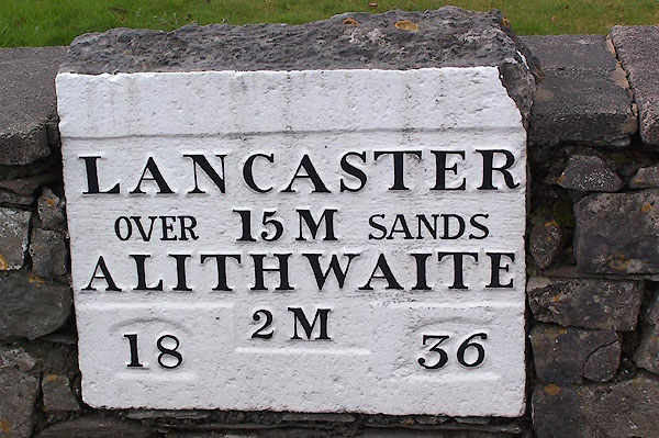 BLU47.jpg (taken 7.4.2006) |
||
|
|
||
| evidence:- | old map:- OS County Series (Lan 17) |
|
| source data:- | Maps, County Series maps of Great Britain, scales 6 and 25
inches to 1 mile, published by the Ordnance Survey, Southampton,
Hampshire, from about 1863 to 1948. "ULVERSTON 7 LANCASTER 15 M.S." |
|
|
|
||
| evidence:- | database:- Listed Buildings 2010 |
|
| source data:- | courtesy of English Heritage "GUIDE STONE APPROXIMATELY 7 METRES FROM JUNCTION AT HEADLESS CROSS / / TEMPLAND ROAD / LOWER ALLITHWAITE / SOUTH LAKELAND / CUMBRIA / II / 77024 / SD3800278357" |
|
| source data:- | courtesy of English Heritage "Milestone. 1836. Stone rectangular slab set into stone wall. Panel has raised lettering reading: "LANCASTER/15M/ALITHHAITE/2M". 2 small panels have figures "18" and "36"." |
|
|
|
||
| evidence:- | database:- Listed Buildings 2010 |
|
| source data:- | courtesy of English Heritage "GUIDESTONE APPPROXIMATELY 7 METRES SOUTH WEST OF JUNCTION WITH TEMPLANDS ROAD / / / LOWER ALLITHWAITE / SOUTH LAKELAND / CUMBRIA / II / 76970 / SD3798678366" |
|
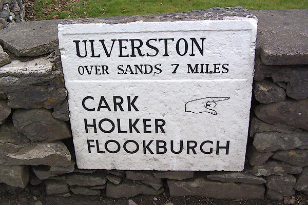
| source data:- | courtesy of English Heritage "Milestone. c1836. Stone. Rectangular slab set into stone wall. Top panel reads: "ULVERSTON/OVER SANDS 7 MILES"; lettering below reads: "CARK/HOLKER/ FLOOKBURGH"." |
|
|
|
||
 Lakes Guides menu.