 Old Cumbria Gazetteer
 |
 |
|
| roman fort, Ambleside | ||
| Galava | ||
| Street:- | Borrans Road | |
| locality:- | Borrans Field | |
| locality:- | Waterhead | |
| locality:- | Ambleside | |
| civil parish:- | Lakes (formerly Westmorland) | |
| county:- | Cumbria | |
| locality type:- | roman fort | |
| coordinates:- | NY37250342 | |
| 1Km square:- | NY3703 | |
| 10Km square:- | NY30 | |
| SummaryText:- | Built to guard the roman road from Brougham to Ravenglass, 1st century. | |
|
|
||
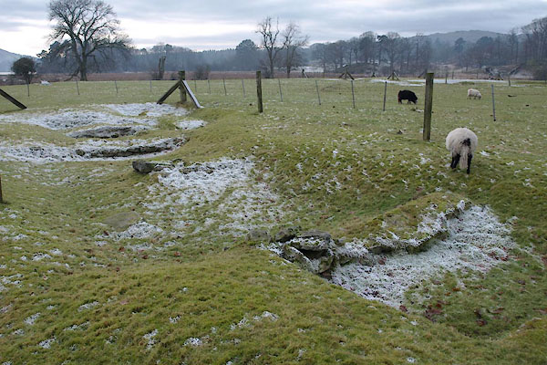
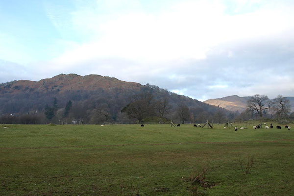 BTY02.jpg The site does not catch the eye. (taken 22.1.2011) |
||
|
|
||
| evidence:- | old map:- OS County Series (Wmd 26 10) placename:- Dictis |
|
| source data:- | Maps, County Series maps of Great Britain, scales 6 and 25
inches to 1 mile, published by the Ordnance Survey, Southampton,
Hampshire, from about 1863 to 1948. |
|
|
|
||
| evidence:- | descriptive text:- Keer 1605 (edn 1620) placename:- Amboglana |
|
| source data:- | Map, Westmorlandia et Comberlandia, ie Westmorland and
Cumberland now Cumbria, scale about 16 miles to 1 inch, probably
by Pieter van den Keere, or Peter Keer, about 1605, published
about 1605 to 1676. goto source goto sourcethird page "(10) Other matters worthy observation are onely these: That at Amboglana, now called Am-" goto sourcefourth page "[Am]ble-side, neere the upper corner of Winander mear, there appeares at this day the ruines of an ancient Citie, which by the British-Brickes, by Romane-money oftentimes found there, by High-wayes paved leading unto it, and other likelihoods, seemes to have beene a worke of the Romanes: the Fortresse thereof so long fenced with a ditch and rampire, that it took up in length one hundred thirtie two Ells, and in bredth eight. ..." |
|
|
|
||
| evidence:- | old map:- Pennant 1777 placename:- Dictis |
|
| source data:- | Map, hand coloured engraving, A Map of Scotland, Hebrides and
Part of England, drawn for Thomas Pennant, engraved by J Bayly,
published by Benjamin White, London, 1777. click to enlarge click to enlargePEN1Cm.jpg "DICTIS / Ambleside" circle; buildings, village, etc item:- private collection : 66 Image © see bottom of page |
|
|
|
||
| evidence:- | descriptive text:- West 1778 (11th edn 1821) placename:- Dictis |
|
| source data:- | Guide book, A Guide to the Lakes, by Thomas West, published by
William Pennington, Kendal, Cumbria once Westmorland, and in
London, 1778 to 1821. goto source Page 75:- "Just at the head of Windermere, and a little short of Ambleside, turn down a bye-road to the left, and see the vestige of a Roman station. It lies in a meadow, on a level with the lake, and, as supposed, was called the Dictis, where a part of the cohort Nerviorum Dictenium was stationed. It is placed near the meetings of all the roads from Penrith, Keswick, Ravenglass, Furness, and Kendal, which it commanded, and was accessible only on one side." "..." "Here nothing at present is found of all that Camden mentions of this place. So swift is" goto sourcePage 76:- "time in destroying the last remains of ancient magnificence! Roman coins and arms have been frequently found here; and, in forming the turnpike-road through Rydal, an urn was lately taken up, which contained ashes and other Roman remains, and serves to prove that the tract of the ancient road laid that way." "..." goto sourcePage 151:- "... At Ambleside, when I enquired for the Roman station, a few years ago, no person could inform me of it, till one considering my description, answered, it is the castle. ..." |
|
|
|
||
| evidence:- | old map:- West 1784 map |
|
| source data:- | Map, hand coloured engraving, A Map of the Lakes in Cumberland,
Westmorland and Lancashire, scale about 3.5 miles to 1 inch,
engraved by Paas, 53 Holborn, London, about 1784. Ws02NY30.jpg "Camp" item:- Armitt Library : A1221.1 Image © see bottom of page |
|
|
|
||
| evidence:- | old text:- Clarke 1787 placename:- Amboglana placename:- Castle, The item:- roman coin; coin, roman; roman altar; altar, roman |
|
| source data:- | Guide book, A Survey of the Lakes of Cumberland, Westmorland,
and Lancashire, written and published by James Clarke, Penrith,
Cumberland, and in London etc, 1787; published 1787-93. goto source Page 131:- "..." "CAMBDEN says, "At the upper corner of Winandermere lieth the dead carcase of an ancient city, with great ruins of walls, and many heaps of rubbish, one from another, remaining of buildings without the walls, yet to be seen. The fortress thereof was somewhat long, fenced with a ditch and rampire, took up in length 132 ells, and breadth 80. That it has been the Romans work is evident by the British bricks, by the mortar tempered with little pieces of brick among it, by small earthen pots or pitchers, by small cruets or vials of glass, by pieces of Roman money oftentimes found, and by round stones as big as millstones or quernstones, of which laid and couched together they framed, in old times, their columns, and by the paved ways leading to it. Now the ancient name thereof is gone, unless a man would guess at it, and think it were that Amboglana, whereof the book of notices maketh mention, seeing at this day it is called Ambleside."" "By some stones found on Agricola's wall since Cambden's time, it appears Amboglana was there; the stones are now at Naworth Castle. The cohort might be first established at the Picts wall, and a part of them remove hither and give it their name; for Guthrie says, "under the Honourable the Duke of Britain was placed the prefect of a detachment of the Nervii called Dictenses at Ambleside."" "The fort lyes a little below the town; the remains of it are now very small, but many coins have been found there; and in the year 1785, a man planting potatoes with the spade there, found a crucifix of brass, which was given me. The inhabitants dug up, not many years ago, several pieces, (as they called them) of free stone, which probably had been altars or the pedestals of Pillars. As there is no free stone within twenty-five miles of the place, I should think they were brought hither for urns, fonts, or some purpose of that kind, as the blue ragg, or granite stones found here, cannot be worked with a chissel: Had any Antiquarian been there, some things perhaps might have led to a more perfect discovery, but they were generally broken small for scowring sand, which is a scarce article at Ambleside. That it was a Roman station is, I think, beyond a doubt: it is by the inhabitants called the Castle, and I should suppose that this castle or fort was of some account in the year 794, and was the place where the two sons of Elfwold were decoyed to before they were murdered, and not Bowness, as Cambden has conjectured: All the old authors agree that they were murdered at Winandermere, and I should suppose this was the only place of note in 794 within the parish called Winandermere." "..." goto sourcePage 132:- "..." "There was formerly a family of the name of Brathwaites here [Ambleside] ... The last Thomas Brathwaite of Ambleside had a large collection of Roman coins, which he and his ancestors had got from the old fort (or castle,) and another place called the Borrans, a square fort, more remains of which may be seen than of the other. There were, says Mr Machel, who had seen those coins, "6 of gold, 66 of silver, and 250 others." He left them by his will to the University of Oxford; but his will being made void for want of form, (at the instigation of Brathwaite Otway) they continued in the family, and came into the possession of the Countess of Litchfield." |
|
|
|
||
| evidence:- | old text:- Camden 1789 (Gough Additions) item:- roman finds |
|
| source data:- | Book, Britannia, or A Chorographical Description of the Flourishing Kingdoms of England,
Scotland, and Ireland, by William Camden, 1586, translated from the 1607 Latin edition
by Richard Gough, published London, 1789. goto source Page 144:- "..." "At the head of the lake [Windermere], and level with it, not far from Ambleside, is a Roman fort, single ditch, 396 feet by 240 the shortest side next the water, in which have been found Roman antiquities, though its name cannot be ascertained." |
|
|
|
||
| evidence:- | old text:- Camden 1789 (Gough Additions) placename:- Dictis item:- roman coin; coin, roman |
|
| source data:- | Book, Britannia, or A Chorographical Description of the Flourishing Kingdoms of England,
Scotland, and Ireland, by William Camden, 1586, translated from the 1607 Latin edition
by Richard Gough, published London, 1789. goto source Page 155:- "..." "At the upper corner of Windermere water, not far from the present town of Ambleside, lies the carcase of an antient city with large ruins of walls, and without the walls the rubbish of old buildings in many places: adjoining to which and opening to the water has been a fort of an oblong figure 165 by 100 yards, fortified with a ditch and rampart. Pieces of bricks, little urns, glass phials, Roman coins, round stones like mill-stones, of which soldered together they were wont to make pillars (for hypocausts, and the paved ways leading to it, are undeniable testimonies of its being a work of the Romans. And to this place Mr. Horsley supposes the military ways to have gone which pass by Pap castle and through Graystock park. This fort is guarded on the west by the conflux of the rivers Rowthey and Brathey, on the south by Windermere, a high rock at a small distance intercepted the north wind, and being fortified with a ditch and rampart it was only accessible from the south-east." "Mr. Ward supposed the name of this station DICTIS, and removed AMBOGLANA to Burdoswald, it being placed by the Notitia ad lineam valli. Among other pieces of antiquity discovered in this fort, were several Roman coins in all metals, which make part of the cabinet given by deed 1674 by Mr. Thomas Brathwate to the university of Oxford, many of them found in Barran's ring, a square fort in this lordship." |
|
|
|
||
| evidence:- | old text:- Camden 1789 placename:- Amboglana |
|
| source data:- | Book, Britannia, or A Chorographical Description of the Flourishing Kingdoms of England,
Scotland, and Ireland, by William Camden, 1586, translated from the 1607 Latin edition
by Richard Gough, published London, 1789. goto source Page 147:- "..." "At the upper point of Winandermere lies the carcase as it were of an antient city with great ruins of walls and of buildings without the walls still remaining scattered about. It was of an oblong form defended by a fosse and vallum, in length 132 ells and in breadth 80. The British bricks, the mortar mixed with fragments of bricks, the small urns, glass vessels, Roman coins frequently found, round stone like mill-stones, of which piled on one another pillars were formerly made, and the paved roads leading to it plainly bespeak it a Roman work. Its antient name indeed is lost unless as it is at present called Ambleside any one should suppose it the AMBOGLANA of the Notitia." |
|
|
|
||
| evidence:- | descriptive text:- Farington 1789 (plate 16) placename:- Dictis item:- roman brick; brick, roman; urn; potsherds, roman; roman coin; coin, roman; quern stone |
|
| source data:- | Set of prints, 20 engravings, Views of the Lakes etc in Cumberland and Westmorland,
drawn by Joseph Farington, published by William Byrne, 79 Titchfield Street, London,
1789. Descriptive text with a print, View of Ambleside, Lakes, Cumbria, painted by Joseph Farington, engraved by T Medland, published by W Byrne, 69 Titchfield Street, London, 1789:- "... Near the Head of Windermere, ... is the vestige of a Roman Station. It lies in a Meadow on a Level with the Lake, and, as supposed, was called the Dictis, where a Part of the Cohort of the Numerus Dictentium was stationed. The Extent of the Fortress, as he gives Dimensions, was one hundred and thirty-two Ells in Length and eighty in Breadth. Its Form an oblong Square with obtuse Angles. It is placed near the Meeting of all the Roads from Penrith, Keswick, Ravenglass, Furness and Kendal, which it commanded, and was accessible only on one Side. Roman Bricks, Urns, and other earthen Vessels, Coins, Mill-Stones or Quern-Stones, as he calls them, were frequently found here. ..." |
|
|
|
||
| evidence:- | old text:- Capper 1808 placename:- Dictus |
|
| source data:- | Gazetteer, A Topographical Dictionary of the United Kingdom,
compiled by Benjamin Pitts Capper, published by Richard
Phillips, Bridge Street, Blackfriars, London, 1808; published
1808-29. goto source "... The town itself [Ambleside] was formerly a city, built by the Romans after the reduction of the Brigantes. Horsley says it was called Dictus. ..." |
|
|
|
||
| evidence:- | descriptive text:- Ford 1839 (3rd edn 1843) |
|
| source data:- | Guide book, A Description of Scenery in the Lake District, by
Rev William Ford, published by Charles Thurnam, Carlisle, by W
Edwards, 12 Ave Maria Lane, Charles Tilt, Fleet Street, William
Smith, 113 Fleet Street, London, by Currie and Bowman,
Newcastle, by Bancks and Co, Manchester, by Oliver and Boyd,
Edinburgh, and by Sinclair, Dumfries, 1839. goto source Page 32:- "..." "[Ambleside] ... was formerly the site of a Roman station; ruined wall and traces of fortifications are discernible, and armour and coins have been found. ..." |
|
|
|
||
| evidence:- | old photograph:- Bell 1880s-1940s |
|
| source data:- | Photograph, head of lake Windermere, by Herbert Bell, Ambleside, Westmorland, 1890s?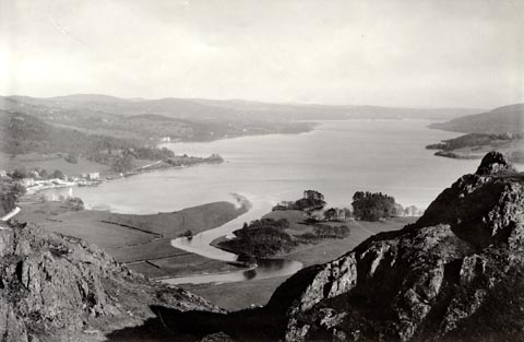 click to enlarge click to enlargeHB0252.jpg Waterhead bay on the left; the roman fort site and Borrans Park left of centre. item:- Armitt Library : ALPS650 Image © see bottom of page |
|
|
|
||
| evidence:- | descriptive text:- Palmer 1926 |
|
| source data:- | Guide book, Things Seen at the English Lakes, by William T
Palmer, published by Seeley, Service and Co, 196 Shaftesbury
Avenue, London, 1926. "... Though Camden gloridfied the camp as the carcass of a mighty city, the spade has given no direct evidence of either period or name. An old sandal seems to be the most distinctive find. It is not intended to decry the camp and its investgators. To the ordinary visitor it must be confessed that no remarkable thing is at present visible. ... there is no harm in looking round. ..." |
|
|
|
||
| evidence:- | site plan:- Historical Monuments 1936 |
|
| source data:- | Site plan, uncoloured lithograph, Ambleside, Roman Forts, Westmorland, scale about
1 to 1300, published by Royal Commission on Historical Monuments England, London,
1936.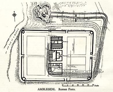 click to enlarge click to enlargeHMW003.jpg On p.2 of the Inventory of the Historical Monuments in Westmorland. printed, bottom "AMBLESIDE. Roman Forts" RCHME no. Wmd, Ambleside 1 item:- Armitt Library : A745.3 Image © see bottom of page |
|
|
|
||
| evidence:- | textbook:- Rivet and Smith 1979 placename:- Galava placename:- Calunio placename:- Caluuio placename:- Colunio placename:- Galunio placename:- Galluio |
|
| source data:- | The roman fort at Ambleside, Westmorland, on the River Brathay. |
|
|
|
||
| evidence:- | database:- Listed Buildings 2010 placename:- Galava |
|
| source data:- | courtesy of English Heritage "BORRAN'S FIELD (GALAVA ROMAN FORT) / / / LAKES / SOUTH LAKELAND / CUMBRIA / I / 450573 / NY3718203423" |
|
| source data:- | courtesy of English Heritage "National Trust. Remains of 2 Roman forts of different dates, with granaries etc. On splendid site in open field on lake edge, now a public open space." |
|
|
|
||
| evidence:- | old map:- Horsley 1732 placename:- Dictis placename:- Ambleside |
|
| source data:- | Map, uncoloured engraving, Britannia Antiqua, roman Britain,
scale about 50 miles to 1 inch, by John Horsley, perhaps 1732,
edition published about 1869? click to enlarge click to enlargeHOR1Cm.jpg "Dictis / Ambleside" item:- JandMN : 429 Image © see bottom of page |
|
|
|
||
| evidence:- | old print:- placename:- Amboglana item:- roman |
|
| source data:- | Print, uncoloured engraving, North East Gateway of the Station of Amboglana, 180s-90s?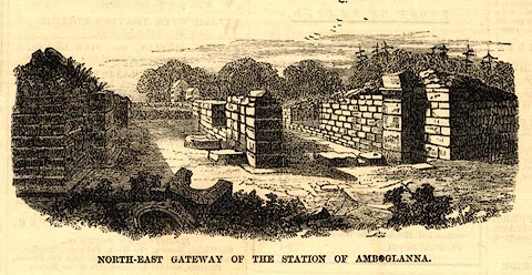 click to enlarge click to enlargePR0662.jpg printed at bottom:- "NORTH-EAST GATEWAY OF THE STATION OF AMBOGLANA" item:- Dove Cottage : 2008.107.603 Image © see bottom of page |
|
|
|
||
 BTY03.jpg Porta praetoria, main gate (taken 22.1.2011) 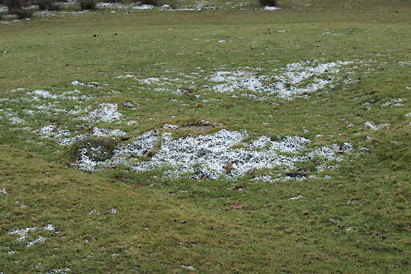 BTY04.jpg Angle tower. (taken 22.1.2011) 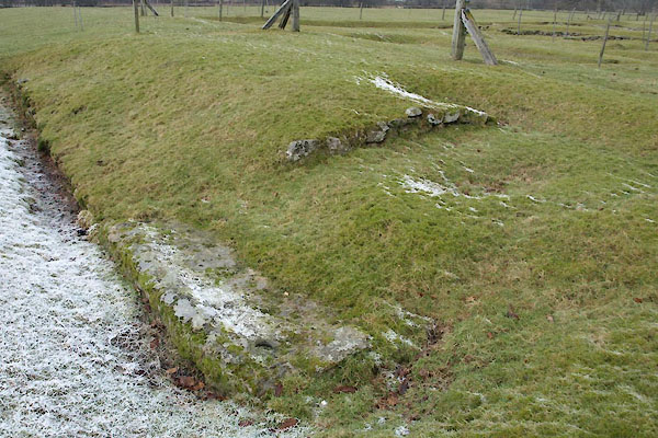 BTY05.jpg Porta principalis, south gate. (taken 22.1.2011) 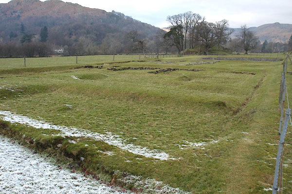 BTY06.jpg Praetorium. (taken 22.1.2011) 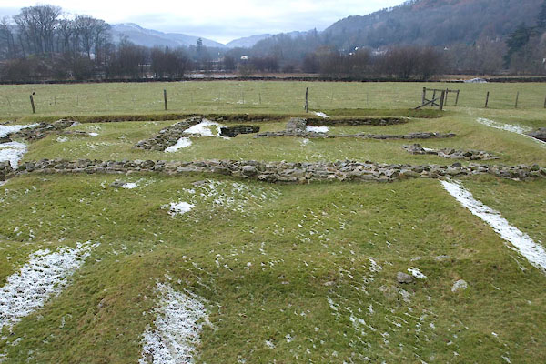 BTY07.jpg Principia. (taken 22.1.2011) 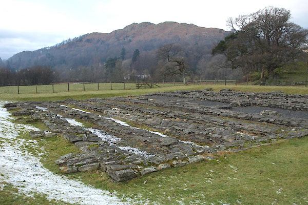 BTY08.jpg Horrea, granaries. (taken 22.1.2011) |
||
|
|
||
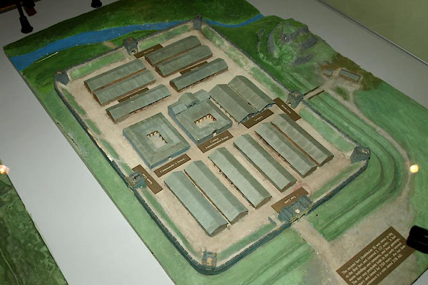 BTX64.jpg Collingood's reconstruction of the fort. courtesy of the Armitt Library 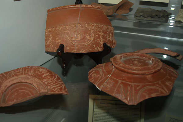 BTX65.jpg Samian ware from the fort. courtesy of the Armitt Library 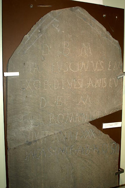 BTX66.jpg Gravestone excavated at Galava. courtesy of the Armitt Library |
||
|
|
||
| hearsay:- |
A gravestone found on the site (in Kendal Museum):- |
|
| "To the good gods of the underworld / Flavius Fuscinus retired / from the Centurionship
/ Lived 55 years: / To the good gods of the underworld / Flavius Romanus, record clerk
/ lived for 35 years / Killed in the fort by the enemy." |
||
|
|
||
| person:- | : English Heritage |
|
|
|
||
Lakes Guides menu.