 Old Cumbria Gazetteer
 |
 |
|
| Roper Castle, Stainmore | ||
| Roper Castle | ||
| Round Table | ||
| civil parish:- | Stainmore (formerly Westmorland) | |
| county:- | Cumbria | |
| locality type:- | roman signal station | |
| locality type:- | signal station | |
| coordinates:- | NY88221115 | |
| 1Km square:- | NY8811 | |
| 10Km square:- | NY81 | |
|
|
||
| evidence:- | old map:- OS County Series (Wmd 24) placename:- Roper Castle placename:- Round Table |
|
| source data:- | Maps, County Series maps of Great Britain, scales 6 and 25
inches to 1 mile, published by the Ordnance Survey, Southampton,
Hampshire, from about 1863 to 1948. "Roper Castle or Round Table" |
|
|
|
||
| evidence:- | site plan:- Historical Monuments 1936 placename:- Roper Castle |
|
| source data:- | Site plan, uncoloured lithograph, Roper Castle, Stainmore, Westmorland, scale about
1 to 530, published by Royal Commission on Historical Monuments England, London, 1936.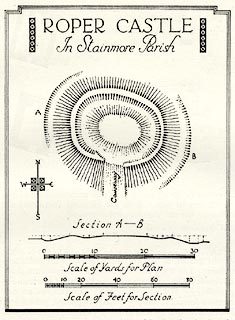 click to enlarge click to enlargeHMW129.jpg On p.217 of the Inventory of the Historical Monuments in Westmorland. printed, top "ROPER CASTLE / In Stainmore parish" RCHME no. Wmd, Stainmore 18 item:- Armitt Library : A745.130 Image © see bottom of page |
|
|
|
||
 Lakes Guides menu.