 Old Cumbria Gazetteer
 |
 |
|
| Salt Well Mines, Borrowdale | ||
| Salt Well Mines | ||
| site name:- | Park Neb | |
| civil parish:- | Borrowdale (formerly Cumberland) | |
| county:- | Cumbria | |
| locality type:- | copper mine | |
| locality type:- | lead mine | |
| locality type:- | mine | |
| coordinates:- | NY255189 | |
| 1Km square:- | NY2518 | |
| 10Km square:- | NY21 | |
| references:- | Adams, John: 1988: Mines of the Lake District Fells: Dalesman Books (Lancaster, Lancashire)::
ISBN 0 85206 931 6 |
|
|
|
||
| evidence:- | old map:- Crosthwaite 1783-94 (Der) |
|
| source data:- | Map, uncoloured engraving, An Accurate Map of the Matchless Lake
of Derwent, ie Derwent Water, scale about 3 inches to 1 mile, by
Peter Crosthwaite, Keswick, Cumberland, 1783, version published
1800.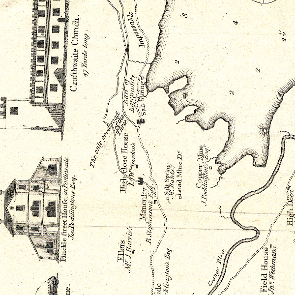 CT2NY21N.jpg "Lead Mine / Do. [Mr Banks's]" item:- Armitt Library : 1959.191.3 Image © see bottom of page |
|
|
|
||
| evidence:- | old map:- Crosthwaite 1783-94 (Der) |
|
| source data:- | Map, uncoloured engraving, An Accurate Map of the Matchless Lake
of Derwent, ie Derwent Water, scale about 3 inches to 1 mile, by
Peter Crosthwaite, Keswick, Cumberland, 1783, version published
1800. CT2NY21N.jpg "Copper Mine / J. Pocklington's Esq." item:- Armitt Library : 1959.191.3 Image © see bottom of page |
|
|
|
||
| evidence:- | perhaps descriptive text:- Otley 1823 (5th edn 1834) item:- geology |
|
| source data:- | Guide book, A Concise Description of the English Lakes, the
mountains in their vicinity, and the roads by which they may be
visited, with remarks on the mineralogy and geology of the
district, by Jonathan Otley, published by the author, Keswick,
Cumberland now Cumbria, by J Richardson, London, and by Arthur
Foster, Kirkby Lonsdale, Cumbria, 1823; published 1823-49,
latterly as the Descriptive Guide to the English Lakes. goto source goto sourcePage 154:- "... Veins of lead ore occur in several places; and have been worked between Skiddaw and Saddleback, in Thornthwaite, Newlands, and Buttermere; but one in the parish of Loweswater, and one below the level of Derwent Lake, are the most productive at present in this district." |
|
|
|
||
| evidence:- | old map:- Postlethwaite 1877 (3rd edn 1913) placename:- Salt Well Park Mine |
|
| source data:- | Map, uncoloured engraving, Map of the Lake District Mining Field, Westmorland, Cumberland,
Lancashire, scale about 5 miles to 1 inch, by John Postlethwaite, published by W H
Moss and Sons, 13 Lowther Street, Whitehaven, Cumberland, 1877 edn 1913.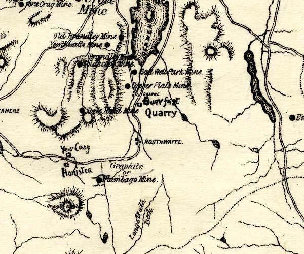 PST2NY21.jpg "Salt Well Park Mine" mine symbol item:- JandMN : 162.2 Image © see bottom of page |
|
|
|
||
| :- |
Group of small mines on the Salt Well Vein. |
|
| Adams, John: 1988: Mines of the Lake District Fells: Dalesman Books (Lancaster, Lancashire)::
ISBN 0 85206 931 6 |
||
|
|
||
Lakes Guides menu.