 Old Cumbria Gazetteer
 |
 |
|
| Selside Hall, Whitwell and Selside | ||
| Selside Hall | ||
| Street:- | Firtree Lane | |
| locality:- | Selside | |
| civil parish:- | Whitwell and Selside (formerly Westmorland) | |
| county:- | Cumbria | |
| locality type:- | buildings | |
| locality type:- | haunted house | |
| coordinates:- | SD53459904 | |
| 1Km square:- | SD5399 | |
| 10Km square:- | SD59 | |
|
|
||
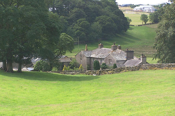 BMK05.jpg (taken 12.7.2006) |
||
|
|
||
| evidence:- | old map:- OS County Series (Wmd 34 5) placename:- Selside Hall |
|
| source data:- | Maps, County Series maps of Great Britain, scales 6 and 25
inches to 1 mile, published by the Ordnance Survey, Southampton,
Hampshire, from about 1863 to 1948. |
|
|
|
||
| evidence:- | old map:- Saxton 1579 placename:- Selsted Hall |
|
| source data:- | Map, hand coloured engraving, Westmorlandiae et Cumberlandiae Comitatus ie Westmorland
and Cumberland, scale about 5 miles to 1 inch, by Christopher Saxton, London, engraved
by Augustinus Ryther, 1576, published 1579-1645.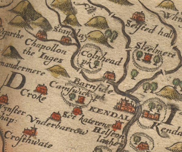 Sax9SD49.jpg Building, symbol for a hamlet, which may or may not have a nucleus. "Selsted hall" item:- private collection : 2 Image © see bottom of page |
|
|
|
||
| evidence:- | old map:- Speed 1611 (Wmd) placename:- Selsted Hall |
|
| source data:- | Map, hand coloured engraving, The Countie Westmorland and
Kendale the Cheif Towne, scale about 2.5 miles to 1 inch, by
John Speed, 1610, published by George Humble, Popes Head Alley,
London, 1611-12.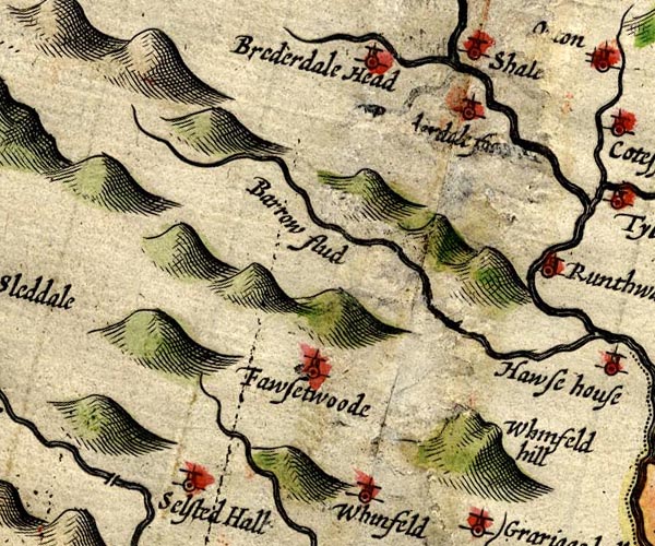 SP14NY50.jpg "Selsted Hall" circle, tower item:- Armitt Library : 2008.14.5 Image © see bottom of page |
|
|
|
||
| evidence:- | old map:- Jansson 1646 placename:- Selstedhall |
|
| source data:- | Map, hand coloured engraving, Cumbria and Westmoria, ie
Cumberland and Westmorland, scale about 3.5 miles to 1 inch, by
John Jansson, Amsterdam, Netherlands, 1646.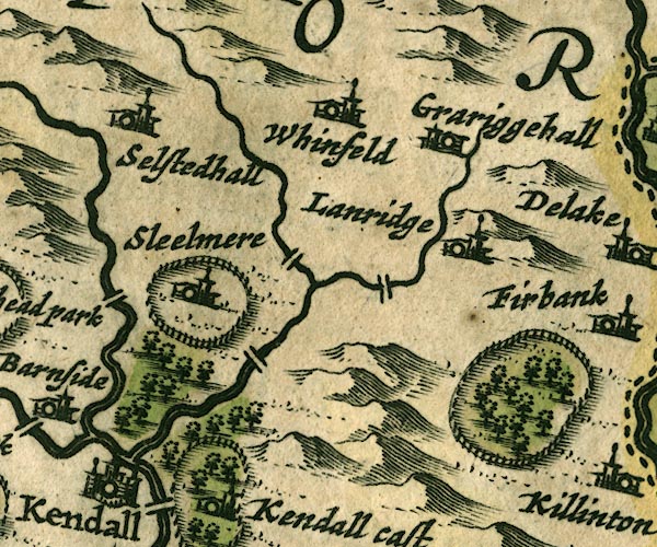 JAN3SD59.jpg "Selstedhall" Buildings and tower. item:- JandMN : 88 Image © see bottom of page |
|
|
|
||
| evidence:- | old map:- Seller 1694 (Wmd) placename:- Selsted Hall |
|
| source data:- | Map, hand coloured engraving, Westmorland, scale about 8 miles
to 1 inch, by John Seller, 1694. click to enlarge click to enlargeSEL7.jpg "Selsted hall" circle, italic lowercase text; settlement or house item:- Dove Cottage : 2007.38.87 Image © see bottom of page |
|
|
|
||
| evidence:- | old map:- Morden 1695 (Wmd) placename:- Selside Hall |
|
| source data:- | Map, hand coloured engraving, Westmorland, scale about 2.5 miles to 1 inch, by Robert
Morden, published by Abel Swale, the Unicorn, St Paul's Churchyard, Awnsham, and John
Churchill, the Black Swan, Paternoster Row, London, 1695.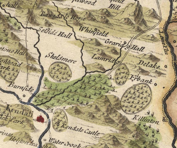 MD10SD59.jpg "Selside Hall" Circle. item:- JandMN : 24 Image © see bottom of page |
|
|
|
||
| evidence:- | old map:- Badeslade 1742 placename:- Selsted Hall |
|
| source data:- | Map, uncoloured engraving, A Map of Westmorland North from
London, scale about 10 miles to 1 inch, with descriptive text,
by Thomas Badeslade, London, engraved and published by William
Henry Toms, Union Court, Holborn, London, 1742. click to enlarge click to enlargeBD12.jpg "Selsted Hall" circle, italic lowercase text; village, hamlet or locality item:- Dove Cottage : 2007.38.62 Image © see bottom of page |
|
|
|
||
| evidence:- | probably old map:- Simpson 1746 map (Wmd) placename:- Selsted Hall |
|
| source data:- | Map, uncoloured engraving, Westmorland, scale about 8 miles to 1
inch, printed by R Walker, Fleet Lane, London, 1746.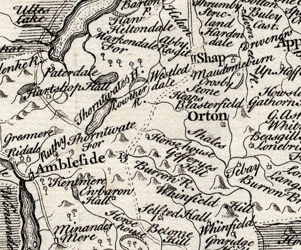 SMP2NYK.jpg "Selsted Hall" Building. item:- Dove Cottage : 2007.38.59 Image © see bottom of page |
|
|
|
||
| evidence:- | old map:- Bowen and Kitchin 1760 placename:- Solsted Hall |
|
| source data:- | Map, hand coloured engraving, A New Map of the Counties of
Cumberland and Westmoreland Divided into their Respective Wards,
scale about 4 miles to 1 inch, by Emanuel Bowen and Thomas
Kitchin et al, published by T Bowles, Robert Sayer, and John
Bowles, London, 1760.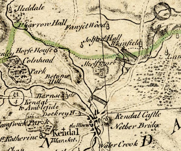 BO18SD49.jpg "Solsted Hall" circle and flag? item:- Armitt Library : 2008.14.10 Image © see bottom of page |
|
|
|
||
| evidence:- | old map:- Jefferys 1770 (Wmd) placename:- Sellside Hall |
|
| source data:- | Map, 4 sheets, The County of Westmoreland, scale 1 inch to 1
mile, surveyed 1768, and engraved and published by Thomas
Jefferys, London, 1770.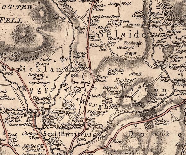 J5SD59NW.jpg "Sellside Hall" circle, labelled in italic lowercase text; settlement, farm, house, or hamlet? item:- National Library of Scotland : EME.s.47 Image © National Library of Scotland |
|
|
|
||
| evidence:- | old map:- Cary 1789 (edn 1805) placename:- Sellside Hall |
|
| source data:- | Map, uncoloured engraving, Westmoreland, scale about 2.5 miles
to 1 inch, by John Cary, London, 1789; edition 1805.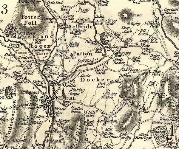 CY24SD59.jpg "Sellside Hall" block/s, labelled in italic lowercase; house, or hamlet item:- JandMN : 129 Image © see bottom of page |
|
|
|
||
| evidence:- | old photograph:- Bell 1880s-1940s placename:- Selside Hall |
|
| source data:- | Photograph, Selside Hall, Whitwell and Selside, Westmorland, by Herbert Bell, photographer,
Ambleside, Westmorland, 1895.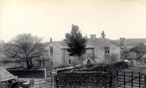 click to enlarge click to enlargeHB0163.jpg Vol.2 no.163 in an album, Examples of Early Domestic and Military Architecture in Westmorland, assembled 1910. ms at bottom:- "163. Selside Hall. Kendal. K." item:- Armitt Library : 1958.3166.57 Image © see bottom of page |
|
|
|
||
| evidence:- | site plan:- Historical Monuments 1936 placename:- Selside Hall |
|
| source data:- | Site plan, uncoloured lithograph, Selside Hall, Whitwell and Selside, Westmorland,
scale about 1 to 290, published by Royal Commission on Historical Monuments England,
London, 1936.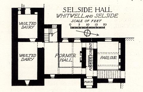 click to enlarge click to enlargeHMW143.jpg On p.244 of the Inventory of the Historical Monuments in Westmorland. printed, upper right "SELSIDE HALL / WHITWELL AND SELSIDE" RCHME no. Wmd, Whitwell and Selside 5 item:- Armitt Library : A745.144 Image © see bottom of page |
|
|
|
||
| evidence:- | database:- Listed Buildings 2010 placename:- Selside Hall |
|
| source data:- | courtesy of English Heritage "SELSIDE HALL AND ATTACHED OUTBUILDING / / FIRTREE LANE / WHITWELL AND SELSIDE / SOUTH LAKELAND / CUMBRIA / II[star] / 75768 / SD5345999043" |
|
|
|
||
| evidence:- | database:- Listed Buildings 2010 |
|
| source data:- | courtesy of English Heritage "OUTBUILDING IMMEDIATELY TO SOUTH-EAST OF SELSIDE HALL / / FIRTREE LANE / WHITWELL AND SELSIDE / SOUTH LAKELAND / CUMBRIA / II / 75769 / SD5347699034" |
|
|
|
||
| hearsay:- |
Built 14th century, home of the Thornburgh Family. There is a priest's hole. |
|
|
|
||
| hearsay:- |
A ghost in the 15th-16th century was a nuisance, putting out candles and lamps. It
was possibly the ghost of a sheep stealer who was hanged from a yew tree in the grounds
of the hall. |
|
|
|
||
| notes:- |
15th and 16th century towers, and hall |
|
| Perriam, D R &Robinson, J: 1998: Medieval Fortified Buildings of Cumbria: CWAAS::
ISBN 1 873124 23 6; plan and illustration |
||
|
|
||
| hearsay:- |
There was said to be a ghost on the stairs who blew out your candle. |
|
| Another story was of a dobbie who troubled the outside. One night the men set guard
at all the gaps and gates round the farm, and the dobbie appeared in a gap, and one
of the men fled in terror. It was a hungry white greyhound looking for scraps of food. |
||
| Palmer 1945 |
||
|
|
||
 Lakes Guides menu.