 Old Cumbria Gazetteer
 |
 |
|
| Sherry Gill Mine, Wet Sleddale | ||
| Sherry Gill Mine | ||
| locality:- | Wet Sleddale | |
| civil parish:- | Shap Rural (formerly Westmorland) | |
| county:- | Cumbria | |
| locality type:- | barytes mine | |
| locality type:- | mine | |
| coordinates:- | NY538104 | |
| 1Km square:- | NY5310 | |
| 10Km square:- | NY51 | |
| references:- | Adams, John: 1988: Mines of the Lake District Fells: Dalesman Books (Lancaster, Lancashire)::
ISBN 0 85206 931 6 |
|
|
|
||
| evidence:- | mine drawing:- KDMRS 1979-82 placename:- Sherry Gill Mine placename:- Sherry Gill Trial item:- barytes |
|
| source data:- | Geological Outing of the Kendal and District Mine Research Society to Sherry Gill
Mine, Wet Sleddale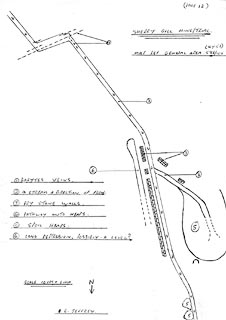 click to enlarge click to enlargeKMR37.jpg "SHERRY GILL MINE/TRIAL." item:- private collection : 82 Image © see bottom of page |
|
|
|
||
| :- |
South west of Wet Sleddale Reservoir. |
|
| Adams, John: 1988: Mines of the Lake District Fells: Dalesman Books (Lancaster, Lancashire)::
ISBN 0 85206 931 6 |
||
|
|
||
 Lakes Guides menu.