 Old Cumbria Gazetteer
 |
 |
|
| Smaithwaite Bridge, St John's Castlerigg etc | ||
| Smaithwaite Bridge | ||
| site name:- | St John's Beck | |
| civil parish:- | St John's Castlerigg and Wythburn (formerly Cumberland) | |
| county:- | Cumbria | |
| locality type:- | bridge | |
| coordinates:- | NY31551955 | |
| 1Km square:- | NY3119 | |
| 10Km square:- | NY31 | |
|
|
||
| evidence:- | old map:- OS County Series (Cmd 64 16) placename:- Smaithwaite Bridge |
|
| source data:- | Maps, County Series maps of Great Britain, scales 6 and 25
inches to 1 mile, published by the Ordnance Survey, Southampton,
Hampshire, from about 1863 to 1948. |
|
|
|
||
| evidence:- | old map:- Saxton 1579 |
|
| source data:- | Map, hand coloured engraving, Westmorlandiae et Cumberlandiae Comitatus ie Westmorland
and Cumberland, scale about 5 miles to 1 inch, by Christopher Saxton, London, engraved
by Augustinus Ryther, 1576, published 1579-1645.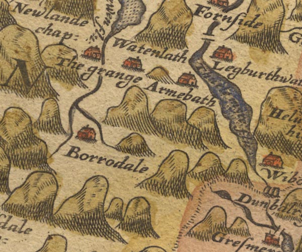 Sax9NY21.jpg North of Legberthaite. item:- private collection : 2 Image © see bottom of page |
|
|
|
||
| evidence:- | probably old map:- Mercator 1595 (edn?) placename:- |
|
| source data:- | Map, hand coloured engraving, Northumbria, Cumberlandia, et
Dunelmensis Episcopatus, ie Northumberland, Cumberland and
Durham etc, scale about 6.5 miles to 1 inch, by Gerard Mercator,
Duisberg, Germany, about 1595.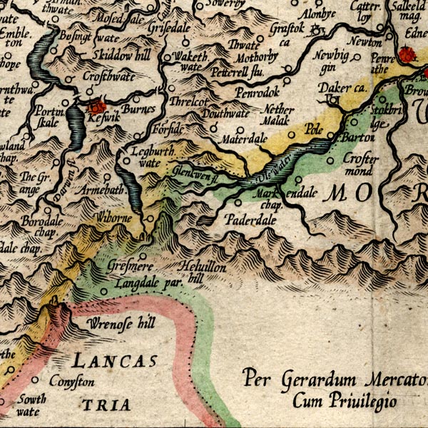 MER8CumF.jpg "" double across a stream; bridge, over St John's Beck item:- JandMN : 169 Image © see bottom of page |
|
|
|
||
| evidence:- | old map:- Speed 1611 (Cmd) |
|
| source data:- | Map, hand coloured engraving, Cumberland and the Ancient Citie
Carlile Described, scale about 4 miles to 1 inch, by John Speed,
1610, published by J Sudbury and George Humble, Popes Head
Alley, London, 1611-12.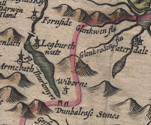 SP11NY31.jpg double line across St John's Beck item:- private collection : 16 Image © see bottom of page |
|
|
|
||
| evidence:- | old map:- Jansson 1646 |
|
| source data:- | Map, hand coloured engraving, Cumbria and Westmoria, ie
Cumberland and Westmorland, scale about 3.5 miles to 1 inch, by
John Jansson, Amsterdam, Netherlands, 1646.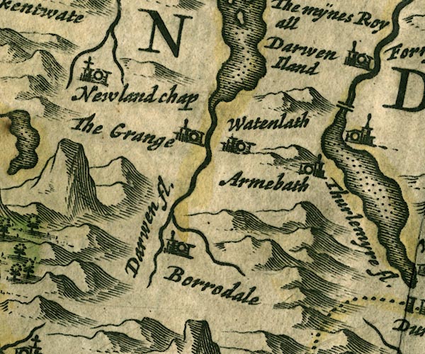 JAN3NY21.jpg Double line crossing the stream; this rather than High Bridge. item:- JandMN : 88 Image © see bottom of page |
|
|
|
||
| evidence:- | old map:- Ogilby 1675 (plate 96) placename:- Smathods Bridge |
|
| source data:- | Road strip map, hand coloured engraving, the Road from Kendal to
Cockermouth, and the Road from Egremond to Carlisle, scale about
1 inch to 1 mile, by John Ogilby, London, 1675.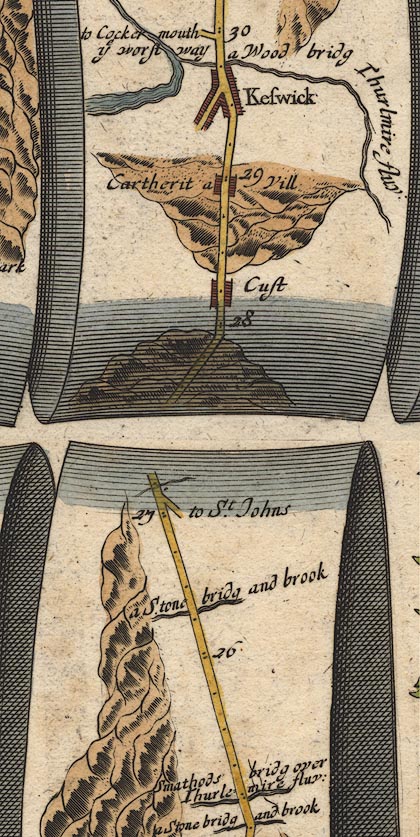 OG96m025.jpg In mile 25, Cumberland. "Smathods bridg over Thurlemire fluv:" the road crossing the river, no bridge drawn. item:- JandMN : 22 Image © see bottom of page |
|
|
|
||
| evidence:- | possibly old map:- Sanson 1679 |
|
| source data:- | Map, hand coloured engraving, Ancien Royaume de Northumberland
aujourdhuy Provinces de Nort, ie the Ancient Kingdom of
Northumberland or the Northern Provinces, scale about 9.5 miles
to 1 inch, by Nicholas Sanson, Paris, France, 1679. click to enlarge click to enlargeSAN2Cm.jpg double line over a stream; bridge item:- Dove Cottage : 2007.38.15 Image © see bottom of page |
|
|
|
||
| evidence:- | old map:- Seller 1694 (Cmd) |
|
| source data:- | Map, uncoloured engraving, Cumberland, scale about 12 miles to 1
inch, by John Seller, 1694. click to enlarge click to enlargeSEL9.jpg two lines cross a stream; bridge item:- Dove Cottage : 2007.38.89 Image © see bottom of page |
|
|
|
||
| evidence:- | old map:- Morden 1695 (Cmd) |
|
| source data:- | Map, uncoloured engraving, Cumberland, scale about 4 miles to 1
inch, by Robert Morden, 1695, published by Abel Swale, the
Unicorn, St Paul's Churchyard, Awnsham, and John Churchill, the
Black Swan, Paternoster Row, London, 1695-1715.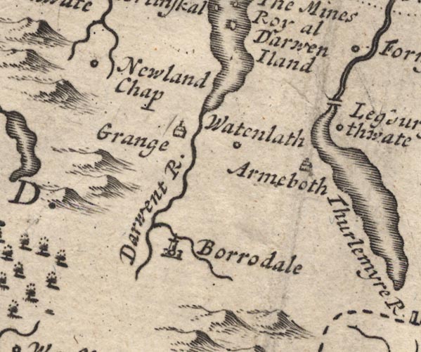 MD12NY21.jpg Double line over a stream, near Legburthwate. item:- JandMN : 90 Image © see bottom of page |
|
|
|
||
| evidence:- | old map:- Bowen 1720 (plate 260) placename:- Smathode Bridge |
|
| source data:- | Road strip map, uncoloured engraving, pl.260, The Road from
Kendal to Cockermouth, scale about 2 miles to 1 inch, with
sections in Westmorland and Cumberland, published by Emanuel
Bowen, St Katherines, London, 1720.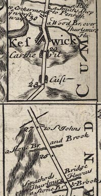 B260m25.jpg "Smathode Bridge over Thurlmire Fluvius" At mile 25. item:- private collection : 1.260 Image © see bottom of page |
|
|
|
||
| evidence:- | old map:- Bowen and Kitchin 1760 |
|
| source data:- | Map, hand coloured engraving, A New Map of the Counties of
Cumberland and Westmoreland Divided into their Respective Wards,
scale about 4 miles to 1 inch, by Emanuel Bowen and Thomas
Kitchin et al, published by T Bowles, Robert Sayer, and John
Bowles, London, 1760.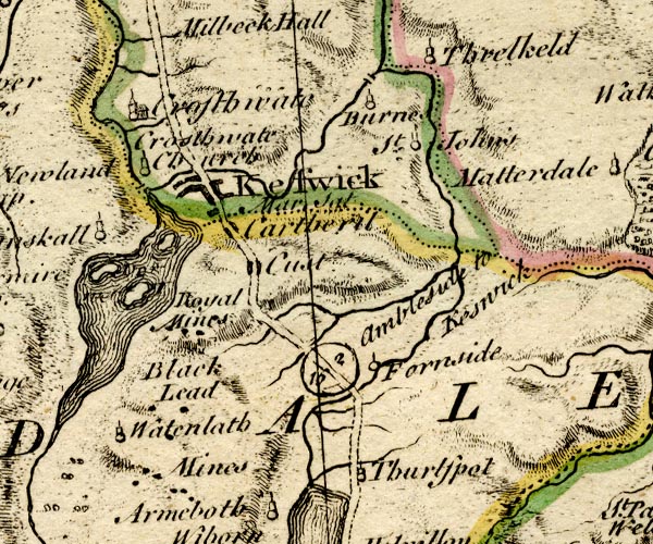 BO18NY21.jpg road across stream item:- Armitt Library : 2008.14.10 Image © see bottom of page |
|
|
|
||
| evidence:- | old map:- Donald 1774 (Cmd) |
|
| source data:- | Map, hand coloured engraving, 3x2 sheets, The County of Cumberland, scale about 1
inch to 1 mile, by Thomas Donald, engraved and published by Joseph Hodskinson, 29
Arundel Street, Strand, London, 1774.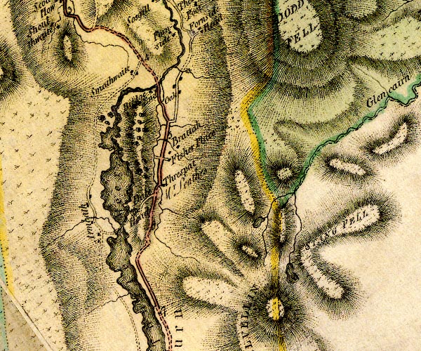 D4NY31NW.jpg double line across a river; a bridge at Bridge End item:- Carlisle Library : Map 2 Image © Carlisle Library |
|
|
|
||
| evidence:- | road book:- Cary 1798 (2nd edn 1802) placename:- Smalthwaite Bridge |
|
| source data:- | Road book, itineraries, Cary's New Itinerary, by John Cary, 181
Strand, London, 2nd edn 1802. goto source goto source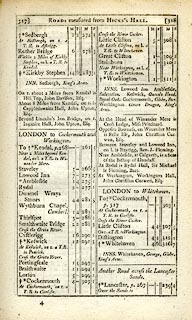 click to enlarge click to enlargeC38317.jpg page 317-318 "Smalthwaite Bridge" item:- JandMN : 228.1 Image © see bottom of page |
|
|
|
||
| evidence:- | old map:- Laurie and Whittle 1806 placename:- Smallthwaite Bridge |
|
| source data:- | Road map, Completion of the Roads to the Lakes, scale about 10
miles to 1 inch, by Nathaniel Coltman? 1806, published by Robert
H Laurie, 53 Fleet Street, London, 1834. click to enlarge click to enlargeLw18.jpg "Smallthwaite Bridge 289" bridge; distance from London item:- private collection : 18.18 Image © see bottom of page |
|
|
|
||
| evidence:- | perhaps old print:- Wilkinson 1810 (plate 18) |
|
| source data:- | Print, uncoloured soft ground etching, View on the Ambleside Road, near Bridgefoot,
with part of St John's Vale, Cumberland, by Joseph Wilkinson, engraved by William
Frederick Wells, published by R Ackermann, Repository of Arts, 101 Strand, London,
1810.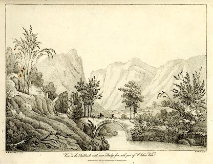 click to enlarge click to enlargeWKN118.jpg Perhaps Smaithwaite Bridge. Plate 18 in Select Views in Cumberland, Westmoreland, and Lancashire. No.22 in this binding. printed at bottom left, right, centre:- "The Revd. Jos: Wilkinson delt. / W. F. Wells sculpt. / View on the Ambleside Road, near Bridge Foot, with part of St John's Vale. / Publish'd June 1. 1810. by R. Ackermann. 101. Strand. London." item:- Fell and Rock Climbing Club : MN4.18 Image © see bottom of page |
|
|
|
||
| evidence:- | descriptive text:- Ford 1839 (3rd edn 1843) placename:- Smalthwaite Bridge |
|
| source data:- | Guide book, A Description of Scenery in the Lake District, by
Rev William Ford, published by Charles Thurnam, Carlisle, by W
Edwards, 12 Ave Maria Lane, Charles Tilt, Fleet Street, William
Smith, 113 Fleet Street, London, by Currie and Bowman,
Newcastle, by Bancks and Co, Manchester, by Oliver and Boyd,
Edinburgh, and by Sinclair, Dumfries, 1839. goto source Page 50:- "... A little beyond, cross St. John's Beck, the water of which flows out of Thirlmere, by Smalthwaite Bridge of one arch, which is a fine study for the artist, along with its accompaniments. ..." goto sourcePage 165:- "..." "... the picturesque bridge of Smalthwaite spans, with a single arch, St. John's Beck, ..." |
|
|
|
||
| evidence:- | old photograph:- Bell 1880s-1940s |
|
| source data:- | Photograph, black and white, Smaithwaite Bridge, Castle Rock, etc, St John's Castlerigg
and Wythburn, Cumberland, by Herbert Bell, photographer, Ambleside, Westmorland, 1890s.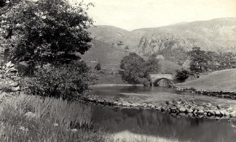 click to enlarge click to enlargeHB0717.jpg internegative at lower left:- "H. Bell" item:- Armitt Library : ALPS381 Image © see bottom of page |
|
|
|
||
| evidence:- | old map:- Bell 1892 placename:- Smaithwaite Bridge |
|
| source data:- | Map, colour lithograph, Road Map of Cumberland, by George Joseph
Bell, scale about 2.5 miles to 1 inch, printed by Charles
Thurnam and Sons, Carlisle, Cumberland, 1892.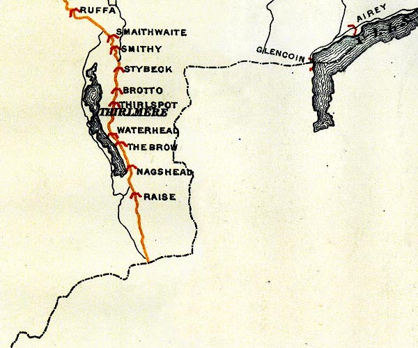 BEL9NY31.jpg "SMAITHWAITE" bridge symbol Road map of Cumberland showing County Bridges item:- Carlisle Library : Map 38 Image © Carlisle Library |
|
|
|
||
Lakes Guides menu.