Old Cumbria Gazetteer
 |
 |
|
||
| Speet Gill | ||||
| runs into:- |  Wiza Beck (?) Wiza Beck (?) |
|||
|
|
||||
| civil parish:- | Westward (formerly Cumberland) | |||
| civil parish:- | Wigton (formerly Cumberland) | |||
| county:- | Cumbria | |||
| locality type:- | river | |||
| 1Km square:- | NY2747 (etc) | |||
| 10Km square:- | NY24 | |||
|
|
||||
| evidence:- | old map:- OS County Series (Cmd 29 6) placename:- Speed Gill |
|||
| source data:- | Maps, County Series maps of Great Britain, scales 6 and 25
inches to 1 mile, published by the Ordnance Survey, Southampton,
Hampshire, from about 1863 to 1948. OS County Series (Cmd 29 10) |
|||
|
|
||||
| evidence:- | old map:- Ogilby 1675 (plate 96) |
|||
| source data:- | Road strip map, hand coloured engraving, the Road from Kendal to
Cockermouth, and the Road from Egremond to Carlisle, scale about
1 inch to 1 mile, by John Ogilby, London, 1675.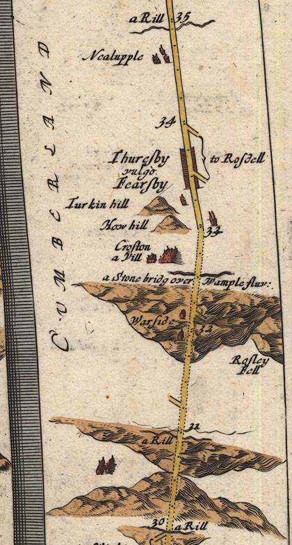 OG96Bm30.jpg In mile 30, Cumberland. "a Rill" drawn across the road. item:- JandMN : 22 Image © see bottom of page |
|||
|
|
||||
| places:- |
|
|||
|
||||
Lakes Guides menu.