 Old Cumbria Gazetteer
 |
 |
|
| included in:- |
 Derwent Water Derwent Water |
|
| viewpoint, Crow Park | ||
| site name:- | Crow Park | |
| locality:- | Keswick | |
| civil parish:- | Keswick (formerly Cumberland) | |
| county:- | Cumbria | |
| locality type:- | viewpoint | |
| coordinates:- | NY26352305 | |
| 1Km square:- | NY2623 | |
| 10Km square:- | NY22 | |
|
|
||
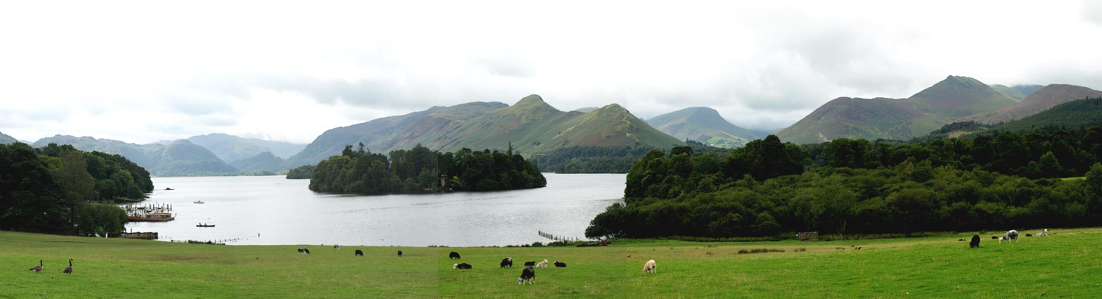 Click to enlarge BPP95.jpg View up Derwent Water from top of the Crow Park drumlin. (taken 24.8.2008) |
||
|
|
||
| evidence:- | descriptive text:- West 1778 (11th edn 1821) placename:- station, Derwent Water, West 2 |
|
| source data:- | Guide book, A Guide to the Lakes, by Thomas West, published by
William Pennington, Kendal, Cumbria once Westmorland, and in
London, 1778 to 1821. goto source Page 88:- "STATION II. The next celebrated station is at a small distance, named Crow-park, which formerly contained a grove of oaks of immemorial growth, ..." "This now shadeless pasture, is a gentle eminence, not too high, on the very margin" goto sourcePage 89:- "of the lake, which it commands in all its extent, and looks full into the craggy pass of Borrowdale. Of this station, Mr. Gray speaks thus,- 'October 4, I walked to Crow-park, now a rough pasture, once a glade of ancient oaks, whose large roots still remain in the ground, but nothing has sprung from them. If one single tree had remained, this would have been an unparalleled spot; and Smith judged right when he took his print of the lake from hence, for it is a gentle eminence, not too high, on the very margin of the water, and commands it from end to end, looking full into the gorge of Borrowdale. I prefer it even to Cockshut-hill, which lies beside it, and to which I walked in the afternoon; it is covered with young trees, both sown and planted, oak, spruce, Scotch fir, &c. all which thrive wonderfully. There is an easy ascent to the top, and the view is far preferable to that on Castle-hill, because this is lower and nearer the lake; for I find all points that are much elevated, spoil the beauty of the valley, and make its parts, which are not large, look poor and diminutive.'" "..." goto sourcePage 104:- "Mr. Gray was much pleased with an evening view under Crow-park. 'In the evening,' says he, 'I walked alone down to the lake, by the side of Crow-park, after sun-set, and saw the solemn colouring of the night draw" goto sourcePage 105:- "on, the last gleam of sunshine fading away on the hill tops, the deep serene of the waters, and the long shadows of the mountains thrown across them, till they nearly touched the hithermost shore. At a distance were heard the murmurs of many water-falls not audible in day time; I wished for the moon, but she was dark to me and silent," "'Hid in her vacant interlunar cave.'" goto sourceAddendum; Mr Gray's Journal, 1769 Page 206:- "..." "Oct. 4. I walked to Crow-park, now a rough pasture, once a glade of ancient oaks, whose large roots still remain in the ground, but nothing has sprung from them. If one single tree had remained, this would have been an unparalleled spot: and Smith judged right when he took his print of the lake from hence, for it is a gentle eminence, not too high, on the very margin of the water, and commanding it from end to end, looking full into the gorge of Borrowdale. ..." |
|
|
|
||
| evidence:- | old map:- Crosthwaite 1783-94 (Der) placename:- station, Derwent Water, West 1 |
|
| source data:- | Map, uncoloured engraving, An Accurate Map of the Matchless Lake
of Derwent, ie Derwent Water, scale about 3 inches to 1 mile, by
Peter Crosthwaite, Keswick, Cumberland, 1783, version published
1800.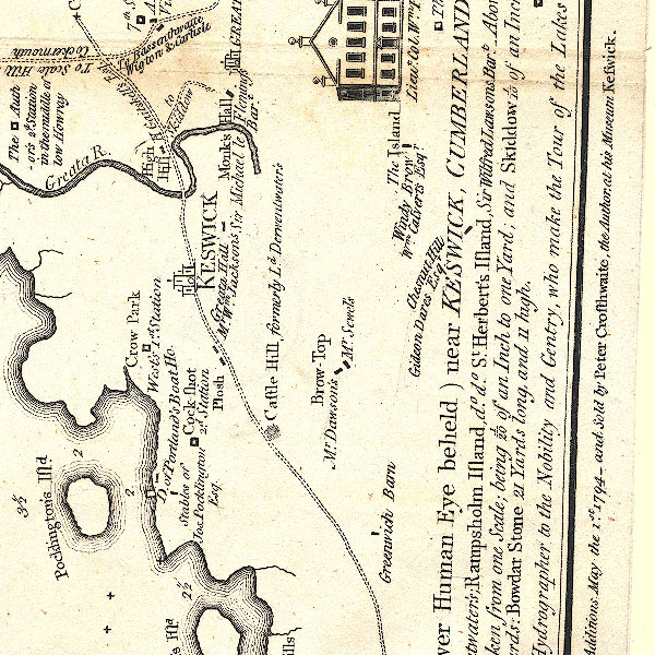 CT2NY22Q.jpg "Crow Park / West's 1st. Station" item:- Armitt Library : 1959.191.3 Image © see bottom of page |
|
|
|
||
| evidence:- | old text:- Clarke 1787 item:- landscape |
|
| source data:- | Guide book, A Survey of the Lakes of Cumberland, Westmorland,
and Lancashire, written and published by James Clarke, Penrith,
Cumberland, and in London etc, 1787; published 1787-93. goto source Page 64:- "... It [Crow Park] will soon be laid down to grass, and will then afford an excellent station for the landscape-painter: Mr Hannan, (who was the first that I remember as coming for the purpose of drawing,) admired this view the most of any in the country. Mr Smith, Mr Grey, and every other painter likewise highly approved it, and at present it is much more beautiful than it was at that time, owing to the many improvements made on the islands and environs of the Lake." |
|
|
|
||
| evidence:- | outline view:- Otley 1823 (4th edn 1830) |
|
| source data:- | Print, engraving, outline view, Mountains South West of Derwentwater as seen from
Keswick, published by Jonathan Otley, Keswick, Cumberland et al, 1830.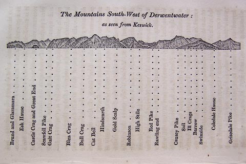 click to enlarge click to enlargeO75E06.jpg p.115 in A Concise Description of the English Lakes, by Jonathan Otley, 4th edition, 1830. printed at top:- "The Mountains South-West of Derwentwater: / as seen from Keswick." printed at bottom:- "Brund and Glaramara / Esk Hause / Castle Crag and Great End / Scawfell Pike / Gait Crag / Blea Crag / Bull Crag / Cat Bell / Hindscarth / Gold Scalp / Robinson / High Stile / Red Pike / Rawling end / Causey Pike / Sail / Ill Crags / Barrow / Swinside / Coledale Hause / Grisedale Pike" item:- Armitt Library : A1175.6 Image © see bottom of page |
|
|
|
||
| evidence:- | outline view:- Otley 1823 (5th edn 1834) |
|
| source data:- | Print, woodcut outline view, The Mountains South West of Derwentwater, by Jonathan
Otley, Keswick, Cumberland now Cumbria, 1834.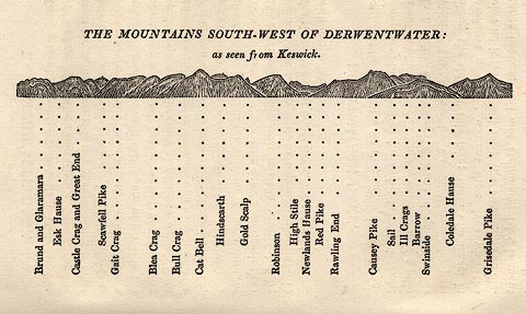 click to enlarge click to enlargeOT2E04.jpg Printed on p.21 of A Concise Description of the English Lakes, by Jonathan Otley, 5th edition, 1834. printed at top:- "THE MOUNTAINS SOUTH-WEST OF DERWENTWATER: / as seen from Keswick." printed at bottom:- "Brund and Glaramara / Esk Hause / Castle Crag and Great End / Scawfell Pike / Gait Crag / Blea Crag / Bull Crag / Cat Bell / Hindscarth / Gold Scalp / Robinson / High Stile / Newlands Hause / Red Pike / Rawling End / Causey Pike / Sail / Ill Crags / Barrow / Swinside / Coledale Hause / Grisedale Pike" item:- JandMN : 48.5 Image © see bottom of page |
|
|
|
||
| evidence:- | outline view:- Otley 1823 (8th edn 1849) |
|
| source data:- | Print, engraving, outline view of mountains, Derwent Water from Crow Park, drawn by
Mr Binns, Halifax, engraved by Mr Jewitt, Headington, Oxfordshire, published by Jonathan
Otley, Keswick, Cumberland et al, 1849.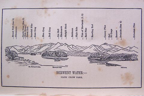 click to enlarge click to enlargeO80E06.jpg Opposite p.10 of A Descriptive Guide of the English Lakes, by Jonathan Otley, 8th edition, 1849. printed at bottom:- "DERWENT WATER: - / FROM CROW PARK." printed at top:- "Brund Fell (line 2) / Glaramara / Castle Crag (line 3) / (Esk Hause) / Great End / Scawfell Pike / Gate Crag / Blea Crag / Bull Crag / Cat Bell / Hindscarth / Skelgill Bank / Robinson / High Stile / Vale of Newlands (l.3) / Red Pike / Rawling End / Causey Pike / Sail / Ill Crags / Barrow / Swinside (line 2) / Grisedale Pike" printed at bottom:- "St. Herbert's Isle. Derwent Isle. Isthmus." Looking SW; 90 degree view, S to W. item:- Armitt Library : A1180.7 Image © see bottom of page |
|
|
|
||
| evidence:- | descriptive text:- Ford 1839 (3rd edn 1843) placename:- Crow Park |
|
| source data:- | Guide book, A Description of Scenery in the Lake District, by
Rev William Ford, published by Charles Thurnam, Carlisle, by W
Edwards, 12 Ave Maria Lane, Charles Tilt, Fleet Street, William
Smith, 113 Fleet Street, London, by Currie and Bowman,
Newcastle, by Bancks and Co, Manchester, by Oliver and Boyd,
Edinburgh, and by Sinclair, Dumfries, 1839. goto source Page 57:- "..." "CROW PARK," "Lying between the town and lake, and once covered with oaks, though now denuded of its leafy honours, is a gentle eminence presenting several beautiful views, which shall be pointed out by way of enumeration. The first view is towards the head of the lake, beyond which the Borrowdale mountains are observed clustering together above Castle Crag, the conical hill in the centre of the opening. Second, directly west over the lake, between Vicar's" goto sourcePage 59:- "Island and the isthmus, are the Newlands mountains, and beyond them, Robinson and High Stile on the east and west sides of Buttermere respectively. Third, over the lower end of the lake is a scene of beauty and grandeur; villas and the village of Braithwaite, partially hidden by trees, are scattered over gentle eminences, Grizedale Pike towering over the whole. And fourth, a very narrow strip of Bassenthwaite may be observed over the meadows, and the easy swelling hills which in the remote distance grace the foot of the lake." |
|
|
|
||
| indexing | ||
| person:- | author : West, Thomas |
|
| place:- | Derwent Water | |
| date:- | 1778 |
|
| period:- | 18th century, late | |
| period:- | 1780s | |
| item:- | guide book; Guide to the Lakes |
|
|
|
||
Lakes Guides menu.