 Old Cumbria Gazetteer
 |
 |
|
| included in:- |
 Ullswater Ullswater |
|
| viewpoint, Stybarrow Crag | ||
| site name:- | Stybarrow Crag | |
| civil parish:- | Patterdale (formerly Westmorland) | |
| county:- | Cumbria | |
| locality type:- | viewpoint | |
| 1Km square:- | NY3817 | |
| 10Km square:- | NY31 | |
|
|
||
| evidence:- | descriptive text:- West 1778 (11th edn 1821) |
|
| source data:- | Guide book, A Guide to the Lakes, by Thomas West, published by
William Pennington, Kendal, Cumbria once Westmorland, and in
London, 1778 to 1821. goto source Page 156:- "[Pass] Newbridge, and the road winds up a steep rock, having the lake underneath you on the left. From the top, you have a view under the trees, both up and down the lake. Martindale-fell, a naked grey rock, on the opposite shore, rises abruptly from the water, to an Alpine height, and with an astonishing effect. The rock you stand on hangs over the lake, which seems blue and unfathomable to the eye. An island in the middle space has a beautiful appearance. This is the most romantic, striking, and terrible situation upon the lake, especially if the wind blows the surges of water against the rock below you. The shores on both sides upwards are very pleasing, and the little decorating isles are scattered in the most exquisite taste, and delightful order. ..." |
|
|
|
||
| evidence:- | old map:- Crosthwaite 1783-94 (Ull) placename:- Sty Barrow Crag placename:- station, Ullswater, West 2 |
|
| source data:- | Map, uncoloured engraving, Accurate Map of the Beautiful Lake of
Ullswater, scale about 3 inches to 1 mile, by Peter Crosthwaite,
Keswick, Cumberland, 1783, version published 1800.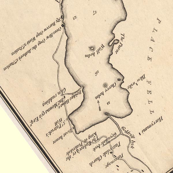 CT5NY31Y.jpg "Sty Barrow Crag / West's 2d. Station" item:- Armitt Library : 1959.191.7 Image © see bottom of page |
|
|
|
||
| indexing | ||
| person:- | author : West, Thomas |
|
| place:- | Ullswater | |
| date:- | 1778 |
|
| period:- | 18th century, late | |
| period:- | 1780s | |
| item:- | guide book; Guide to the Lakes |
|
|
|
||
Lakes Guides menu.