 Old Cumbria Gazetteer
 |
 |
|
| included in:- |
 Derwent Water Derwent Water |
|
| viewpoint, Swinside | ||
| site name:- | Swinside | |
| civil parish:- | Above Derwent (formerly Cumberland) | |
| county:- | Cumbria | |
| locality type:- | viewpoint | |
| 1Km square:- | NY2422 | |
| 10Km square:- | NY22 | |
| altitude:- | 801 feet | |
| altitude:- | 244m | |
|
|
||
| evidence:- | descriptive text:- West 1778 (11th edn 1821) placename:- station, Derwent Water, West 5 |
|
| source data:- | Guide book, A Guide to the Lakes, by Thomas West, published by
William Pennington, Kendal, Cumbria once Westmorland, and in
London, 1778 to 1821. goto source Page 105:- "STATION V. This view [that from Crow Park] is seen to much greater advantage from the side of Swinside, a little before sun-set, where the vale and both the lakes are in full view, with the whole extent of rocky shore at the upper, and the flextures of the lower lake. And when the last beams of the sun rest on the purple summit of Skiddaw, and the deep shade of Wythop's wooded brows is stretched over the lake, the effect is amazingly great." |
|
|
|
||
| evidence:- | old map:- Crosthwaite 1783-94 (Der) placename:- station, Derwent Water, West 5 |
|
| source data:- | Map, uncoloured engraving, An Accurate Map of the Matchless Lake
of Derwent, ie Derwent Water, scale about 3 inches to 1 mile, by
Peter Crosthwaite, Keswick, Cumberland, 1783, version published
1800.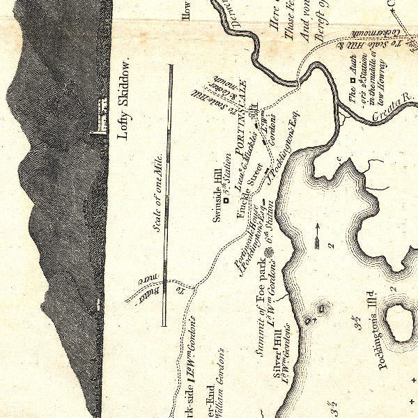 CT2NY22K.jpg "Swinside Hill / 5th. Station" item:- Armitt Library : 1959.191.3 Image © see bottom of page |
|
|
|
||
| indexing | ||
| person:- | author : West, Thomas |
|
| place:- | Derwent Water | |
| date:- | 1778 |
|
| period:- | 18th century, late | |
| period:- | 1780s | |
| item:- | guide book; Guide to the Lakes |
|
|
|
||
Lakes Guides menu.