 Old Cumbria Gazetteer
 |
 |
|
| included in:- |
 Derwent Water Derwent Water |
|
| viewpoint, Walla Crag | ||
| site name:- | Walla Crag (end of) | |
| civil parish:- | Borrowdale (formerly Cumberland) | |
| county:- | Cumbria | |
| locality type:- | viewpoint | |
| 1Km square:- | NY2720 | |
| 10Km square:- | NY22 | |
|
|
||
| evidence:- | descriptive text:- West 1778 (11th edn 1821) placename:- station, Derwent Water, West 3 |
|
| source data:- | Guide book, A Guide to the Lakes, by Thomas West, published by
William Pennington, Kendal, Cumbria once Westmorland, and in
London, 1778 to 1821. goto source Page 89:- "STATION III. A third station on this side, will be found by keeping along the line of shore, till Stable-hills be on the right, and Wallow-crag directly over you on the left; then, without the gate, on the edge of the" goto sourcePage 90:- "common, observe two huge fragments of ferruginous coloured rock, pitched into the side of the mountain by their descent. Here all that is great or pleasing on the lake, all that is grand or sublime in the environs, lie before you in a beautiful order, and natural disposition. Looking down upon the water, the four large islands appear distinctly over the peninsula of Stable-hills. Lords-island, richly dressed in wood. A little to the left, Vicar's-isle rises in beautiful and circular form; Rampsholme is catched in a line between that and St. Herbert's-island, which traverses the lake in an oblique direction, and has a fine effect. These are the four most considerable islands on the lake. Under Foe-park, a round hill completely clothed in wood, two small islets interrupt the line of" goto sourcePage 91:- "shore, and charm the eye in the passage from Vicar's-isle to Ramps-holme. Another islet, above St. Herberts-island, has a similar effect. All idea of river or outlet is here excluded; but, over a neck of undulated land, finely scattered with trees, distant water is just seen, behind Lord's-island. The white church of Crosthwaite is here visible, under Skiddaw, which forms the strongest back-ground. The opposite shore is bounded by a range of hills, down to the entrance of Newland vale, where Cawsey-pike, and Thornthwaite rise in Alpine pride, out-done only by their supreme lord, Skiddaw. Their skirts descend in gentle slopes, and ends (sic) in cultivated grounds. The whole of the western coast is beautiful beyond what words can express, and the north end exhibits what is most gentle and pleasing in landscape. The southern extremity of the lake is a violent contrast to all this. Falcon-crag, an immense rock, hangs over your head, and upwards,a forest of broken pointed rocks, in a semicircular sweep, towering in-" goto sourcePage 92:- "[in]ward, form the most horrid amphitheatre that ever eye beheld in the wild forms of convulsed nature. The immediate margin of the lake is, however, a sweet variegated shore of meadow and pasture, up to the foot of the rocks. Over a border of hedge-row trees, Lowdore-house is seen, under Hallow-stone-crag, a sloping rock, whose back is covered with soft vegetation. Beyond it, appear the awful craggy rocks, that conceal the pass into Borrowdale, and at their feet a stripe of verdant meadow, through which the Derwent serpentizes to the lake in silence. ..." |
|
|
|
||
| evidence:- | old map:- Crosthwaite 1783-94 (Der) placename:- station, Derwent Water, West 3 |
|
| source data:- | Map, uncoloured engraving, An Accurate Map of the Matchless Lake
of Derwent, ie Derwent Water, scale about 3 inches to 1 mile, by
Peter Crosthwaite, Keswick, Cumberland, 1783, version published
1800.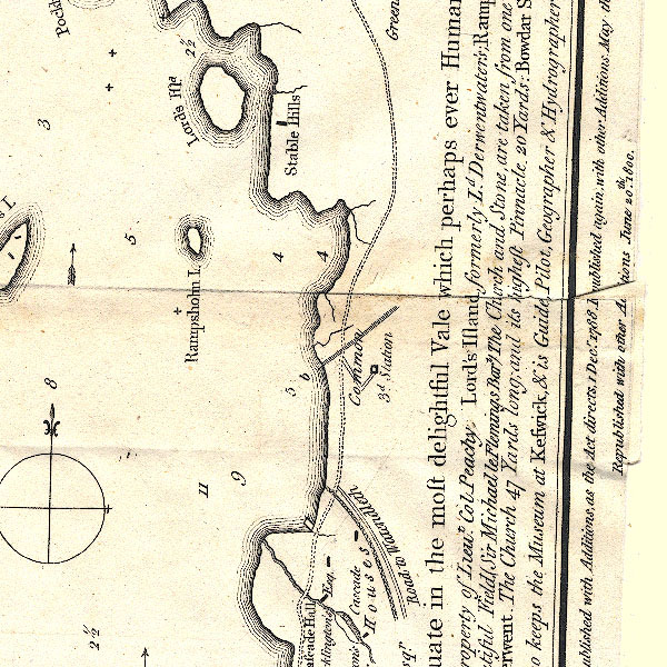 CT2NY21U.jpg "Common / 3d. Station" item:- Armitt Library : 1959.191.3 Image © see bottom of page |
|
|
|
||
| evidence:- | old text:- Clarke 1787 placename:- Wallow Cragg placename:- Falcon Cragg |
|
| source data:- | Guide book, A Survey of the Lakes of Cumberland, Westmorland,
and Lancashire, written and published by James Clarke, Penrith,
Cumberland, and in London etc, 1787; published 1787-93. goto source Page 71:- "..." "Mr West speaks much of a station near this place for the artist: I shall give his own words, for I do not admire it myself; it takes in too much, nor are the objects so distinct as he speaks: besides, Skiddow, which is the back ground, is so far distant as to make it lose much of its grandeur." ""A third station on this side, will be found, by keeping along the line of the shore, till Stable-Hills be on the right, and Wallow-Cragg directly over you on the left: ..." See Thomas West's description, Guide to the Lakes, 11th edn 1821, pp.89-91. "This station of his I never could find; for unless you go to the top of Falcon-Cragg, Lord's Isle is lost between Stable-Hills and Friar-Cragg, and doth not appear to be an island: nor is Vicar's Island seen, unless you take up your station under Wallow-Cragg; then you do not see the white church of Keswick, as he calls it. He must, therefore, I imagine, have been upon the top of Falcon-Cragg, or have wrote the description at the inn, and forgot their situations. Take a rule and lay it upon the plan No.VI. from these stations to the several objects, and the reader will be convinced of what I say." |
|
|
|
||
| indexing | ||
| person:- | author : West, Thomas |
|
| place:- | Derwent Water | |
| date:- | 1778 |
|
| period:- | 18th century, late | |
| period:- | 1780s | |
| item:- | guide book; Guide to the Lakes |
|
|
|
||
Lakes Guides menu.