 Old Cumbria Gazetteer
 |
 |
|
| Swinside hill, Above Derwent | ||
| Swinside | ||
| civil parish:- | Above Derwent (formerly Cumberland) | |
| county:- | Cumbria | |
| locality type:- | hill | |
| coordinates:- | NY24322244 | |
| 1Km square:- | NY2422 | |
| 10Km square:- | NY22 | |
| altitude:- | 803 feet | |
| altitude:- | 245m | |
|
|
||
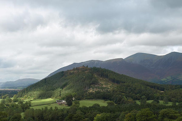 BRP44.jpg (taken 25.9.2009) 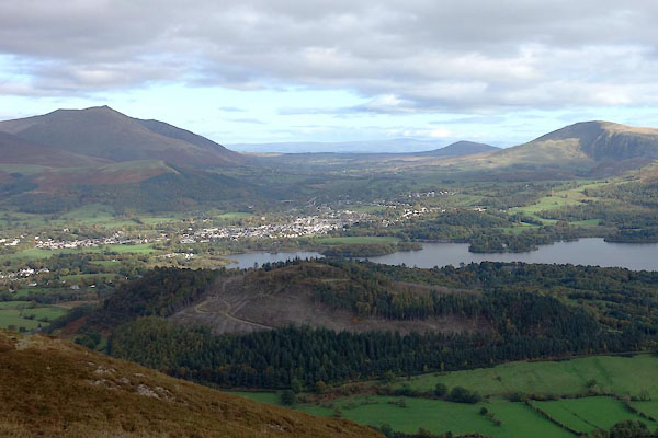 BZO08.jpg Scarred by clear falling. (taken 24.10.2013) |
||
|
|
||
| evidence:- | old map:- OS County Series (Cmd 64 5) placename:- Swinside |
|
| source data:- | Maps, County Series maps of Great Britain, scales 6 and 25
inches to 1 mile, published by the Ordnance Survey, Southampton,
Hampshire, from about 1863 to 1948. |
|
|
|
||
| evidence:- | old map:- Crosthwaite 1783-94 (Der) placename:- Swinside Hill |
|
| source data:- | Map, uncoloured engraving, An Accurate Map of the Matchless Lake
of Derwent, ie Derwent Water, scale about 3 inches to 1 mile, by
Peter Crosthwaite, Keswick, Cumberland, 1783, version published
1800.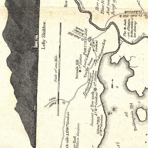 CT2NY22K.jpg "Swinside Hill / 5th. Station" item:- Armitt Library : 1959.191.3 Image © see bottom of page |
|
|
|
||
| evidence:- | outline view:- Otley 1823 (4th edn 1830) placename:- Swinside |
|
| source data:- | Print, engraving, outline view, Mountains South West of Derwentwater as seen from
Keswick, published by Jonathan Otley, Keswick, Cumberland et al, 1830.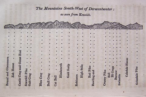 click to enlarge click to enlargeO75E06.jpg p.115 in A Concise Description of the English Lakes, by Jonathan Otley, 4th edition, 1830. "The Mountains South-West of Derwentwater: / as seen from Keswick." "Brund and Glaramara / Esk Hause / Castle Crag and Great End / Scawfell Pike / Gait Crag / Blea Crag / Bull Crag / Cat Bell / Hindscarth / Gold Scalp / Robinson / High Stile / Red Pike / Rawling end / Causey Pike / Sail / Ill Crags / Barrow / Swinside / Coledale Hause / Grisedale Pike" item:- Armitt Library : A1175.6 Image © see bottom of page |
|
|
|
||
| evidence:- | outline view:- Otley 1823 (8th edn 1849) placename:- Swinside |
|
| source data:- | Engraving, outline view of mountains, Derwent Water from Crow Park, drawn by T Binns,
engraved by O Jewitt, opposite p.10 of A Descriptive Guide of the English Lakes, by
Jonathan Otley, 8th edition, 1849.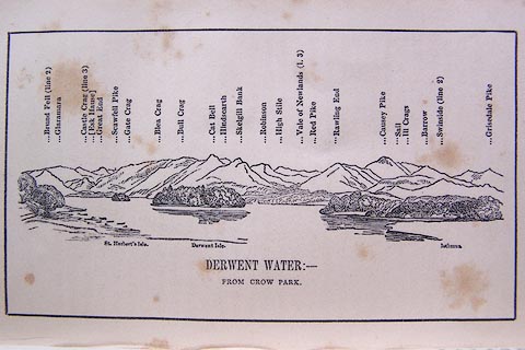 click to enlarge click to enlargeO80E06.jpg item:- Armitt Library : A1180.7 Image © see bottom of page |
|
|
|
||
| evidence:- | outline view:- Otley 1823 (5th edn 1834) |
|
| source data:- | Print, woodcut outline view, The Mountains South West of
Derwentwater, by Jonathan Otley, Keswick, Cumberland, 1830.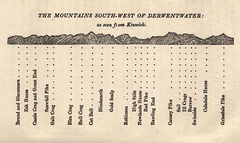 click to enlarge click to enlargeOT2E04.jpg Printed on p.21 of A Concise Description of the English Lakes, by Jonathan Otley, 5th edition, 1834. "THE MOUNTAINS SOUTH-WEST OF DERWENTWATER: as seen from Keswick" "Brund and Glaramara / Esk Hause / Castle Crag and Great End / Scawfell Pike / Gait Crag / Blea Crag / Bull Crag / Cat Bell / Hindscarth / Gold Scalp / Robinson / High Stile / Newlands Hause / Red Pike / Rawling End / Causey Pike / Sail / Ill Crags / Barrow / Swinside / Coledale Hause / Grisedale Pike" item:- JandMN : 48.5 Image © see bottom of page |
|
|
|
||
| evidence:- | old map:- Garnett 1850s-60s H placename:- Swinside |
|
| source data:- | Map of the English Lakes, in Cumberland, Westmorland and
Lancashire, scale about 3.5 miles to 1 inch, published by John
Garnett, Windermere, Westmorland, 1850s-60s.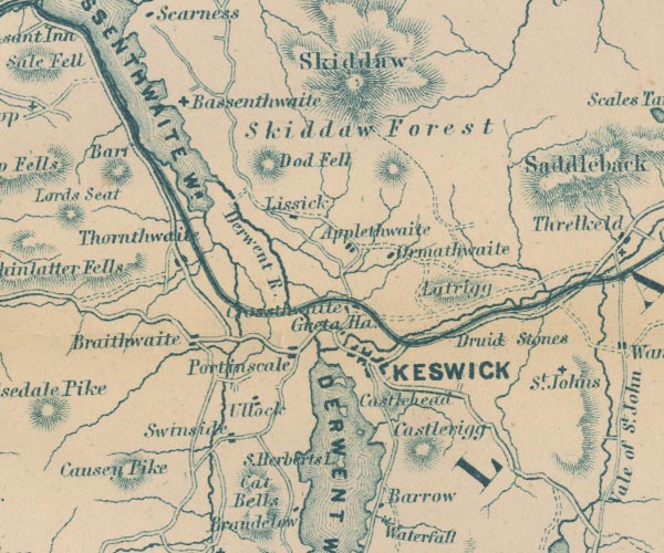 GAR2NY22.jpg "Swinside" blocks, settlement item:- JandMN : 82.1 Image © see bottom of page |
|
|
|
||
| evidence:- | outline view:- Barrow 1888 placename:- Swinside |
|
| source data:- | Outline view, engraving? Outline of Mountain Tops as seen from the Keswick Hotel,
sketched by John Barrow, published by Sampson Low, Marston, Searle, and Rivington,
St Dunstan's House, Fetter Lane, Fleet Street, London, 1888.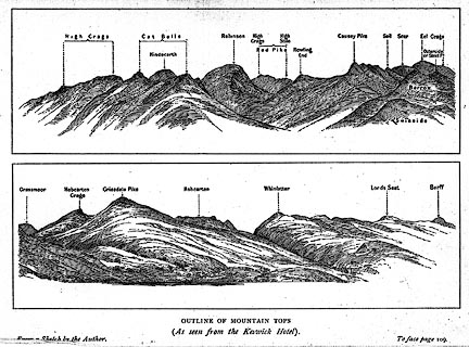 click to enlarge click to enlargeBRW1.jpg "... Swinside ..." item:- Kendal Library : 10.3 Image © see bottom of page |
|
|
|
||
| evidence:- | outline view:- Jenkinson 1875 placename:- Swinside |
|
| source data:- | Print, lithograph, outline view, Panoramic Sketches from Skiddaw, Cumberland, by Edwin
A Pettitt, London, published by Edward Stanford, 55 Charing Cross, London, 1875.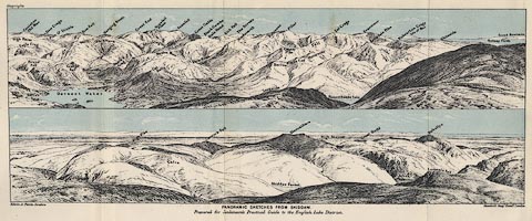 click to enlarge click to enlargeJk01E2.jpg "... Swinside ..." item:- JandMN : 28.8 Image © see bottom of page |
|
|
|
||
| evidence:- | outline view:- Black 1856 (23rd edn 1900) placename:- Swineside |
|
| source data:- | Print, lithograph, Outline Views, Skiddaw and Derwent Water - Mountains as seen at
Lodore Hotel, and Mountains as seen at the Third Gate on Ascending Latrigg on the
Way to Skiddaw, by J Flintoft, Keswick, Cumberland, engraved by R Mason, Edinburgh,
Lothian, about 1900.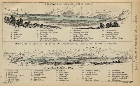 click to enlarge click to enlargeBC08E4.jpg "... 3 Swineside ... 19 Swineside ..." item:- JandMN : 37.14 Image © see bottom of page |
|
|
|
||
| evidence:- | outline view:- Black 1841 (3rd edn 1846) placename:- Swineside |
|
| source data:- | Print, engraving, outline view, Mountains as seen at Lowdore Inn, and Mountains as
seen at the Third Gate on Ascending Latrigg on the Way to Skiddaw, by J Flintoft,
Keswick, Cumberland, engraved by R Mason, Edinburgh, Lothian, about 1846.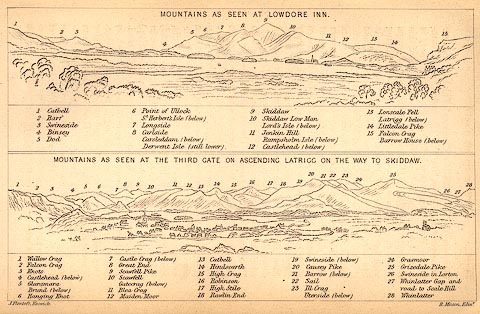 click to enlarge click to enlargeBC02E4.jpg "... 3 Swineside ... 19 Swineside ..." item:- JandMN : 32.7 Image © see bottom of page |
|
|
|
||
| evidence:- | outline view:- Tattersall 1836 placename:- Swinside |
|
| source data:- | Print, engraving, View from Skiddaw, looking South, Cumberland, Westmorland and Lancashire,
drawn by George Tattersall, engraved by W F Topham, published by Sherwood and Co,
Paternoster Row, London, about 1836.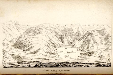 click to enlarge click to enlargeTAT137.jpg The print is captioned with mountain names and acts as an outline view. Tipped in opposite p.91 of The Lakes of England, by George Tattersall. printed at bottom:- "VIEW FROM SKIDDAW, / looking South. / [London Pubd. ...]" printed at p.91:- "... FOUR VIEWS FROM THE SUMMIT OF SKIDDAW. III. LOOKING SOUTH. / ... / 39. Swinside, Cumberland. / ..." item:- Armitt Library : A1204.38 Image © see bottom of page |
|
|
|
||
| evidence:- | old print:- |
|
| source data:- | Print, uncoloured engraving, Derwentwater and Bassenthwaite Lakes from the Road to
Watendlath, Cumberland, published by Sherwood and Co, London, 1836?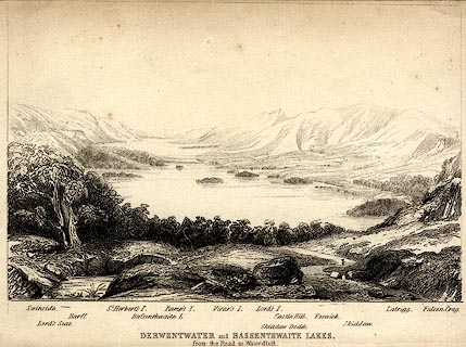 click to enlarge click to enlargePR0370.jpg The view is from just above Ashness Bridge. Objects in the view are identified by a caption at the bottom (unfortunately the print is pale, so some objects are unclear, and the caption seems to be a little misaligned) - Swinside, Lord's Seat, Barff, St. Herbert's I., Bassenthwaite L., Ramp's I., Vicar's I., Lord's I., Skiddaw Dodd, Castle Hill, Keswick, Skiddaw, Latrigg, Falcon Crag. printed at bottom:- "DERWENTWATER and BASSENTHWAITE LAKES. / from the Road to Watendlath." item:- Dove Cottage : 2008.107.370 Image © see bottom of page |
|
|
|
||
 Lakes Guides menu.