 Old Cumbria Gazetteer
 |
 |
|
| Threlkeld Mine, Threlkeld | ||
| Threlkeld Mine | ||
| civil parish:- | Threlkeld (formerly Cumberland) | |
| county:- | Cumbria | |
| locality type:- | lead mine | |
| locality type:- | zinc mine | |
| locality type:- | mine | |
| coordinates:- | NY325261 | |
| 1Km square:- | NY3226 | |
| 10Km square:- | NY32 | |
| references:- | Adams, John: 1988: Mines of the Lake District Fells: Dalesman Books (Lancaster, Lancashire)::
ISBN 0 85206 931 6 |
|
|
|
||
| evidence:- | old text:- Postlethwaite 1877 (3rd edn 1913) placename:- Threlkeld Mine placename:- Gategill Mine placename:- Woodend Mine item:- copper ore; malachite; galena; cerussite; blende; iron pyrites; barytes; Woodend Vein; Gategill Vein; Gategill High Level; Woodend High Level |
|
| source data:- | Book, Mines and Mining in the English Lake District, by John Postlethwaite, Keswick,
published by W H Moss and Sons, Whitehaven, Cumberland now Cumbria, 1877; published
1877-1913. goto source goto sourcepage 96:- "THRELKELD MINE." "On the sides and at the base of Blencathra or Saddleback, as it is commonly called, there is a group of mines, comprising Woodend, Gategill, Bleasegill, Glenderaterra, and Saddleback Old Mine. The ores which they produce are copper pyrites, malachite, galena, cerussite, blende, iron pyrites, and sulphate barytes." "The principal veins are large and well mineralised, and their bearing is north and south." "Gategill is an old mine, having been wrought before the use of gunpowder was known; but the other will scarcely date farther back than the latter part of the eighteenth century. Since that time, however, a considerable extent of ground has been excavated, and a good deal of ore raised, chiefly galena, and some blende." "Woodend Mine is also an old mine, although younger than Gategill, but it has been the most productive of the group. It was re-opened by Messrs. Walton and Cowper, about 60 or 70 years" goto sourcepage 98:- "ago, and they continued working until 1863. After remaining closed thirteen years it was re-opened, together with Gategill Mine, by Mr. W. Porter of Threlkeld, and a Company was formed, called the "Saddleback Mining Co." Some galena was raised, chiefly from Gategill, but at the expiration of three years the proprietors became dispirited, and were disposed to abandon the undertaking, but at this juncture Mr. W. Bawden became a co-partner in the firm, which was renamed the "Threlkeld Mining Co." and his services were secured as Manager. Operations were then conducted in an energetic manner, the mine was properly developed, and large quantities of ore were raised." "The bearing of Woodend vein is about 10 degrees east of north, and of Gategill vein 25 degrees west of north; they form a junction in the northern part of the mine, and Gategill vein being the older, is displaced about 20 fathoms, and this is the most productive portion of the mine." "Contrary to the general rule, the hade of both veins is towards the west." "An important feature connected with the Woodend and Gategill veins is a dyke, or it may perhaps be more correctly described as a laccolite mass of igneous rock. It hades to the north at the rate of five feet per fathom, and in cutting through it in Woodend high level it measured forty fathoms in width, while in the horse level, twenty-three fathoms below, it is divided, ten fathoms of Skiddaw Slate separating the two portions, the united width of the two being a little less than that in the level above. The two masses have decreased a little more in width in the 20-fathom and the 30-fathom levels." "The veins are everywhere highly productive when in contact with the igneous rock." "Woodend vein yields galena, blende, and iron pyrites, in considerable quantities, and is very rich at the junction of the two veins. Gategill vein yields a fair quantity of Galena, but very little blende." "The uppermost portion of the mine was wrought from Gategill High Level, which was driven 60 fathoms by the Saddleback Mining Co., and some ore raised." "Gategill Middle Level is 23 fathoms below the high level; it was driven 350 fathoms by the Saddleback Co., and 250 fathoms by the Threlkeld Mining Co. Both Woodend and Gategill veins have been wrought at this level; the former yielded large quantities of galena and blende, and was especially productive at the junction, where the deposit was valued at L40 per fathom. The workings above the high level are very extensive, reaching upwards to a" goto sourcepage 100:- "height of 40 fathoms. In the Gategill vein some valuable deposits of galena were found, but not much blende." "The Gategill Low Level is 7½fathoms below the Middle Level. It was driven 650 fathoms, and the yield of ore was much the same as in the middle level." "The Woodend High Level is 27 fathoms below the Gategill Low Level. It was driven 730 fathoms, and made valuable returns of both galena and blende." "The Horse Level, or Woodend Low Level, is 23 fathoms below the High Level; it was driven about 800 fathoms, and yielded large quantities of ore. This level penetrates the mountain at the lowest available point, and it became necessary to sink a shaft in order to reach the valuable deposits of ore that were left in the sole of the level, and this was done in the years 1898-9, when a shaft was sunk to the depth of 20 fathoms, and a level was driven from it right away to the extreme north end of the mine, and large quantities of ore were obtained from the stopes above it, the power for pumping and drawing being supplied by a 50-horse-power steam engine." "In 1908 the shaft was sunk another 10 fathoms, and an electrical plant, propelled by a suction gas engine, was installed to supersede and replace the steam engines. The work of stoping out the orey ground between the 20 and 30 fathom levels is not completed." "The dressing plant consists of a Blake Marsden stone breaker, crushing rolls, and one set of 5-3 compartment jiggs. For further treatment of blende ore and separating that ore and galena from the iron pyrites, which occurs very plentifully in Woodend vein, it is passed through a "Varpart Disintegrator," by which the galena and blende are broken into fine granules, the iron pyrites remaining almost intact in its former size of granule. The ore thus broken being separated by a series of trommels. The fine material is then treated in 4-compartment jiggs, the galena being concentrated in the first coffer, and Blende in the following coffers." "The slimes are separated on Wyne's Vanning Tables." "The dressing plane was formerly propelled by a 40-feet water wheel, with a 4-ft. breast, assisted in dry times by a 50-horse-power steam engine, but since 1898, the electrical and suction gas plant has replaced the steam power." "The following Table gives the output of the mine for 19 years, 1881 to 1901 inclusive (omitting the year 1898-9), together with" goto sourcepage 101:- "the gross value and the average prices realised:-" 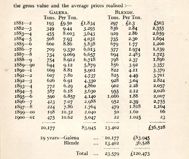 click to enlarge click to enlargePST3Tab3.jpg "During the twenty years covered by the figures of the output the mine gave employment to an average of 100 men and boys." |
|
|
|
||
| evidence:- | old map:- Postlethwaite 1877 (3rd edn 1913) placename:- Threlkeld Mine |
|
| source data:- | Map, uncoloured engraving, Map of the Lake District Mining Field, Westmorland, Cumberland,
Lancashire, scale about 5 miles to 1 inch, by John Postlethwaite, published by W H
Moss and Sons, 13 Lowther Street, Whitehaven, Cumberland, 1877 edn 1913.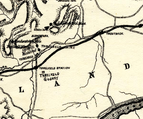 PST2NY32.jpg "THRELKELD MINE" no symbol item:- JandMN : 162.2 Image © see bottom of page |
|
|
|
||
| evidence:- | mine plan:- Postlethwaite 1877 placename:- Threlkeld Mine |
|
| source data:- | Print, drawing, mine section, Threlkeld Lead Mines, Threlkeld, Cumberland, published
by W H Moss and Sons, 13 Lowther Street, Whitehaven, Cumberland, 1877 edn 1913.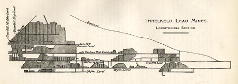 click to enlarge click to enlargePST320.jpg On p.97 of Mines and Mining in the English Lake District, by John Postlethwaite. printed, upper right "THRELKELD LEAD MINES. / LONGITUDINAL SECTION" item:- JandMN : 162.22 Image © see bottom of page |
|
|
|
||
| evidence:- | mine plan:- Postlethwaite 1877 placename:- Threlkeld Mine |
|
| source data:- | Print, drawing, simplified mine section showing a fault, Threlkeld Mine, Threlkeld,
Cumberland, published by W H Moss and Sons, 13 Lowther Street, Whitehaven, Cumberland,
1877 edn 1913.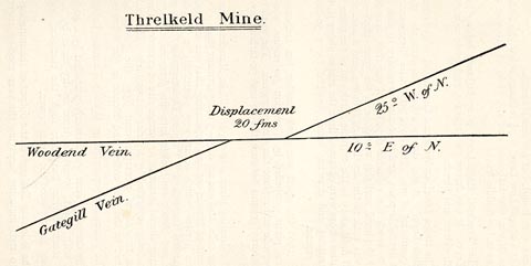 click to enlarge click to enlargePST321.jpg On p.99 of Mines and Mining in the English Lake District, by John Postlethwaite. printed, upper centre "Threlkeld Mine." item:- JandMN : 162.23 Image © see bottom of page |
|
|
|
||
| evidence:- | visit log:- KDMRS 1979-82 placename:- Threlkeld Mine item:- galena; blende |
|
| source data:- | Notes, log book of Geological Outings, mine plans, etc, Kendal
and District Mine Research Society, Kendal area, Cumbria, etc,
visits made 1979-82. Geological Outing of the Kendal and District Mine Research Society Log book page 104:- "DATE - 20/9/81 / MAP REF - 3250/2600. / LOCATION - THRELKELD / NAME - THRELKELD MINE / TYPE OF SITE - MINE / WORKING OR DISUSED - DISUSED / PEOPLE IN PARTY [ ] / NOS. OF PHOTOS - 59 / SPECIMENS FOUND - SMALL PIECES OF GALENA &BLENDE. / COMMENTS - WET, WINDY DAY! SIX LEVELS VISIBLE, FIVE ENTERABLE. BOTTOM LEVEL (HORSE LEVEL) IS FOUND BELOW DAM, AND THIS IS QUITE SHALLOW WATER, AND HEAVILY IRON STAINED. THIS LEVEL WAS ENTERED FOR A SHORT DISTANCE BUT SOME ROOF FALLS WERE ENCOUNTERED AND ANOTHER VISIT IS PROPOSED FOR THIS LEVEL. THE HIGHER LEVELS ARE QUITE INTERESTING HAVING STOPING AND SHAFTS. ONE LEVEL HAS A SHAFT IN IT OF SOME CONSIDERABLE DEPTH 100FT+? BUT WAS NOT ATTEMPTED AT THIS TIME. INTERESTING DAY ALTHOUGH WET." item:- private collection : 82 Image © see bottom of page |
|
|
|
||
 BWD83.jpg Weir on Gate Gill, (taken 26.3.2012) 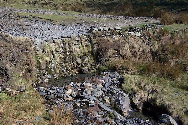 BWD84.jpg Weir on Gate Gill (taken 26.3.2012) |
||
|
|
||
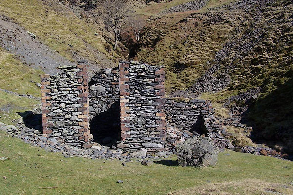 BWD85.jpg Building at (taken 26.3.2012) 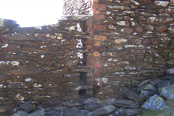 BWD86.jpg Building at (taken 26.3.2012) 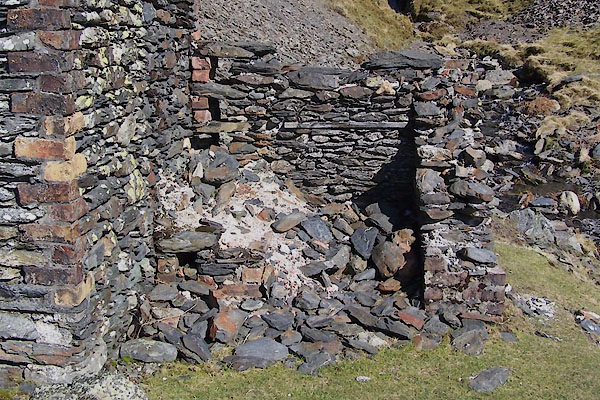 BWD87.jpg Building at (taken 26.3.2012) |
||
|
|
||
| :- |
Foot of Hall's Fell. Beginning not know, perhaps 17th century; very productive 1870s
to 1920s. |
|
| Woodend Vein and Gategill Vein, galena, blende and iron pyrite. |
||
| Adams, John: 1988: Mines of the Lake District Fells: Dalesman Books (Lancaster, Lancashire)::
ISBN 0 85206 931 6 |
||
|
|
||
Lakes Guides menu.