 Old Cumbria Gazetteer
 |
 |
|
| Walla Crag, Borrowdale | ||
| Walla Crag | ||
| civil parish:- | St John's Castlerigg and Wythburn (formerly Cumberland) | |
| county:- | Cumbria | |
| locality type:- | rocks | |
| coordinates:- | NY27672140 (etc) | |
| 1Km square:- | NY2721 | |
| 10Km square:- | NY22 | |
|
|
||
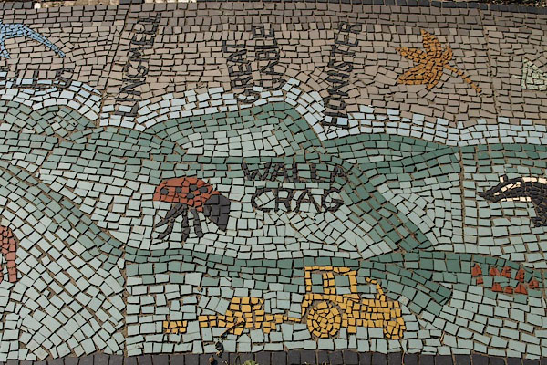 BPR19.jpg Mosaic outline view at Blencathra Field Studies Centre, detail. (taken 26.9.2008) 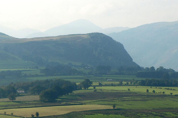 BPR20.jpg Walla Crag from Blencathra Field Studies Centre; Great Gable lies behind; Castlerigg Stone Circle can be seen in a field in front. (taken 26.9.2008) |
||
|
|
||
| evidence:- | old map:- OS County Series (Cmd 64 10) placename:- Wallow Crag |
|
| source data:- | Maps, County Series maps of Great Britain, scales 6 and 25
inches to 1 mile, published by the Ordnance Survey, Southampton,
Hampshire, from about 1863 to 1948. |
|
|
|
||
| evidence:- | descriptive text:- West 1778 (11th edn 1821) placename:- Wallow Cragg |
|
| source data:- | Guide book, A Guide to the Lakes, by Thomas West, published by
William Pennington, Kendal, Cumbria once Westmorland, and in
London, 1778 to 1821. goto source goto sourceAddendum; Mr Gray's Journal, 1769 Page 203:- "Oct. 3. [at Keswick] A heavenly day; rose at seven, and walked out under the conduct of my landlord to Borrowdale; ... drew near the foot of Wallow-cragg, whose bare and rugged brow, cut perpendicularly down above 400 feet, (as I guess, though the people call it much more) awfully overlooks the way. ..." goto sourcePage 208:- "[from Fawe Park] ... in front rises Wallow-crag and Castle-hill, the town, the road to Penrith, Skiddaw, and Saddleback. ..." goto sourceMr Cumberland's Ode to the Sun, 1776 Page 226:- "... / And you, triumphal arches, shrink; / Ye temples, tremble; and ye columns, sink; / One nod from Wallow's craggy brow / Shall crush the dome / Of sacerdotal Rome, / And lay her glitt'ring gilded trophies low." |
|
|
|
||
| evidence:- | old text:- Clarke 1787 placename:- Wallow Cragg |
|
| source data:- | Guide book, A Survey of the Lakes of Cumberland, Westmorland,
and Lancashire, written and published by James Clarke, Penrith,
Cumberland, and in London etc, 1787; published 1787-93. goto source Page 71:- "From the station we have last described there is a grand view of Wallow-Cragg, a most stupendous bare rock, situated at the high end of Keswick Parks: this is the only good view of it; for if we view it from the opposite shore, the distance away takes too much from its height; and if we stand underneath, it is too terrible to be viewed with pleasure. The height of this enormous mass of stone is 1500 feet, and is so perpendicular, that a man may from the top throw a stone into the Lake. I always recommend both the traveller and painter to view these mountains from the Lake; he may anchor here in five fathoms water; and that I might, (as far as I could,) contribute to his pleasure and convenience, I have sounded the Lake in many places, and marked the soundings in the plan." |
|
|
|
||
| evidence:- | old print:- Green 1810 (plate 30) |
|
| source data:- | Print, soft ground etching, Derwent Water from Castlerigg, St John's Castlerigg and
Wythburn, Cumberland, by William Green, Ambleside, Westmorland, 1809.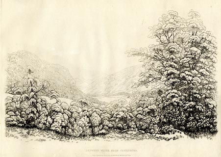 click to enlarge click to enlargeGN1230.jpg Walla Crag on the left. Plate 30 in Sixty Studies from Nature, 1810. printed at top right:- "[30]" printed at bottom:- "DERWENT WATER FROM CASTLERIGG. / Drawn &Engraved by William Green, and Published at Ambleside, Augst. 1st. 1809." watermark:- "J WHATMAN / 1813" item:- Armitt Library : A6641.30 Image © see bottom of page |
|
|
|
||
| evidence:- | descriptive text:- Otley 1823 (5th edn 1834) placename:- Wallow Crag item:- geology |
|
| source data:- | Guide book, A Concise Description of the English Lakes, the
mountains in their vicinity, and the roads by which they may be
visited, with remarks on the mineralogy and geology of the
district, by Jonathan Otley, published by the author, Keswick,
Cumberland now Cumbria, by J Richardson, London, and by Arthur
Foster, Kirkby Lonsdale, Cumbria, 1823; published 1823-49,
latterly as the Descriptive Guide to the English Lakes. goto source Page 120:- "... rising ground, over which Wallow Crag shews" goto sourcePage 121:- "his massive rocky front; ..." "..." goto sourcePage 156:- "... the more compact dark-coloured rock of Wallow Crag, in which quartz, calcareous spar, chlorite, and epidote, are found in veins. ..." |
|
|
|
||
| evidence:- | descriptive text:- Ford 1839 (3rd edn 1843) placename:- Wallow Crag |
|
| source data:- | Guide book, A Description of Scenery in the Lake District, by
Rev William Ford, published by Charles Thurnam, Carlisle, by W
Edwards, 12 Ave Maria Lane, Charles Tilt, Fleet Street, William
Smith, 113 Fleet Street, London, by Currie and Bowman,
Newcastle, by Bancks and Co, Manchester, by Oliver and Boyd,
Edinburgh, and by Sinclair, Dumfries, 1839. goto source Page 59:- "..." "CASTLEHEAD AND WALLOW CRAG." "There is a beautiful and entertaining walk to the summit of these, which is gained by proceeding" goto sourcePage 59:- "a short distance on the Borrowdale road, and then turning up the woods to the left. At the commencement is a superb view of Keswick, the church, and Bassenthwaite. On the top are benches, where you may rest, and look over the soft bosom of the lake full into the gorge of Borrowdale, which is the grandest aspect. To the north is Bassenthwaite Water and the stately Skiddaw." |
|
|
|
||
| evidence:- | outline view:- Martineau 1855 placename:- Wallow Crag |
|
| source data:- | Print, engraving, outline view, Mountains seen from Applethwaite near Keswick, drawn
by L Aspland, engraved by W Banks, Edinburgh, published by John Garnett, Windermere,
Westmorland, and by Whittaker and Co, London, 1855.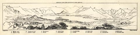 click to enlarge click to enlargeMNU114.jpg Folded in opposite p.93 in A Complete Guide to the English Lakes, by Harriet Martineau. "MOUNTAINS SEEN FROM APPLETHWAITE NEAR KESWICK." "L Aspland Delt. / W Banks Sc Edinr." The view is captioned, numbers referring to mountains in the image:- "1 Wallow Crag, 2 Falcon Crag, 3 Shepherd's Crag / Lowdore below, 4 Glaramara, 5 Brund, 6 Castle Crag, 7 Great End, 8 Scawfell Pike, 9 Catbell, 10, High Stile, 11 Red Pike, 12 Grasmoor, 13 Causey Pike, 14 Melbreak, 15 Grisdale Pike" item:- Armitt Library : A1159.14 Image © see bottom of page |
|
|
|
||
| evidence:- | old postcard:- placename:- Walla Crag |
|
| source data:- | Postcard, colour printed photograph, Friars Crag and Walla Crag, Keswick area, Cumberland,
published mid 20th century?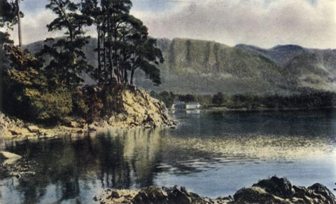 click to enlarge click to enlargePH0088.jpg printed at bottom:- "FRIARS CRAG AND WALLA CRAG, DERWENTWATER" item:- JandMN : 956 Image © see bottom of page |
|
|
|
||
| evidence:- | outline view:- Jenkinson 1875 placename:- Wallow Crag |
|
| source data:- | Print, lithograph, outline view, Panoramic Sketches from Scawfell Pike, Cumberland,
by Edwin A Pettitt, London, published by Edward Stanford, 55 Charing Cross, London,
1875.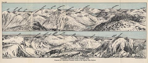 click to enlarge click to enlargeJk01E3.jpg "... Wallow Crag ..." item:- JandMN : 28.9 Image © see bottom of page |
|
|
|
||
| evidence:- | outline view:- Matthew 1866 placename:- Wallow Crag |
|
| source data:- | Print, engraving, outline view, View from Watendlath Road of Derwent Water and Bassenthwaite,
Cumberland, published by J Richardson, Highgate, Kendal, Westmorland, 1866.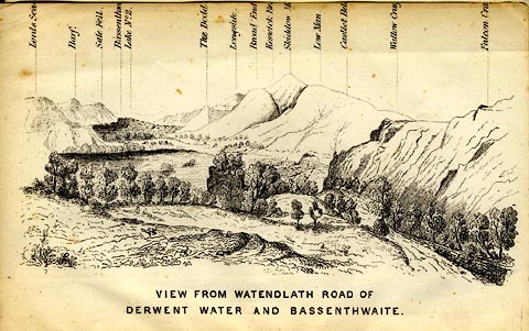 click to enlarge click to enlargeMW1E05.jpg Tipped in before p.1 of The English Lakes, Peaks and Passes, from Kendal to Keswick, by George King Matthew. printed at bottom:- "VIEW FROM WATENDLATH ROAD OF / DERWENT WATER AND BASSENTHWAITE." printed at caption to mountains:- "... Wallow Cra[g ] ..." item:- Armitt Library : A1168.5 Image © see bottom of page |
|
|
|
||
| evidence:- | outline view:- Black 1856 (23rd edn 1900) placename:- Wallow Crag |
|
| source data:- | Print, lithograph, Outline Views, Skiddaw and Derwent Water - Mountains as seen at
Lodore Hotel, and Mountains as seen at the Third Gate on Ascending Latrigg on the
Way to Skiddaw, by J Flintoft, Keswick, Cumberland, engraved by R Mason, Edinburgh,
Lothian, about 1900.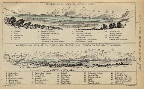 click to enlarge click to enlargeBC08E4.jpg "... 1 Wallow Crag ..." item:- JandMN : 37.14 Image © see bottom of page |
|
|
|
||
| evidence:- | outline view:- Black 1841 (3rd edn 1846) placename:- Wallow Crag |
|
| source data:- | Print, engraving, outline view, Mountains as seen at Lowdore Inn, and Mountains as
seen at the Third Gate on Ascending Latrigg on the Way to Skiddaw, by J Flintoft,
Keswick, Cumberland, engraved by R Mason, Edinburgh, Lothian, about 1846.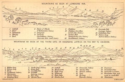 click to enlarge click to enlargeBC02E4.jpg "... 1 Wallow Crag ..." item:- JandMN : 32.7 Image © see bottom of page |
|
|
|
||
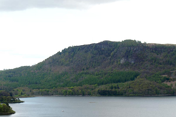 BYI34.jpg (taken 17.5.2013) 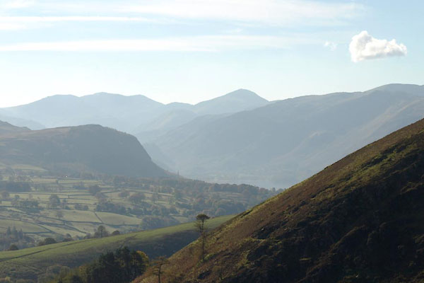 BXN93.jpg (taken 21.10.2012) |
||
|
|
||
Lakes Guides menu.