 Old Cumbria Gazetteer
 |
 |
|
| Wallow Crag, Shap Rural | ||
| Wallow Crag | ||
| civil parish:- | Shap Rural (formerly Westmorland) | |
| county:- | Cumbria | |
| locality type:- | rocks | |
| coordinates:- | NY49531514 | |
| 1Km square:- | NY4914 | |
| 10Km square:- | NY41 | |
|
|
||
| evidence:- | old text:- Clarke 1787 placename:- Wallow Cragg item:- eagle; fish |
|
| source data:- | Guide book, A Survey of the Lakes of Cumberland, Westmorland,
and Lancashire, written and published by James Clarke, Penrith,
Cumberland, and in London etc, 1787; published 1787-93. goto source goto sourcePage 189:- "..." "... At the robbing of an eagle's nest at Wallow Cragg near Haws-water in Westmorland, there were found 35 fish, besides 7 lambs, and other provisions for the young ones; they never have more than two at a time, and many of them breed in these mountains every year. It hath been said by some that they come from Ireland hither to breed, and when the young one are of sufficient strength, they return with them to Ireland again: this assertion I deny, as I have seen them at every season of the year, though they are seldomer seen in Summer than in Winter, when the snow forces them down to the vallies to seek provisions. The lesser eagles are not so common, and are known from the buzzard by their head being less, their neck longer, and their voice. ..." |
|
|
|
||
| evidence:- | outline view:- Otley 1823 (8th edn 1849) placename:- Wallow Crag |
|
| source data:- | Engraving, outline view of mountains, Hawes Water from Measand Beck, drawn by T Binns,
engraved by O Jewitt, opposite p.16 of A Descriptive Guide of the English Lakes, by
Jonathan Otley, 8th edition, 1849.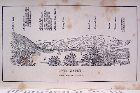 click to enlarge click to enlargeO80E09.jpg item:- Armitt Library : A1180.10 Image © see bottom of page |
|
|
|
||
| evidence:- | descriptive text:- Otley 1823 (5th edn 1834) |
|
| source data:- | Guide book, A Concise Description of the English Lakes, the
mountains in their vicinity, and the roads by which they may be
visited, with remarks on the mineralogy and geology of the
district, by Jonathan Otley, published by the author, Keswick,
Cumberland now Cumbria, by J Richardson, London, and by Arthur
Foster, Kirkby Lonsdale, Cumbria, 1823; published 1823-49,
latterly as the Descriptive Guide to the English Lakes. goto source Page 28:- "... Its [Hawes Water's] eastern side is bounded by Naddle Forest, the lower part completely wooded, and surmounted by the lofty Wallow Crag; beyond which the hill side is scattered with aged thorns." |
|
|
|
||
| evidence:- | outline view:- Black 1856 (23rd edn 1900) placename:- Wallow Crag |
|
| source data:- | Print, lithograph, Outline Views, Haws and Wastwater - Mountains as seen from Burn-Banks
near the Foot of Hawes Water, and Mountains as seen near Nether Wastdale at the First
Bridge on the road to Wast-Water, by J Flintoft, Keswick, Cumberland, engraved by
R Mason, Edinburgh, Lothian, about 1900.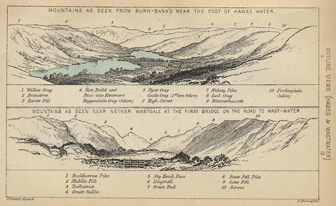 click to enlarge click to enlargeBC08E6.jpg "... 1 Wallow Crag ..." item:- JandMN : 37.21 Image © see bottom of page |
|
|
|
||
| evidence:- | outline view:- Black 1841 (3rd edn 1846) placename:- Wallow Crag |
|
| source data:- | Print, engraving, outline view, Mountains as seen from Burn Banks near the Foot of
Hawes Water, and Mountains as seen near Strands in Wastdale at the First bridge on
the Road to Wast Water, by J Flintoft, Keswick, Cumberland, engraved by R Mason, Edinburgh,
Lothian, about 1846.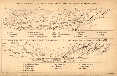 click to enlarge click to enlargeBC02E8.jpg "... 1 Wallow Crag ..." item:- JandMN : 32.12 Image © see bottom of page |
|
|
|
||
| evidence:- | outline view:- Tattersall 1836 (version 1869) placename:- Wallow Crag |
|
| source data:- | Print, hand coloured, Hawes Water, from Thwaite Force, Westmorland, drawn by George
Tattersall, 1836, engraved by W F Topham, published by T J Allman, 463 Oxford Street,
London, 1869.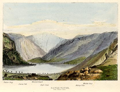 click to enlarge click to enlargeTAT217.jpg Included in The Lakes of England, by W F Topham. printed at bottom:- "HAWES-WATER, / from Thwaite Force." printed at bottom:- "Wallow Crag. / Harter Fell. / Mardale Chapel. / High Street. / Kidsay Pike. / Whelter Crag." item:- Armitt Library : A1067.17 Image © see bottom of page |
|
|
|
||
| evidence:- | outline view:- Tattersall 1836 placename:- Wallow Crag |
|
| source data:- | Print, engraving, Hawes Water, from Thwaite Force, Westmorland, drawn by George Tattersall,
engraved by W F Topham, published by Sherwood and Co, Paternoster Row, London, about
1836.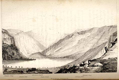 click to enlarge click to enlargeTAT139.jpg The print is captioned with mountain names and acts as an outline view. Tipped in opposite p.109 of The Lakes of England, by George Tattersall. printed at bottom:- "HAWES-WATER, / from Thwaite Force." printed at bottom left to right:- "Wallow Crag. / Harter Fell. / Mardale Chapel. / High Street. / Kidsay Pike. / Whelter Crag." item:- Armitt Library : A1204.40 Image © see bottom of page |
|
|
|
||
| story:- |
As Charles Williams was born in Mardale, a large boulder fell from Wallow Crag into
Haweswater. The parents thought this an ill omen, and declared their son would drown.
In his youth, Charles saved a girl, Maria, from a bull, and they fell in love. Before
they could marry, she became ill and died. The sad Charles drowned himself by Wallow
Crag; his last poem:- |
|
| "And what is death, that I should dread To mingle with the silent dead? 'Tis but a pang - and pangs are o'er; A throb - and throbbing is no more; One struggle - and that one my last; A gasp - a groan - and all is past!" |
||
|
|
||
Lakes Guides menu.