 Old Cumbria Gazetteer
 |
 |
|
| Swindale Chapel, Swindale | ||
| gone | ||
| Swindale Chapel | ||
| Swindale School | ||
| locality:- | Truss Gap | |
| locality:- | Swindale | |
| civil parish:- | Shap Rural (formerly Westmorland) | |
| county:- | Cumbria | |
| locality type:- | church | |
| locality type:- | school | |
| coordinates:- | NY51311309 | |
| 1Km square:- | NY5113 | |
| 10Km square:- | NY51 | |
| references:- | OS County Series |
|
|
|
||
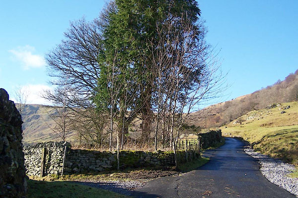 BUA60.jpg This seems to be the site. (taken 11.2.2011) |
||
|
|
||
| evidence:- | old map:- OS County Series (Wmd 20) |
|
| source data:- | Maps, County Series maps of Great Britain, scales 6 and 25
inches to 1 mile, published by the Ordnance Survey, Southampton,
Hampshire, from about 1863 to 1948. "Endowed School" "Church (Per Curacy)" at Truss Gap, together? |
|
|
|
||
| evidence:- | old map:- Jefferys 1770 (Wmd) |
|
| source data:- | Map, 4 sheets, The County of Westmoreland, scale 1 inch to 1
mile, surveyed 1768, and engraved and published by Thomas
Jefferys, London, 1770. J5NY51SW.jpg "Chap:" chapel item:- National Library of Scotland : EME.s.47 Image © National Library of Scotland |
|
|
|
||
| evidence:- | old map:- Cary 1789 (edn 1805) |
|
| source data:- | Map, uncoloured engraving, Westmoreland, scale about 2.5 miles
to 1 inch, by John Cary, London, 1789; edition 1805. CY24NY51.jpg "Chap" church symbol; church or chapel item:- JandMN : 129 Image © see bottom of page |
|
|
|
||
| evidence:- | old map:- Otley 1818 |
|
| source data:- | Map, uncoloured engraving, The District of the Lakes,
Cumberland, Westmorland, and Lancashire, scale about 4 miles to
1 inch, by Jonathan Otley, 1818, engraved by J and G Menzies,
Edinburgh, Scotland, published by Jonathan Otley, Keswick,
Cumberland, et al, 1833. OT02NY51.jpg Marked by a cross. item:- JandMN : 48.1 Image © see bottom of page |
|
|
|
||
| evidence:- | old text:- Gents Mag |
|
| source data:- | Magazine, The Gentleman's Magazine or Monthly Intelligencer or
Historical Chronicle, published by Edward Cave under the
pseudonym Sylvanus Urban, and by other publishers, London,
monthly from 1731 to 1922. goto source goto sourceGentleman's Magazine 1823 part 2 p.325 "SWINDALE, in the parish of Shap, founded in 1703, by Thomas Baxter of Truss Gap in this place, who gave to it an estate, consisting between two and three hundred acres of land, called Wastdale Foot, adjoining the Spa of Shapwells. The trustees, in 1750, improperly sold it to John Brown of Wastdale Head, subject to a rent charge of 10l. a year; he sold it along with his estate of Wastdale Head to the the late Sir James Lowther, who, about the year 1775, from some cause or other, refused the payment of this 10l. a year, and witheld it during his life; but when the present William Earl of Lonsdale came to the Lowther estates in 1802, he agreed with the trustess henceforth to allow 25l. a year out of the Wastdale Foot estate, instead of paying up the arrears due from his predecessor." |
|
|
|
||
| evidence:- | old map:- Nurse 1918 |
|
| source data:- | Map, The Diocese of Carlisle, Cumberland, Westmorland, and
Lancashire North of the Sands, scale about 4 miles to 1 inch, by
Rev Euston J Nurse, published by Charles Thurnam and Sons, 11
English Street, Carlisle, Cumberland, 2nd edn 1939.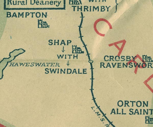 NUR1NY51.jpg "SHAP WITH SWINDALE" item:- JandMN : 27 Image © see bottom of page |
|
|
|
||
| evidence:- | site plan:- Historical Monuments 1936 |
|
| source data:- | Site plan, uncoloured lithograph, Swindale Chapel, Shap Rural, Westmorland, scale
about 1 to 290? published by Royal Commission on Historical Monuments England, London,
1936.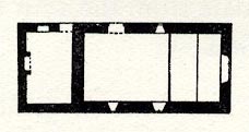 click to enlarge click to enlargeHMW123.jpg On p.207 of the Inventory of the Historical Monuments in Westmorland. RCHME no. Wmd, Shap Rural 2 item:- Armitt Library : A745.124 Image © see bottom of page |
|
|
|
||
| hearsay:- |
... a school and church in one tiny building, which is divided amidships. You prayed
at one end and learnt your three R's at the other. ... |
|
|
|
||
Lakes Guides menu.