 Old Cumbria Gazetteer
 |
 |
|
| viewpoint, Rayrigg Bank | ||
| site name:- | Rayrigg Bank | |
| locality:- | Windermere | |
| civil parish:- | Windermere (formerly Westmorland) | |
| county:- | Cumbria | |
| locality type:- | viewpoint | |
| coordinates:- | SD401982 | |
| 1Km square:- | SD4098 | |
| 10Km square:- | SD49 | |
|
|
||
| evidence:- | descriptive text:- Otley 1823 (5th edn 1834) |
|
| source data:- | Guide book, A Concise Description of the English Lakes, the
mountains in their vicinity, and the roads by which they may be
visited, with remarks on the mineralogy and geology of the
district, by Jonathan Otley, published by the author, Keswick,
Cumberland now Cumbria, by J Richardson, London, and by Arthur
Foster, Kirkby Lonsdale, Cumbria, 1823; published 1823-49,
latterly as the Descriptive Guide to the English Lakes. goto source goto sourcePage 5:- "... Rayrigg-Bank has the most complete view of the whole lake. ..." |
|
|
|
||
| evidence:- | old print with text:- Farington 1789 (plate 19) placename:- Rarig item:- cattle |
|
| source data:- | Print, engraving, View looking down Windermere, taken above Rarig ie Rayrigg, Lakes,
Cumbria, painted by Joseph Farington, engraved by W Byrne and T Medland, published
by W Byrne, 69 Titchfield Street, London, 1789.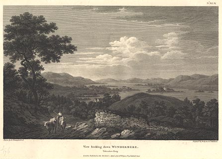 click to enlarge click to enlargeBMZ09.jpg A farmer on horseback drives cattle up Rayrigg Bank in the foreground, Belle Isle is clear in the lake. Plate 19 from Views of the Lakes, &c, in Cumberland and Westmorland, published 1789; with descriptive text:- "VIEW looking down WINDERMERE from above RARIG. ... Rarig, which lies below, is placed near the Road leading from Bowness to Ambleside, and is a Situation much admired for the many beautiful Points of View which are found in its Vicinity." item:- Dove Cottage : Lowther.10 Image © see bottom of page |
|
|
|
||
Lakes Guides menu.