 Old Cumbria Gazetteer
 |
 |
|
| viewpoint, Stockhow | ||
| locality:- | Stockhow (?) | |
| civil parish:- | Lamplugh (formerly Cumberland) | |
| county:- | Cumbria | |
| locality type:- | viewpoint | |
| coordinates:- | NY065170 (about) | |
| 1Km square:- | NY0617 | |
| 10Km square:- | NY01 | |
|
|
||
| evidence:- | outline view:- Otley 1823 (4th edn 1830) |
|
| source data:- | Print, engraving, outline view, Mountains of Ennerdale as seen from Kirkland, published
by Jonathan Otley, Keswick, Cumberland et al, 1830.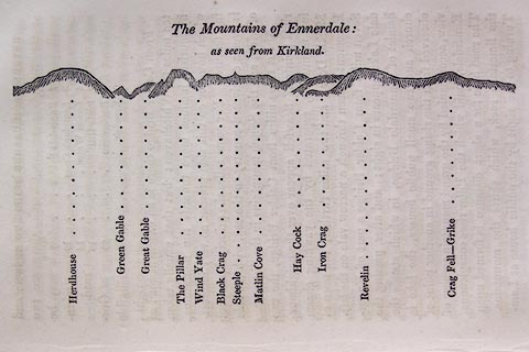 click to enlarge click to enlargeO75E09.jpg p.131 in A Concise Description of the English Lakes, by Jonathan Otley, 4th edition, 1830. printed at top:- "The Mountains of Ennerdale: / as seen from Kirkland." printed at bottom:- "Herdhouse / Green Gable / Great Gable / The Pillar / Wind Yate / Black Crag / Steeple / Matlin Cove / Hay Cock / Iron Crag / Revelin / Crag Fell - Grike" item:- Armitt Library : A1175.9 Image © see bottom of page |
|
|
|
||
| evidence:- | outline view:- Otley 1823 (5th edn 1834) |
|
| source data:- | Print, woodcut outline view, The Mountains of Ennerdale, by Jonathan Otley, Keswick,
Cumberland now Cumbria, 1834.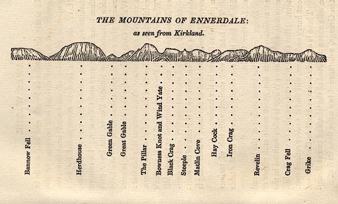 click to enlarge click to enlargeOT2E06.jpg Printed on p.27 of A Concise Description of the English Lakes, by Jonathan Otley, 5th edition, 1834. printed at top:- "THE MOUNTAINS OF ENNERDALE: / as seen from Kirkland." printed at bottom:- "Bannow Fell / Herdhouse / Green Gable / Great Gable / The Pillar / Bowness Knot and Wind Yate / Black Crag / Steeple / Matlin Cove / Hay Cock / Iron Crag / Revelin / Crag Fell / Grike" item:- JandMN : 48.7 Image © see bottom of page |
|
|
|
||
| evidence:- | outline view:- Otley 1823 (8th edn 1849) |
|
| source data:- | Print, engraving, outline view of mountains, Ennerdale from a Field near Kirkland
and Salter, drawn by Mr Binns, Halifax, engraved by Mr Jewitt, Headington, Oxfordshire,
published by Jonathan Otley, Keswick, Cumberland et al, 1849.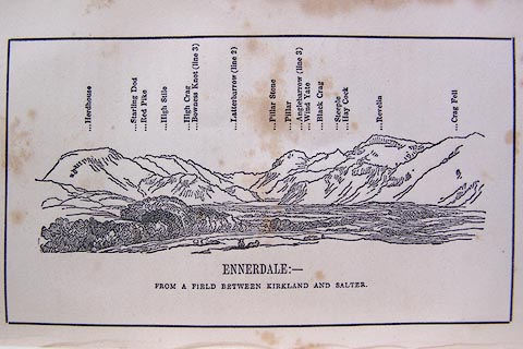 click to enlarge click to enlargeO80E11.jpg Opposite p.20 of A Descriptive Guide of the English Lakes, by Jonathan Otley, 8th edition, 1849. printed at bottom:- "ENNERDALE: - / FROM A FIELD BETWEEN KIRKLAND AND SALTER." printed at top:- "Herdhouse / Starling Dod / Red Pike / High Stile / High Crag / Bowness Knot (line 3) / Latterbarrow (line 2) / Pillar Stone / Pillar / Anglebarrow (line 3) / Wind Yate / Black Crag / Steeple / Hay Cock / Revelin/ Crag Fell" Looking ESE; 45 degree view, E to SE. item:- Armitt Library : A1180.12 Image © see bottom of page |
|
|
|
||
 Lakes Guides menu.