 Old Cumbria Gazetteer
 |
 |
|
| milestone, St John's Castlerigg etc (5) | ||
| site name:- | road, Ambleside to Keswick | |
| locality:- | Thirlspot | |
| civil parish:- | St John's Castlerigg and Wythburn (formerly Cumberland) | |
| county:- | Cumbria | |
| locality type:- | milestone | |
| coordinates:- | NY31601730 (roughly) | |
| 1Km square:- | NY3117 | |
| 10Km square:- | NY31 | |
|
|
||
| evidence:- | old map:- OS County Series (Cmd 70) |
|
| source data:- | Maps, County Series maps of Great Britain, scales 6 and 25
inches to 1 mile, published by the Ordnance Survey, Southampton,
Hampshire, from about 1863 to 1948. "M.S. KESWICK 6 AMBLESIDE 10" |
|
|
|
||
| evidence:- | old print with text:- Farington 1789 (plate 18) |
|
| source data:- | Print, engraving, View on the Road Leading from Ambleside to Keswick, painted by Joseph
Farington, engraved by W Byrne and J Landseer, published by W Byrne, 79 Titchfield
Street, London, 1789.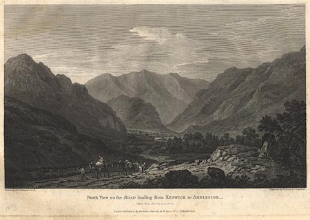 click to enlarge click to enlargeBMZ86.jpg Plate 18 from Views of the Lakes, &c, in Cumberland and Westmorland, published 1789; with descriptive text:- "North View on the ROAD leading from KESWICK to AMBLESIDE. Taken from the Six mile stone." "... The Road passes a considerable Way on the Margin of that Lake [Thirlemere], when it becomes again steep and winding; but the Tediousness of Alpine travelling is compensated by the Scene which opens from the Six Mile Stone, on this Side Keswick. ..." item:- Dove Cottage : Lowther.49 Image © see bottom of page |
|
|
|
||
 Lakes Guides menu.