 Old Cumbria Gazetteer
 |
 |
|
| Quayfoot Quarry, Borrowdale | ||
| Quayfoot Quarry | ||
| Queyfoot Quarry | ||
| civil parish:- | Borrowdale (formerly Cumberland) | |
| county:- | Cumbria | |
| locality type:- | quarry | |
| coordinates:- | NY25361678 (etc) | |
| 1Km square:- | NY2516 | |
| 10Km square:- | NY21 | |
|
|
||
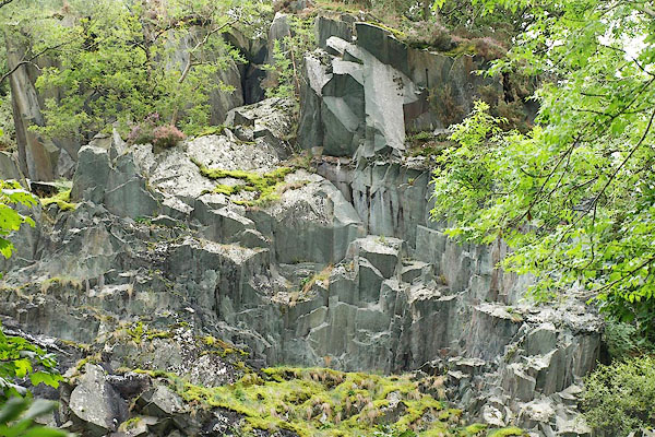 BPQ43.jpg Green slate quarry; horizontal bedding, vertical cleavage. (taken 24.8.2008) |
||
|
|
||
| evidence:- | old map:- OS County Series (Cmd 70 6) placename:- Quayfooot Quarries |
|
| source data:- | Maps, County Series maps of Great Britain, scales 6 and 25
inches to 1 mile, published by the Ordnance Survey, Southampton,
Hampshire, from about 1863 to 1948. |
|
|
|
||
| evidence:- | old text:- Postlethwaite 1877 (3rd edn 1913) placename:- Quayfoot Quarry item:- slate |
|
| source data:- | Book, Mines and Mining in the English Lake District, by John Postlethwaite, Keswick,
published by W H Moss and Sons, Whitehaven, Cumberland now Cumbria, 1877; published
1877-1913. goto source goto sourcepage 135:- "..." "Some of the beds of ash and breccia on the eastern side of the valley [Borroedale] are sufficiently cleaved in places to yield slate. The most important of these is the breccia worked at Quayfoot Quarry, near Grange. It has yielded a large quantity of slate of fairly good quality, although somewhat heavier than that obtained from the beds of slate metal. It has also yielded and is still yielding an abundant supply of strong, durable and very beautiful building stone." |
|
|
|
||
| evidence:- | old map:- Postlethwaite 1877 (3rd edn 1913) placename:- Queyfoot Quarry |
|
| source data:- | Map, uncoloured engraving, Map of the Lake District Mining Field, Westmorland, Cumberland,
Lancashire, scale about 5 miles to 1 inch, by John Postlethwaite, published by W H
Moss and Sons, 13 Lowther Street, Whitehaven, Cumberland, 1877 edn 1913.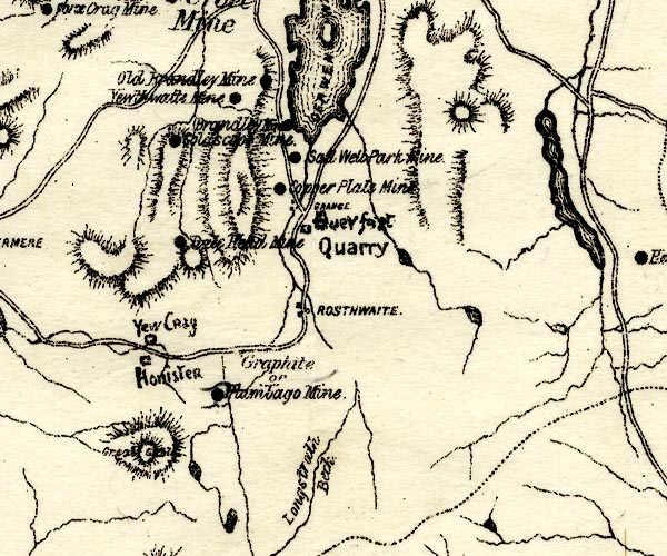 PST2NY21.jpg "Queyfoot Quarry" quarry symbol item:- JandMN : 162.2 Image © see bottom of page |
|
|
|
||
| evidence:- | visit log:- KDMRS 1979-82 placename:- Quayfoot Quarry |
|
| source data:- | Notes, log book of Geological Outings, mine plans, etc, Kendal
and District Mine Research Society, Kendal area, Cumbria, etc,
visits made 1979-82. Geological Outing of the Kendal and District Mine Research Society Log book page 53:- "DATE - 27/4/80 / MAP REF - 2540/1680 (BY21 1:25000) / LOCATION - QUAYFOOT QUARRY / NAME - QUAYFOOT QUARRY / TYPE OF SITE - QUARRY (SLATE) / WORKING OR DISUSED - DISUSED. / PEOPLE IN PARTY [ ] / NOS. OF PHOTOS - X / SPECIMENS FOUND - [blank] / COMMENTS - SOME LEVELS ENTERABLE. OPENING OUT INTO LARGE WORKED OUT CAVERNS, ONE EXTREMELY LARGE." item:- private collection : 82 Image © see bottom of page |
|
|
|
||
| Glover, David: 2014: Quarries of Lakeland: Bookcase (Carlisle, Cumbria) |
||
|
|
||
Lakes Guides menu.