 Old Cumbria Gazetteer
 |
 |
|
| milestone, Preston Richard | ||
| site name:- | road, Milnthorpe to Kirkby Lonsdale | |
| civil parish:- | Preston Richard (formerly Westmorland) | |
| county:- | Cumbria | |
| locality type:- | milestone | |
| coordinates:- | SD52438342 | |
| 1Km square:- | SD5283 | |
| 10Km square:- | SD58 | |
|
|
||
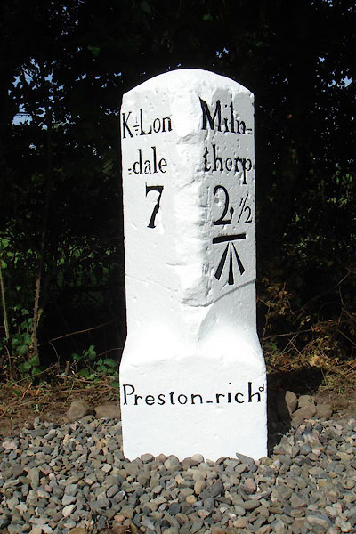 CGX66.jpg Inscribed stone:- "K=Lon / =dale / 7 / Miln= / thorp / 2½ / Preston-richd" (taken 11.2017) courtesy of David Gosling |
||
|
|
||
| evidence:- | old map:- OS County Series (Wmd 42 16) |
|
| source data:- | Maps, County Series maps of Great Britain, scales 6 and 25
inches to 1 mile, published by the Ordnance Survey, Southampton,
Hampshire, from about 1863 to 1948. "M.S. Milnthorpe .. 2 1/2 Kirkby Lonsdale .. 7" |
|
|
|
||
| evidence:- | database:- Listed Buildings 2010 |
|
| source data:- | courtesy of English Heritage "MILESTONE APPROXIMATELY 200 YARDS SOUTH WEST OF LANE FARM / / B6385 / PRESTON RICHARD / SOUTH LAKELAND / CUMBRIA / II / 76524 / SD5254483406" |
|
| source data:- | courtesy of English Heritage "Milestone. Probably early C19. Dressed limestone upright stone with round head and wide stop chamfers to front corners. Painted black and white and inscribed:" "K = Lon / = dale / 3 on West and" "Miln = / thorpe 2 1/2" "on East" "The 3 on the West side has been painted over with a 7 (the correct distance). Bench-mark on the East side. Worn inscription on base probably reads "To London"." |
|
|
|
||
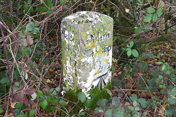 BOJ14.jpg Inscribed stone (before restoration) :- "K=Lon[ ] / =dale / 7 / Miln= / thorp / 2½" (taken 24.11.2007) |
||
|
|
||
 Lakes Guides menu.