 Old Cumbria Gazetteer
 |
 |
|
| Lawthwaite, Bampton | ||
| Lawthwaite | ||
| Laythwaite | ||
| locality:- | Bampton Common | |
| civil parish:- | Bampton (formerly Westmorland) | |
| county:- | Cumbria | |
| locality type:- | building/s (drowned) | |
| coordinates:- | NY479144 | |
| 1Km square:- | NY4714 | |
| 10Km square:- | NY41 | |
| references:- | Greenwood 1824 |
|
|
|
||
| evidence:- | old map:- Jefferys 1770 (Wmd) placename:- Laythwaite |
|
| source data:- | Map, 4 sheets, The County of Westmoreland, scale 1 inch to 1
mile, surveyed 1768, and engraved and published by Thomas
Jefferys, London, 1770.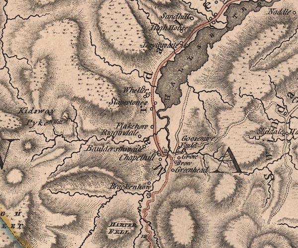 J5NY41SE.jpg "Laythwaite" circle, labelled in italic lowercase text; settlement, farm, house, or hamlet? item:- National Library of Scotland : EME.s.47 Image © National Library of Scotland |
|
|
|
||
| evidence:- | old map:- Cary 1789 (edn 1805) placename:- Laythwaite |
|
| source data:- | Map, uncoloured engraving, Westmoreland, scale about 2.5 miles
to 1 inch, by John Cary, London, 1789; edition 1805.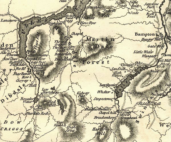 CY24NY41.jpg "Laythwaite" block/s, labelled in italic lowercase; house, or hamlet item:- JandMN : 129 Image © see bottom of page |
|
|
|
||
| evidence:- | old map:- Greenwood 1824 placename:- Lawthwaite |
|
| source data:- | Maps, Map of the County of Westmorland, scale about 1 inch to 1
mile, and Map of the County of Cumberland, scale about 1 inch to
1 mile, etc, by C and J Greenwood, published by George Pringle
jnr, 70 Queen Street, Cheapside, London, 1823 and 1824
respectively. "Lawthwaite" |
|
|
|
||
| evidence:- | old map:- Ford 1839 map placename:- Lowthwaite |
|
| source data:- | Map, uncoloured engraving, Map of the Lake District of
Cumberland, Westmoreland and Lancashire, scale about 3.5 miles
to 1 inch, published by Charles Thurnam, Carlisle, and by R
Groombridge, 5 Paternoster Row, London, 3rd edn 1843.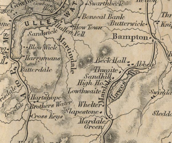 FD02NY41.jpg "Lowthwaite" item:- JandMN : 100.1 Image © see bottom of page |
|
|
|
||
 Lakes Guides menu.