 Old Cumbria Gazetteer
 |
 |
|
| Helsington Turnpike | ||
| site name:- | road, Milnthorpe to Kendal | |
| civil parish:- | Helsington (formerly Westmorland) | |
| county:- | Cumbria | |
| locality type:- | toll gate (site) | |
| coordinates:- | SD50669021 (?) | |
| 1Km square:- | SD5090 | |
| 10Km square:- | SD59 | |
| references:- | OS County Series |
|
|
|
||
| evidence:- | old map:- OS County Series (Wmd 38 12) |
|
| source data:- | Maps, County Series maps of Great Britain, scales 6 and 25
inches to 1 mile, published by the Ordnance Survey, Southampton,
Hampshire, from about 1863 to 1948. "Helsington T.P." gate across road, and a building |
|
|
|
||
| evidence:- | old map:- Jefferys 1770 (Wmd) |
|
| source data:- | Map, 4 sheets, The County of Westmoreland, scale 1 inch to 1
mile, surveyed 1768, and engraved and published by Thomas
Jefferys, London, 1770.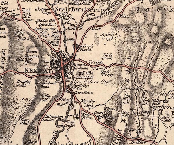 J5SD59SW.jpg "Toll Gate" circle; toll gate item:- National Library of Scotland : EME.s.47 Image © National Library of Scotland |
|
|
|
||
| evidence:- | old directory:- Parson and White 1829 |
|
| source data:- | Book, History, Directory, and Gazetteer, of the Counties of
Cumberland and Westmorland, with that Part of the Lake District
in Lancashire, forming the Lordships of Furness and Cartmel, by
William Parson and William White, published by W White and Co,
44 Hunslet Lane, Leeds, Yorkshire, 1829. Lists Henry Bell, collector at Helsington toll gate |
|
|
|
||
 Lakes Guides menu.