 Old Cumbria Gazetteer
 |
 |
|
| Mardale Green, Shap Rural | ||
| Mardale Green | ||
| locality:- | Mardale | |
| civil parish:- | Shap Rural (formerly Westmorland) | |
| county:- | Cumbria | |
| locality type:- | buildings | |
| locality type:- | locality | |
| coordinates:- | NY478117 (etc) | |
| 1Km square:- | NY4711 | |
| 10Km square:- | NY41 | |
|
|
||
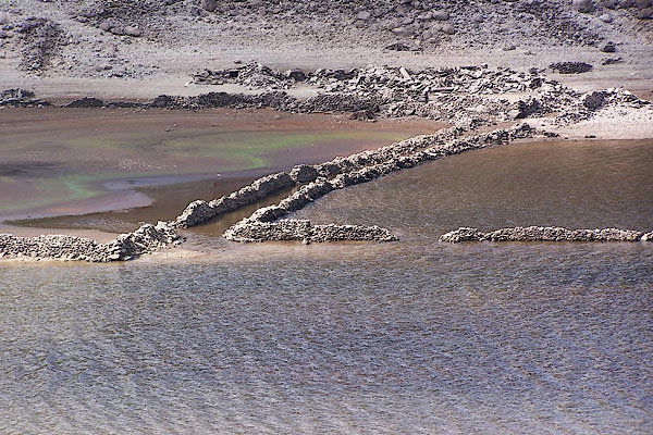 BJT69.jpg Signs of Mardale village, Haweswater about 10m low. (taken 22.8.2005) |
||
|
|
||
| evidence:- | old map:- OS County Series placename:- Mardale Green |
|
| source data:- | Maps, County Series maps of Great Britain, scales 6 and 25
inches to 1 mile, published by the Ordnance Survey, Southampton,
Hampshire, from about 1863 to 1948. |
|
|
|
||
| evidence:- | old map:- Otley 1818 placename:- Green |
|
| source data:- | Map, uncoloured engraving, The District of the Lakes,
Cumberland, Westmorland, and Lancashire, scale about 4 miles to
1 inch, by Jonathan Otley, 1818, engraved by J and G Menzies,
Edinburgh, Scotland, published by Jonathan Otley, Keswick,
Cumberland, et al, 1833.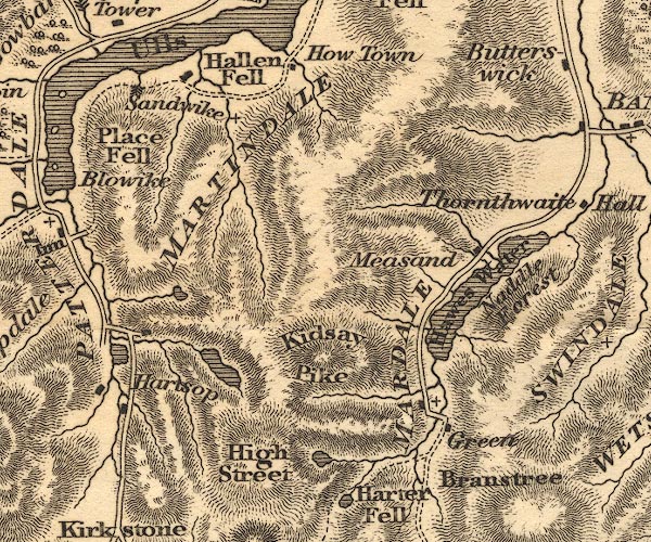 OT02NY41.jpg item:- JandMN : 48.1 Image © see bottom of page |
|
|
|
||
| evidence:- | descriptive text:- Otley 1823 (5th edn 1834) placename:- Mardale Green |
|
| source data:- | Guide book, A Concise Description of the English Lakes, the
mountains in their vicinity, and the roads by which they may be
visited, with remarks on the mineralogy and geology of the
district, by Jonathan Otley, published by the author, Keswick,
Cumberland now Cumbria, by J Richardson, London, and by Arthur
Foster, Kirkby Lonsdale, Cumbria, 1823; published 1823-49,
latterly as the Descriptive Guide to the English Lakes. goto source goto sourcePage 28:- "..." "There is a public house at Mardale Green, about a mile above the head of the lake [Hawes Water], and two at Bampton Grange, a distance of two miles from its foot." "..." goto sourcePage 115:- "Mardale Green, to which the road descends, is about 15 miles from Kendal, and the same from Penrith; it is bounded by the mountains Branstree, Harter Fell, and High Street. From the last of which a narrow ridge, called Long Stile, projects so far as to seclude it from the other parts of the valley; ... Here are two or three dwellings, one of which is a public-house; and the Dun Bull on Mardale Green will be no alarming or unwelcome object to the weary traveller." |
|
|
|
||
| evidence:- | descriptive text:- Ford 1839 (3rd edn 1843) |
|
| source data:- | Guide book, A Description of Scenery in the Lake District, by
Rev William Ford, published by Charles Thurnam, Carlisle, by W
Edwards, 12 Ave Maria Lane, Charles Tilt, Fleet Street, William
Smith, 113 Fleet Street, London, by Currie and Bowman,
Newcastle, by Bancks and Co, Manchester, by Oliver and Boyd,
Edinburgh, and by Sinclair, Dumfries, 1839. goto source Page 138:- "..." "About one mile further from the head of the lake stands Mardale Chapel, which is under Shap; it is a wild solitary region, surrounded by lofty mountains and fells. Near this, in former days, there stood 'a simple cottage among rocks, woods, and solitary mountains; it bore on its varied roofs and numerous gable-ends the marks of former centuries; its owners had lived there in succession for many generations. A few paces took them to Mardale Chapel, their place of worship, and when they died, their long home was on their own premises. They were surrounded by woody knolls, and these knlls were surrounded by lofty moun-" goto sourcePage 139:- "[moun]tains. Most of these remain, and will remain. I only regret that the ancient cottage, with its accompaniments, is superseded by the modern house with its five windows in front. I should have preferred at Mardale Hill the ancient cottage with its antiquated windows, its lowly roof fringed with moss, and its chimneys smoking through the trees, as the abode of quiet and the home of solitude.' The change here so eloquently lamented has, unfortunately, too often been the case in numerous other instances, which the stranger will have been obliged to notice." |
|
|
|
||
| evidence:- | old map:- Ford 1839 map placename:- Mardale Green |
|
| source data:- | Map, uncoloured engraving, Map of the Lake District of
Cumberland, Westmoreland and Lancashire, scale about 3.5 miles
to 1 inch, published by Charles Thurnam, Carlisle, and by R
Groombridge, 5 Paternoster Row, London, 3rd edn 1843.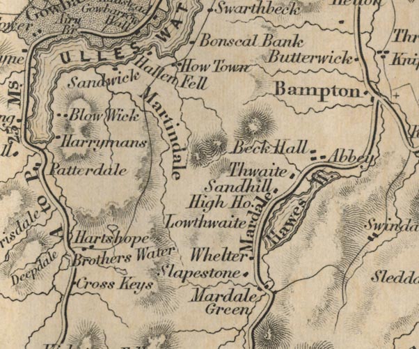 FD02NY41.jpg "Mardale Green" "Mardale" item:- JandMN : 100.1 Image © see bottom of page |
|
|
|
||
| evidence:- | old map:- Garnett 1850s-60s H placename:- Mardale Green |
|
| source data:- | Map of the English Lakes, in Cumberland, Westmorland and
Lancashire, scale about 3.5 miles to 1 inch, published by John
Garnett, Windermere, Westmorland, 1850s-60s.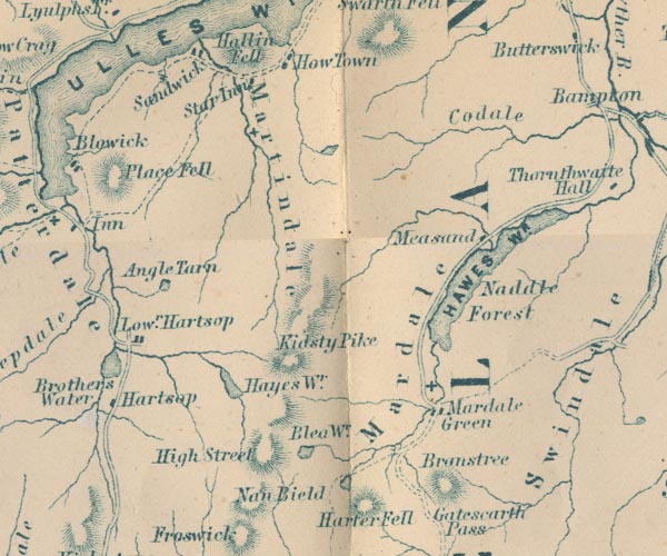 GAR2NY41.jpg "Mardale Green" blocks, settlement, and a cross, a church item:- JandMN : 82.1 Image © see bottom of page |
|
|
|
||
| evidence:- | old print:- Rose 1832-35 placename:- Mardale Green |
|
| source data:- | Print, engraving, Mardale Green, Westmorland, by Thomas Allom, engraved by R Sands,
1834.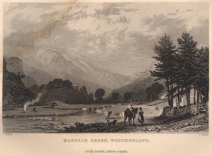 click to enlarge click to enlargeR267.jpg item:- JandMN : 66.49 Image © see bottom of page |
|
|
|
||
Lakes Guides menu.