 Old Cumbria Gazetteer
 |
 |
|
|
| road, Carlisle to Bowness-on-Solway | |||
| Carlisle to Bowness-on-Solway | |||
| Bowness-on-Solway to Carlisle | |||
| civil parish:- | Carlisle (formerly Cumberland) | ||
| civil parish:- | Beaumont (formerly Cumberland) | ||
| civil parish:- | Burgh by Sands (formerly Cumberland) | ||
| civil parish:- | Bowness (formerly Cumberland) | ||
| county:- | Cumbria | ||
| locality type:- | route | ||
| 10Km square:- | NY35 | ||
| 10Km square:- | NY25 | ||
| 10Km square:- | NY26 | ||
|
|
|||
| evidence:- | old map:- Donald 1774 (Cmd) |
||
| source data:- | Map, hand coloured engraving, 3x2 sheets, The County of Cumberland, scale about 1
inch to 1 mile, by Thomas Donald, engraved and published by Joseph Hodskinson, 29
Arundel Street, Strand, London, 1774. double line, narrower, solid or dotted with a dot and number at 1 mile intervals; road 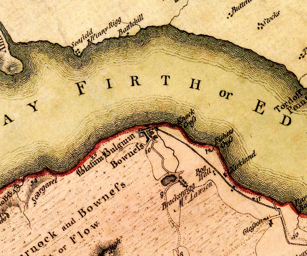 D4NY26SW.jpg 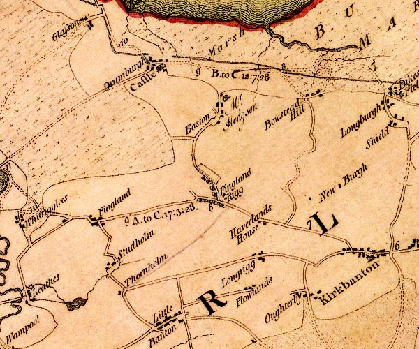 D4NY25NE.jpg "B. to C. 12:7:28" miles.furlongs.poles; Bowness to Carlisle 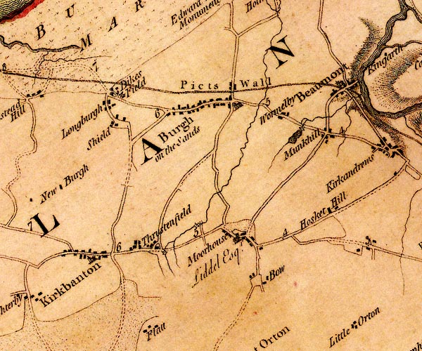 D4NY35NW.jpg 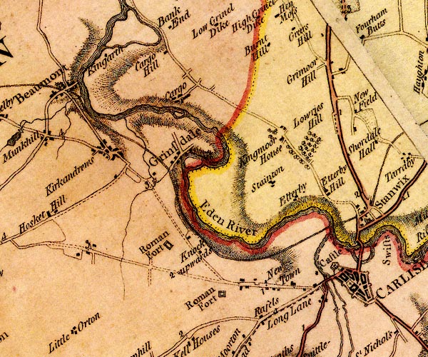 D4NY35NE.jpg from Irish Gate, over the Caldew item:- Carlisle Library : Map 2 Images © Carlisle Library |
||
|
|
|||
| evidence:- | old map:- Donald 1774 (Cmd) |
||
| source data:- | Map, hand coloured engraving, 3x2 sheets, The County of Cumberland, scale about 1
inch to 1 mile, by Thomas Donald, engraved and published by Joseph Hodskinson, 29
Arundel Street, Strand, London, 1774.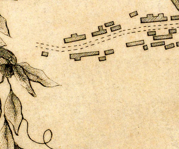 D43955J.jpg road out of towwn item:- Carlisle Library : Map 2 Image © Carlisle Library |
||
|
|
|||
| evidence:- | road book:- Cary 1798 (2nd edn 1802) |
||
| source data:- | Road book, itineraries, Cary's New Itinerary, by John Cary, 181
Strand, London, 2nd edn 1802. goto source goto source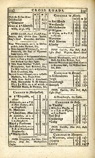 click to enlarge click to enlargeC38555.jpg page 555-556 "CARLISLE to Bowness." item:- JandMN : 228.2 Image © see bottom of page |
||
|
|
|||
| evidence:- | old map:- Laurie and Whittle 1806 |
||
| source data:- | Road map, Completion of the Roads to the Lakes, scale about 10
miles to 1 inch, by Nathaniel Coltman? 1806, published by Robert
H Laurie, 53 Fleet Street, London, 1834. click to enlarge click to enlargeLw18.jpg bold line; 'Principal Travelling Roads' item:- private collection : 18.18 Image © see bottom of page |
||
|
|
|||
| evidence:- | old painting:- |
||
| source data:- | Painting, oil painting, Baggage Waggons Approaching Carlisle, Cumberland, by Samuel
Bough, 1849.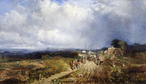 click to enlarge click to enlargePR0970.jpg The painting shows baggage waggons followed by weary troops and their families toiling along the road to Carlisle at Newtown. This road followed the canal from Port Carlisle, where steamers are likely to have brought the troops from Ireland. There is no historical significance to the troops' presence in the painting however. Bough's sister Anne modelled for the soldier's wife with child. Carlisle canal is visible on the left and the Carlisle skyline can be seen in the distance. Bough's great skill at handling weather effects can be seen in the showery sky. See the Carlisle Journal 7.7.1896 and 10.7.1896 Bough also painted a smaller oil version of this subject titled 'Convoy' which is now in the Beaverbook Art Gallery, Fredericton, New Brunswick, Canada. Interestingly, it shows the soldiers advancing towards the viewer. One of Bough's most important paintings; it marked a turning point in his career as an artist after which he began exhibiting regularly at major Scottish and English exhibitions. He painted it in the first year after his marriage in Glasgow. item:- Tullie House Museum : 1955.87 Image © Tullie House Museum |
||
|
|
|||
| evidence:- | gradient diagram:- Gall and Inglis 1890s-1900s (Roads) |
||
| source data:- | Contour Road Book of England, Northern Division, by Harry R G Inglis, published by
Gall and Inglis, 25 Paternoster Square, London and Edinburgh, 1898.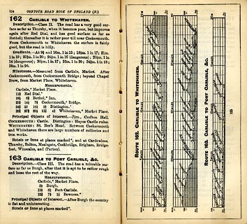 click to enlarge click to enlargeIG5162.jpg Itinerary, with gradient diagram, route 162, Carlisle to Whitehaven, and route 163, Carlisle to PortCarlisle etc, Cumberland, 1898. item:- JandMN : 763.9 Image © see bottom of page |
||
|
|
|||
| places:- | Carlisle Kirkandrews upon Eden, Beaumont Burgh by Sands Drumburgh, Bowness Glasson, Bowness Port Carlisle Bowness-on-Solway |
||
|
|
|||
Lakes Guides menu.