 Old Cumbria Gazetteer
 |
 |
|
| Salter Mine, Lamplugh | ||
| Salter Mine | ||
| Salter Hall Mine | ||
| locality:- | Salter Hall | |
| civil parish:- | Lamplugh (formerly Cumberland) | |
| county:- | Cumbria | |
| locality type:- | iron mine | |
| locality type:- | mine | |
| coordinates:- | NY06061693 | |
| 1Km square:- | NY0616 | |
| 10Km square:- | NY01 | |
| references:- | OS County Series |
|
|
|
||
| evidence:- | old map:- OS County Series (Cmd 68 6) placename:- Salter Mine |
|
| source data:- | Maps, County Series maps of Great Britain, scales 6 and 25
inches to 1 mile, published by the Ordnance Survey, Southampton,
Hampshire, from about 1863 to 1948. "Salter Mine (Iron)" |
|
|
|
||
| evidence:- | old text:- Postlethwaite 1877 (3rd edn 1913) item:- iron ore |
|
| source data:- | Book, Mines and Mining in the English Lake District, by John Postlethwaite, Keswick,
published by W H Moss and Sons, Whitehaven, Cumberland now Cumbria, 1877; published
1877-1913. goto source goto sourcepage 141:- "The deposit at Salter Hall, near Frizington, is a typical one, it is on the line of a north and south vein, having a downthrow to the east of 100 fathoms, or upwards. There are deposits of ore on both the eastern and western side of the vein, some being merely flats and others more massive. The largest as shown by the section is narrow for some distance down, it then widens considerably, the foot-wall for nearly one-third of the depth of the section is Skiddaw Slate." |
|
|
|
||
| evidence:- | old map:- Postlethwaite 1877 (3rd edn 1913) placename:- Salter Hall Mine |
|
| source data:- | Map, uncoloured engraving, Map of the Lake District Mining Field, Westmorland, Cumberland,
Lancashire, scale about 5 miles to 1 inch, by John Postlethwaite, published by W H
Moss and Sons, 13 Lowther Street, Whitehaven, Cumberland, 1877 edn 1913.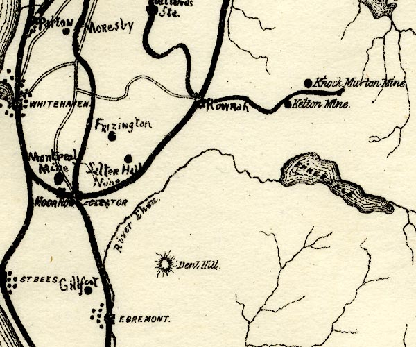 PST2NY01.jpg "Salter Hall Mine" mine symbol item:- JandMN : 162.2 Image © see bottom of page |
|
|
|
||
Lakes Guides menu.