 Old Cumbria Gazetteer
 |
 |
|
| Saltom Pit, Whitehaven | ||
| Saltom Pit | ||
| site name:- | Howgill Collieries | |
| locality:- | Arrowthwaite (?) | |
| civil parish:- | Whitehaven (formerly Cumberland) | |
| county:- | Cumbria | |
| locality type:- | coal mine | |
| locality type:- | mine | |
| coordinates:- | NX96441737 | |
| 1Km square:- | NX9617 | |
| 10Km square:- | NX91 | |
| references:- | OS County Series |
|
|
|
||
| evidence:- | old map:- OS County Series (Cmd 67 6) placename:- Saltom Pit |
|
| source data:- | Maps, County Series maps of Great Britain, scales 6 and 25
inches to 1 mile, published by the Ordnance Survey, Southampton,
Hampshire, from about 1863 to 1948. "Saltom Pit (Coal)" |
|
|
|
||
| evidence:- | possibly old map:- Donald 1774 (Cmd) placename:- Salton |
|
| source data:- | Map, hand coloured engraving, 3x2 sheets, The County of Cumberland, scale about 1
inch to 1 mile, by Thomas Donald, engraved and published by Joseph Hodskinson, 29
Arundel Street, Strand, London, 1774.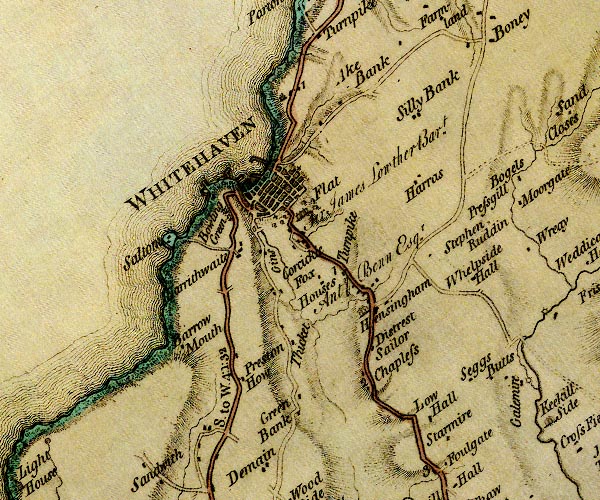 D4NX91NE.jpg "Salton" block or blocks, labelled in lowercase; a hamlet or just a house item:- Carlisle Library : Map 2 Image © Carlisle Library |
|
|
|
||
| evidence:- | old text:- Postlethwaite 1877 (3rd edn 1913) item:- coal |
|
| source data:- | Book, Mines and Mining in the English Lake District, by John Postlethwaite, Keswick,
published by W H Moss and Sons, Whitehaven, Cumberland now Cumbria, 1877; published
1877-1913. goto source goto sourcepage 152:- "As the number of pits [Whitehaven Coalfield] and the extent of the workings increased, the quantity of water in the mines also increased, and the number and power of the engines had to be increased in proportion. Some were erected at a place called Saltom, near the sea, about a mile south-west of the town. "One of these engines had two boilers of fifteen feet diameter each, and a seventy inch cylinder. The pumps attached to it were eleven and a half inches in diameter, with a six and a half feet stroke, and" goto sourcepage 154:- ""were capable of raising four hundred and five gallons of water per minute from a pit seventy-five fathoms deep." ..." |
|
|
|
||
| Finlay, Michael: 2006: Mining and Related Tokens of West Cumberland and their Issuers:
Plains Books |
||
|
|
||
Lakes Guides menu.