 Old Cumbria Gazetteer
 |
 |
|
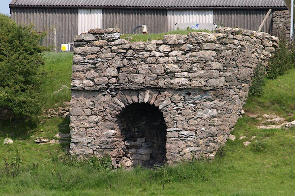
| limekiln, Lower Allithwaite (3) | ||
| Street:- | Holy Well Lane | |
| locality:- | Wyke Farm | |
| civil parish:- | Lower Allithwaite (formerly Lancashire) | |
| county:- | Cumbria | |
| locality type:- | limekiln | |
| coordinates:- | SD38877494 | |
| 1Km square:- | SD3874 | |
| 10Km square:- | SD37 | |
| references:- | Listed Buildings 2010 |
|
|
|
||
 BYS44.jpg (taken 5.7.2013) |
||
|
|
||
| evidence:- | database:- Listed Buildings 2010 |
|
| source data:- | courtesy of English Heritage "LIMEKILN APPROXIMATELY 40 METRES WEST OF WIKE FARM / / HOLY WELL LANE / LOWER ALLITHWAITE / SOUTH LAKELAND / CUMBRIA / II / 76985 / SD3887074946" |
|
| source data:- | courtesy of English Heritage "Limekiln. Probably early Cl9. Dressed stone. West elevation has segmental arched fire hole and narrow projecting course above." |
|
|
|
||
 Lakes Guides menu.