 Old Cumbria Gazetteer
 |
 |
|
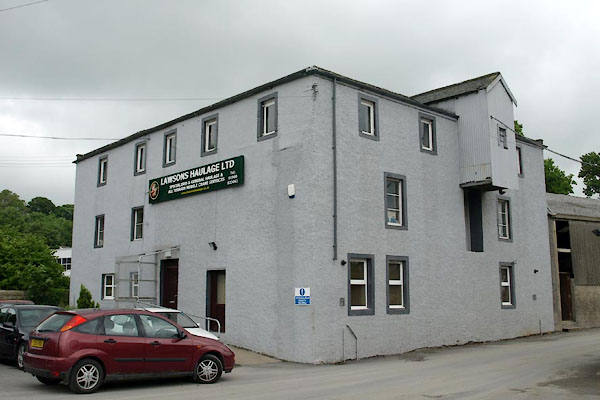
| High Gote Mill, Cockermouth | ||
| High Gote Mill | ||
| Lawsons Haulage | ||
| site name:- | Derwent, River | |
| Street:- | Gote Road | |
| locality:- | Goat | |
| locality:- | Cockermouth | |
| civil parish:- | Cockermouth (formerly Cumberland) | |
| county:- | Cumbria | |
| locality type:- | buildings | |
| locality type:- | mill (ex) | |
| locality type:- | water mill | |
| locality type:- | corn mill | |
| coordinates:- | NY11613108 | |
| 1Km square:- | NY1131 | |
| 10Km square:- | NY13 | |
| references:- | Listed Buildings 2010 |
|
|
|
||
 BYP06.jpg (taken 21.6.2013) |
||
|
|
||
| evidence:- | old map:- OS County Series (Cmd 54 4) placename:- Goat Mills |
|
| source data:- | Maps, County Series maps of Great Britain, scales 6 and 25
inches to 1 mile, published by the Ordnance Survey, Southampton,
Hampshire, from about 1863 to 1948. "Goat Mills (Corn)" |
|
|
|
||
| evidence:- | database:- Listed Buildings 2010 placename:- Cornmill at Goatmill Bridge |
|
| source data:- | courtesy of English Heritage "CORNMILL AT GOATMILL BRIDGE / / GOTE ROAD / COCKERMOUTH / ALLERDALE / CUMBRIA / II / 71680 / NY1161631086" |
|
| source data:- | courtesy of English Heritage "Probably early C19. 3 storyeys. Plain rectangular plan, stone rubble, roughcast, hipped slate roof. 5 x 4 windows, all new in old openings. Corrugated iron cabin covers pulley machinery over centre store room door on middle floor." "Goatmill House. the cottage. the barn and the Cornmill form a group." |
|
|
|
||
 Lakes Guides menu.