Old Cumbria Gazetteer
 |
 |
|
||
| included in:- |
 road, Carlisle to Edinburgh road, Carlisle to Edinburgh |
|||
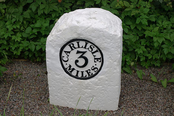
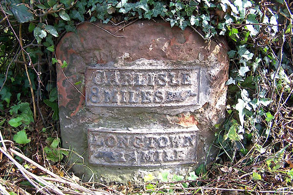
| road, Carlisle to Longtown | ||||
| Carlisle to Longtown | ||||
| Longtown to Carlisle | ||||
| A7 | ||||
| civil parish:- | Carlisle (formerly Cumberland) | |||
| civil parish:- | Rockcliffe (formerly Cumberland) | |||
| civil parish:- | Westlinton (formerly Cumberland) | |||
| civil parish:- | Arthuret (formerly Cumberland) | |||
| county:- | Cumbria | |||
| locality type:- | route | |||
| 10Km square:- | NY35 | |||
| 10Km square:- | NY36 | |||
|
|
||||
| evidence:- | old map:- Badeslade 1742 placename:- |
|||
| source data:- | Map, uncoloured engraving, A Map of Cumberland North from
London, scale about 11 miles to 1 inch, with descriptive text,
by Thomas Badeslade, London, engraved and published by William
Henry Toms, Union Court, Holborn, London, 1742. click to enlarge click to enlargeBD10.jpg "" item:- JandMN : 115 Image © see bottom of page |
|||
|
|
||||
| evidence:- | old map:- Bowen and Kitchin 1760 |
|||
| source data:- | Map, hand coloured engraving, A New Map of the Counties of
Cumberland and Westmoreland Divided into their Respective Wards,
scale about 4 miles to 1 inch, by Emanuel Bowen and Thomas
Kitchin et al, published by T Bowles, Robert Sayer, and John
Bowles, London, 1760. BO18NY47.jpg double line, dotted  BO18NY46.jpg double line, dotted  BO18NY35.jpg double line, dotted item:- Armitt Library : 2008.14.10 Image © see bottom of page |
|||
|
|
||||
| evidence:- | old map:- Donald 1774 (Cmd) |
|||
| source data:- | Map, hand coloured engraving, 3x2 sheets, The County of Cumberland, scale about 1
inch to 1 mile, by Thomas Donald, engraved and published by Joseph Hodskinson, 29
Arundel Street, Strand, London, 1774. double line, solid or dotted, with a dot or milestone and number at 1 mile intervals, tinted red; turnpike road 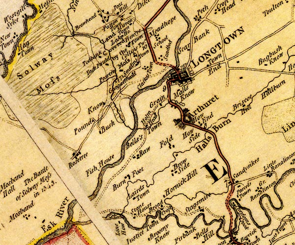 D4NY36NE.jpg 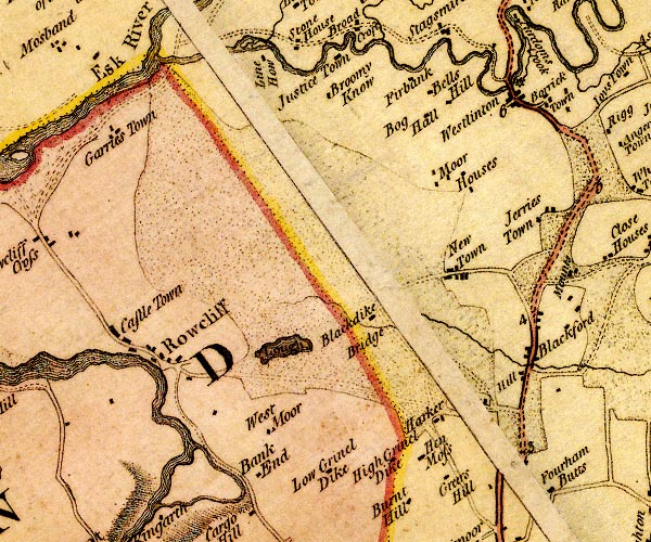 D4NY36SE.jpg 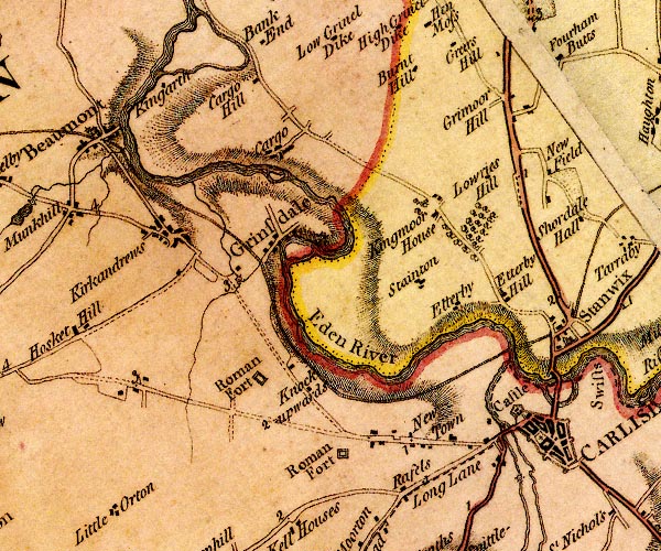 D4NY35NE.jpg from Scots Gate and over the Eden item:- Carlisle Library : Map 2 Images © Carlisle Library |
|||
|
|
||||
| evidence:- | road map:- Cary 1790 (Cmd/edn 1789) |
|||
| source data:- | Road map, hand coloured engraving, Cumberland, scale about 15
miles to 1 inch, by John Cary, 181 Strand, London, 1790, edn
1789. click to enlarge click to enlargeCY47.jpg double line, with road distances from Carlisle item:- JandMN : 419 Image © see bottom of page |
|||
|
|
||||
| evidence:- | road book:- Cary 1798 (2nd edn 1802) |
|||
| source data:- | Road book, itineraries, Cary's New Itinerary, by John Cary, 181
Strand, London, 2nd edn 1802. goto source click to enlarge click to enlargeC38267.jpg page 267-268 "Cross the Esk River; and 1¼of a Mile further, on r. a T.R. to Edin[burgh, through Longholm." goto source click to enlarge click to enlargeC38283.jpg page 283-284 "Cross the Esk River; and a ¼of a Mile beyond Longtown, on r. a T.R. to Edinburgh, thro' Longholm" goto source click to enlarge click to enlargeC38337.jpg page 337-338 "LONDON to Edinburgh, by Selkirk." part of item:- JandMN : 228.1 Image © see bottom of page |
|||
|
|
||||
| evidence:- | old map:- Cooke 1802 |
|||
| source data:- | Map, Cumberland, scale about 15.5 miles to 1 inch, by George
Cooke, 1802, bound in Gray's New Book of Roads, 1824, published
by Sherwood, Jones and Co, Paternoster Road, London, 1824. click to enlarge click to enlargeGRA1Cd.jpg double line, feathered edges; post road? item:- Hampshire Museums : FA2000.62.2 Image © see bottom of page |
|||
|
|
||||
| evidence:- | old map:- Laurie and Whittle 1806 |
|||
| source data:- | Road map, Continuation of the Roads to Glasgow and Edinburgh,
scale about 10 miles to 1 inch, by Nathaniel Coltman? 1806,
published by Robert H Laurie, 53 Fleet Street, London, 1834. click to enlarge click to enlargeLw21.jpg double line, light bold; 'Mail-Coach Roads (Direct)' item:- private collection : 18.21 Image © see bottom of page |
|||
|
|
||||
| evidence:- | old map:- Cooper 1808 |
|||
| source data:- | Map, uncoloured engraving, Cumberland, scale about 10.5 miles to
1 inch, drawn and engraved by Cooper, published by R Phillips,
Bridge Street, Blackfriars, London, 1808. click to enlarge click to enlargeCOP3.jpg double line; road item:- JandMN : 86 Image © see bottom of page |
|||
|
|
||||
| evidence:- | old map:- Wallis 1810 (Cmd) |
|||
| source data:- | Road map, hand coloured engraving, Cumberland, scale about 16
miles to 1 inch, by James Wallis, 77 Berwick Stree, Soho,
London, 1810. click to enlarge click to enlargeWL13.jpg double line, hatched; 'Mail Coach Road' item:- Dove Cottage : 2009.81.10 Image © see bottom of page |
|||
|
|
||||
| evidence:- | old text:- Gents Mag item:- Hints for a Tour in Scotland |
|||
| source data:- | Magazine, The Gentleman's Magazine or Monthly Intelligencer or
Historical Chronicle, published by Edward Cave under the
pseudonym Sylvanus Urban, and by other publishers, London,
monthly from 1731 to 1922. goto source Gentleman's Magazine 1812 part 2 p.6 "Hints for a Tour in SCOTLAND; in an Original Letter from the Hon. DAINES BARRINGTON to a Friend (probably Mr. PENNANT.)" "July 17, 1771." "DEAR SIR," "..." "From Carlisle there is a new turnpike quite to Edinburgh, with regular stages, and very decent accomodations." "I don't recollect any thing worth mentioning on this road, except that when you come to Selkirk you should inquire for Melrose Abbey.- I would advise you to lye there, as the house is a very decent one. It is not above 5 or 6 miles out of the road to Edinburgh." "... ..." |
|||
|
|
||||
| evidence:- | old map:- Hall 1820 (Cmd) |
|||
| source data:- | Map, hand coloured engraving, Cumberland, scale about 21 miles
to 1 inch, engraved by Sidney Hall, published by S Leigh, 18
Strand, London, 1820-31. click to enlarge click to enlargeHA14.jpg double line, solid; main road; Carlisle, Blockford, Longtown item:- JandMN : 91 Image © see bottom of page |
|||
|
|
||||
| evidence:- | old map:- Ford 1839 map |
|||
| source data:- | Map, uncoloured engraving, Map of the Lake District of
Cumberland, Westmoreland and Lancashire, scale about 3.5 miles
to 1 inch, published by Charles Thurnam, Carlisle, and by R
Groombridge, 5 Paternoster Row, London, 3rd edn 1843.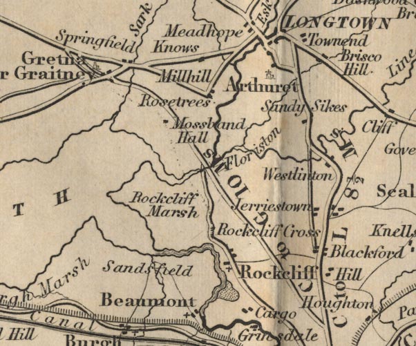 FD02NY36.jpg "C to L 8½Ms."  FD02NY35.jpg Distance from Carlisle to Longtown. item:- JandMN : 100.1 Image © see bottom of page |
|||
|
|
||||
| evidence:- | old itinerary:- Tinsley 1877 (Roads/Cum) |
|||
| source data:- | Itinerary, route 3, London to Edinburgh and Glasgow via Boroughbridge and Carlisle,
including from Bowes, Durham; through Brough, Appleby, Westmorland; then Penrith,
Carlisle, Longtown, Cumberland; and into Scotland, published by Tinsley Bros, 8 Catherine
Street, Strand, London, 1877.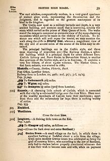 click to enlarge click to enlargeTLY139.jpg pp.36-49 in British High Roads, North and North Eastern Routes; pp.37-39. printed at p.36:- "... / ROUTE III. - LONDON to EDINBURGH and GLASGOW via / BOROUGHBRIDGE and CARLISLE (See Maps 31 to 42.) / Boroughbridge 206 (as per Route I.), Leeming 221½, Catterick 228, Greta Bridge 242½, Bowes 248½, Brough 261½, Appleby 269¾, / Penrith 283½, Carlisle 301½, Longtown 310¼, Langholm 321¾, / Hawick 349½, Selkirk 356, Middleton 379½, Edinburgh 392½. / ..." item:- private collection : 270.1 Image © see bottom of page |
|||
|
|
||||
| evidence:- | old strip map:- Tinsley 1877 (Roads/Cum) |
|||
| source data:- | Strip map, road map, part of London to Edinburgh via Boroughbridge and Carlisle, including
from before Longtown, Cumberland; and into Scotland, published by Tinsley Bros, 8
Catherine Street, Strand, London, 1877.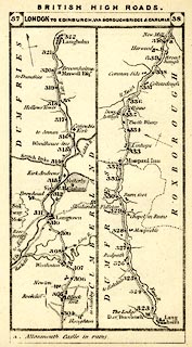 click to enlarge click to enlargeTLY1M3.jpg Map pp.37-38 in British High Roads, North and North Eastern Routes. printed at top:- "BRITISH HIGH ROADS. / 37 LONDON TO EDINBURGH, VIA BOROUGHBRIDGE &CARLISLE. 38" item:- private collection : 270.5 Image © see bottom of page |
|||
|
|
||||
| evidence:- | old text:- Harper 1907 |
|||
| source data:- | HP01p154.txt Page 154:- "..." "The geography of Gretna and the Border is, so far as roads are concerned, somewhat involved, and requires careful explanation. Up to 1830, when the wide-spreading sands of the Esk were bridged, the way for coaches and all road traffic lay circuitously through Longtown to the right of where the fork of the roads now occurs [at Kingstown]; but in that year the New Road, or the "English Road," as it commonly was called, was opened, .." HP01p155.txt Page 155:- "..." 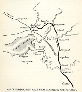 click to enlarge click to enlargeHP01M2.jpg "MAP OF OLD AND NEW ROADS FROM CARLISLE TO GRETNA GREEN." "..." item:- JandMN : 1055.27 Image © see bottom of page |
|||
|
|
||||
| evidence:- | old strip map:- CTC 1911 (Roads) |
|||
| source data:- | Page 82 of Cyclists' Touring Club British Road Book new series vol.6, edited by F
B Sandford, published by Thomas Nelson and Sons, London etc, 1911.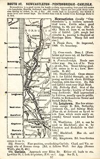 click to enlarge click to enlargeCTC282.jpg Strip road map, route 37, Newcastleton Pentonbridge Carlisle, scale roughly 5 miles to 1 inch. Together with an itinerary and gradient diagram. item:- JandMN : 491.82 Image © see bottom of page |
|||
|
|
||||
 Act of Parliament Act of Parliament |
||||
|
|
||||
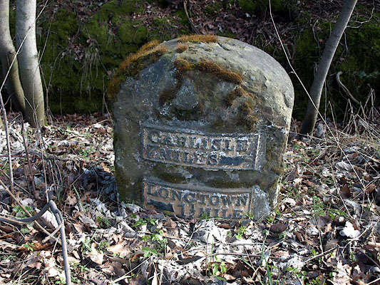
| places:- | Carlisle Blackford, Westlinton Westlinton Bridge, Westlinton Longtown |
|||
|
|
||||
| places:- |
|
|||
|
||||
|
||||
|
||||
|
||||
|
||||
|
||||
|
||||
|
||||
|
||||
Lakes Guides menu.