 Old Cumbria Gazetteer
 |
 |
|
| Silver Keld Well, Stainmore | ||
| Silver Keld Well | ||
| civil parish:- | Stainmore (formerly Westmorland) | |
| county:- | Cumbria | |
| locality type:- | spring | |
| locality type:- | well (?) | |
| coordinates:- | NY83111996 (estimate) | |
| 1Km square:- | NY8319 | |
| 10Km square:- | NY81 | |
| county:- | Durham | |
| SummaryText:- | on county boundary? | |
|
|
||
| evidence:- | old map:- OS County Series (Wmd 17) placename:- Silver Keld Well |
|
| source data:- | Maps, County Series maps of Great Britain, scales 6 and 25
inches to 1 mile, published by the Ordnance Survey, Southampton,
Hampshire, from about 1863 to 1948. OS County Series (Yrk 3) "Silver Keld Well" |
|
|
|
||
| evidence:- | old map:- Jefferys 1770 (Wmd) placename:- Silver Kale Well |
|
| source data:- | Map, 4 sheets, The County of Westmoreland, scale 1 inch to 1
mile, surveyed 1768, and engraved and published by Thomas
Jefferys, London, 1770.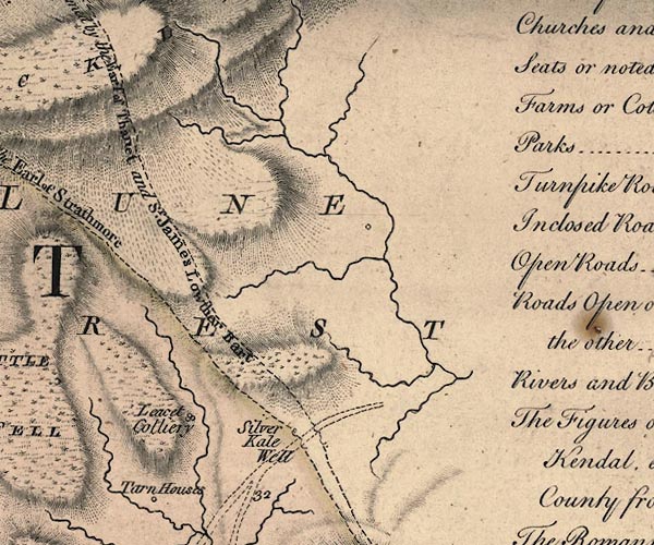 J5NY82SW.jpg "Silver Kale Well" circle; spring or well item:- National Library of Scotland : EME.s.47 Image © National Library of Scotland |
|
|
|
||
 Lakes Guides menu.