 Drayton 1612/1622

|

|
|

|
back to object record | |
| MAP FEATURES | ||
|
Even considered as a sketch map the plot is full of errors;
it is hardly fair to treat it as a map. Tints for features
are noted; the naiads, dryads, and other figures are tinted
'proper', natural colours.
|
||
|
|
||
| title |
The map has no title but is boldly labelled with two
county names:-
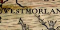
WESTMORLANDE CUMBERLANDE There is a plate number upper right:- 161 |
|
|
|
||
|
orientation
up is N |
The map is printed with North at the top of the sheet;
roughly.
|
|
|
|
||
| scale |
There is no indicator of scale. It is possible to
estimate a scale for the map, roughly about:-
1 to 250000 4 or 5 miles to 1 inch |
|
|
|
||
|
sea area
sea moire effect |
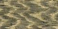
The sea is engraved with a moire effect pattern, tinted pale blue? |
|
|
|
||
|
coast line
coast shaded foreshore |
The coast line is emphasized by shading, tinted blue. Foreshore sands might be indicated by a dotted area. |
|
|
|
||
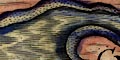
| rivers |
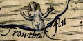
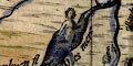
Rivers are drawn by a wiggly double line, perhaps with stream lines, tapering to a single line upstream, tinted blue. The rivers mostly have a resident naiad either standing thigh deep in the stream, or standing at the head of the stream pouring out its waters from a pot. Many of the streams are named, eg:- 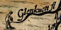
Glenkuen fl [Glencoyne] Loder flu [Lowther] |
|
|
|
||
| lakes |
Lakes are mostly drawn by an outline, usually looking like a broadening of the river. The lake has shore shading, and is tinted blue. A lake might be labelled,:- Darwen fl [with Darwen I.] Devocke flu [drawn as a river] Thurle mere [E of Helvellyn, W of Borrowdale] Ulles mere Or might be, unreliably, recognized, eg:- Bassenthwaite Lake Buttermere Crummock Water Ennerdale Water [outline only] Loweswater Windermere lake Loweswater, Crummock Water and Buttermere and incorrectly connected. Some lakes have a naiad standing in the water. |
|
|
|
||
|
relief
hillocks |
A very few hills are noticed, shown by a large hillock,
tinted brown, with a gentleman sitting on top with hat and
cloak, and perhaps a staff. Each is labelled, eg:-
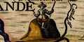
Skiddow hill Wenrose hill [perhaps Wrynose Fell] A number of valleys are noticed, marked by lady reclining or sitting, dressed in gown and hat, labelled, eg:- 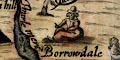
Borrowdale Wasdale |
|
|
|
||
| forests |
Some forests are noticed, marked by a large tree, tinted
green, with a dryad in gown and hat, carrying a bow and
arrows or a spear, usually labelled, eg:-
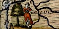
Whinfeeld for: |
|
|
|
||
| county |
There are no county boundaries, but two county areas are
labelled, eg:-
WESTMORLANDE |
|
|
|
||
| settlements |
A few towns are marked by a lady dressed in a gown with a
town symbol, buildings tinted red, as a headdress, labelled,
eg:-
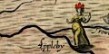
Appleby CARLELL |
|
|
|
||
| miscellaneous | ||
|
|
||
|
antiquities
stone circles stone alignments |
Long Meg and Her Daughters is marked by a ring of 18
standing stones, labelled:-
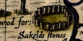
Sakelds stones Karl Lofts, the alignment at Shap, is marked by a double row of standing stones, labelled:- Loder ston's [Lowther stones] |
|
|
|
||
|
wells
springs |
An unidentified well or spring is marked a circular stone
well head, with a naiad sitting on the side, labelled:-
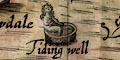
Tiding well This is north of Windermere, but bearing in mind the general inaccuracy of the plot, don't take this as a firm location. |
|
Lakes Guides menu.