 Cumberlande and Westmorlande

|

|
|
|
map type:- Drayton 1612/1622 |
|
|
|
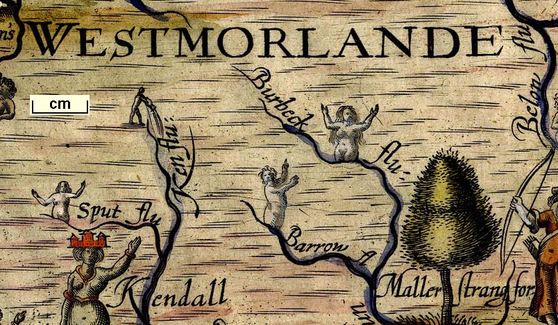
Map, Cumberlande and Westmorlande, by Michael Drayton in
part 2 of Polyolbion, probably engraved by William Hole;
published by John Marriott, John Grismand, and Thomas Dewe,
London, 1622.
Published in 'A Chorographicall Description of ... Great Britain ... By Michael Drayton Esquire ...: London printed for John Marriott, John Grismand, and Thomas Dewe. 1622.', 'The Second Part, or a continuance of Poly-Olbion from the eighteenth Song ... London, Printed by Augustine Matthews for John Marriott, John Grismand, and Thomas Dewe. 1622.' The map illustrates the Second Song of Polyolbion, it shows little more than allegorical figures, rivers, mountains and forests, all that is labelled is 'WESTMORLANDE' and 'CUMBERLANDE'; the map is plain on the reverse; the book size is 7 5/8 x 11 1/2 ins. |
||
|
Included in A Chorographicall Description of ... Great
Britain, better known as Poly Olbion.
|
||
| map feature:- | up is N & sea moire effect & coast shaded & rivers & lakes & forests & relief & hillocks & county | |
| inscription:- |
printed upper right
161 |
|
| wxh, sheet:- | 33.5x27.5cm | |
| wxh, map:- | 309x242mm | |
| scale:- | 1 to 250000 ? (crude estimate) | |
| references:- |
Drayton, Michael: 1622: Poly-Olbion: John Marriot, John
Grismand, Thomas Dewe (London) Drayton, Michael: 1890 (reprint from 1622 edition): Poly-Olbion: Spencer Society Hebel, J W (ed): 1933=1941: Works of Michael Drayton, The: (Oxford) |
|
| sources:- |
Chubb 1927 (XXXV) Kendal Library Maps JandMN Collection |
|
| items seen (illustrated items in bold):- | ||

|
JandMN (168) -- map -- Cumberlande and Westmorlande | |