 Europe Table I

|

|
|
|
map type:- Ptolemy 1578 |
|
|
|
Map, British Isles from Ptolemy's data, Europe Table I,
by Gerard Mercator, 1578.
The geographical data, a world gazetteer 'Geographia', was compiled by Claudius Ptolemy and later used by various cartographers to draw maps, often referred to as Ptolemy maps. Gerhard Mercator, much of whose life was concerned with revising Ptolemy's data, produced this map in 1578. Published in further editions 1584, 1605, 1618-19; the plate was altered and published in a 2nd state 1695 to 1704; and in a 3rd state 1730. Places of interest to Westmorland, Cumberland, etc are Morecambe Bay and the Eden estuary. |
||
|
(example map)
|
||
| map feature:- | up is N & lat and long scales & sea pecked & coast shaded & rivers & tribal areas & settlements | |
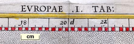
| inscription:- |
printed top
EUROPAE .I. TAB : |
|
| wxh:- | 33.5x40.5cm | |
| references:- |
Mercator, Gerhard: 1578: Tabulae Geographicae Cl. Ptolemaei
ad mentem autoris restitutae et emendatae Per Gerardum
Mercatorem: (Cologne, Germany) |
|
| sources:- |
private collection |
|
| items seen (illustrated items in bold):- | ||

|
private collection (13) -- map -- Prima Europe tabula -- Europe Map 1 | |