 Morden 1695 (Wmd) NY72


|

|
|
|
gazetteer links places may or may not be labelled on the map |
||

|
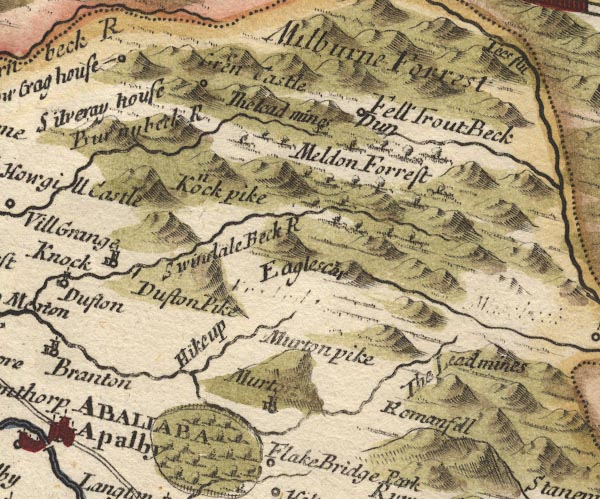
-- Dufton Fell -- "Meldon Forrest" |
|
|
|
-- Dufton Pike -- "Dufton Pike" |
|
|
|
-- Great Dun Fell -- "Fell / Dun" |
|
|
|
-- Green Castle -- "Green Castle" |
|
|
|
-- High Cup Gill -- "Hikeup" |
|
|
|
-- High Cupgill Beck |
|
|
|
-- Knock Ore Gill -- "Burnybeck R" |
|
|
|
-- Knock Pike -- "Knock pike" |
|
|
|
-- Knock -- "Knock" |
|
|
|
-- Little Dun Fell -- "Fell / Dun" |
|
|
|
-- Low Crag House (?) -- "Low Crag house" |
|
|
|
-- Milburn Beck -- "Burnybeck R" |
|
|
|
-- Milburn Forest -- "Milburne Forrest" |
|
|
|
-- -- "The Lead mines" |
|
|
|
-- -- "The Lead mines" |
|
|
|
-- Murton -- "Murton" |
|
|
|
-- Murton Lead Mines -- "The Lead mines" |
|
|
|
-- Murton Pike -- "Murton pike" |
|
|
|
-- Nichol Chair -- "Eaglescar" |
|
|
|
-- Roman Fell -- "Romanfell" -- "Rumary
Fell" |
|
|
|
-- Silveray (?) -- "Silveray house" |
|
|
|
-- Swindale Beck -- "Swindale Beck R" |
|
|
|
-- Trout Beck -- "Trout Beck" |
|
|
civil parishes The area roughly includes parts of parishes:- Warcop Dufton Murton Musgrave Long Marton |
||
|
|
||
|
|
Lakes Guides menu. | |