 Ogilby 1675, road maps
 | |
|
Road book, Britannia, a series of 100 road strip
maps, scale about 1 inch to 1 mile, including 4 plates
with routes in Westmorland and Cumberland now Cumbria, by
John Ogilby, London, 1675. Plates with roads in Cumbria are:- plate 38 - the continuation of the Road from London to Carlisle includes from Garstang through Lancaster, Boulton, and Carnforth, Lancashire; then Burton, Kendal, Shap, Westmorland, and Penrith to Carlisle, Cumberland. 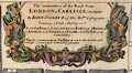 plate 96 - the Road from Kendal to Cockermouth includes from Kendal through Stanley ie Staveley, Ambleside, Westmorland; then Keswick to Cockermouth, Cumberland; AND the Road from Egremond to Carlisle from Egremond ie Egremont through Cockermouth to Carlisle, Cumberland.  plate 62 - the Road from Carlisle ... to Barwick ... includes from Carlisle; through Jedbrough ie Jedburgh, Kelso, Scotland; to Barwick ie Berwick, Northumberland. 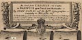 plate 86 - the Road from Tinmouth ... to Carlisle ... includes from Tinmouth ie Tynemouth, through Newcastle, Corbridg, Hexham, and Haltwesell ie Haltwhistle, Northumberland; then via Corbey to Carlisle, Cumberland. 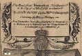 General map of England and Wales which includes Westmorland, Cumberland, etc. Published in "Britannia, Volume the First: or, an Illustration of the Kingdom of England and Dominion of Wales: By a Geographical and Historical Description of the Principal Roads thereof. Actually Admeasured and Delineated in a Century of Whole-sheet Copper Sculps. Accomodated With the Ichnography of the several Cities and Capital Towns; and Compleated By an Accurate Account of the more Remarkable Passages of Antiquity, Together with a Novel Discourse on the Present State. By John Ogilby Esq; His Majesty's Cosmographer, and Master of His Majesty's Revels in the Kingdom of Ireland. London, Printed by the Author at his House in White-Fryers. MDCLXXV." 1675. The first edition has a map of England showing the routes, there is an illustrated title page, a dedication to Charles II whose coat of arms is on each map, preface, list of post roads etc; each route is described in text pages; the atlas size is 11 x 17 ins; the maps are strip maps of roads at a scale 1 inch to 1 mile, accurately measured. Published in a ?second edition in 1675, with plate numbers. Published again in 1675 in "Itinerarium Angliae: or, A Book of Roads, Wherein are Contain'd The Principal Road Ways of His Majesty's Kingdom of England and Dominion of Wales: Actuall Admeasured and Delineated in a Century of Whole-sheet Copper Sculps, and Illustrated with the Ichnography of the several Cities and Capital Towns. By John Ogilby Esq ... London, Printed by the Author at his House in White-Fryers. M.D.C.LXXV." 1675. The 3rd edition is a reprint without the text pages, with different general text. Published in a reprint 1698, "Britannia: or, the Kingdom of England and Dominion of Wales, actually survey'd with a Geographical and Historical Description of the Principal Roads ... By John Ogilby, Esq., Cosmographer to Charles the Second. London: Printed for Abel Swall at the Unicorn in Pater-noster-row, and Robert Morden, at the Atlas in Cornhill, MDCXCVIII." 1698. The 1698 reprint has the original plates with reduced text. There are series of closely derived versions of these maps published in the early 18th century, by Gardner, Senex, Bowen, etc etc. |
|

|
Plate 38; part of London to Carlisle. |
|
|
Plate 96; Kendal to Cockermouth. |
|
|
Plate 96; Egremont to Carlisle. |
|
|
Plate 62; Carlisle to Barwick. |
|
|
Plate 86; Tinmouth to Carlisle. |
|
|
Lakes Guides menu. |