|
 |
|
|
|
|
|
| coordinates:- |
NY34201513 |
|
| evidence:- |
outline view:- Otley 1823 (4th edn 1830)
|
| source data:- |
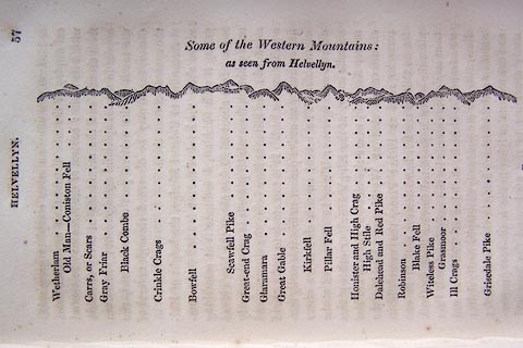
Print, engraving, outline view, Some of the Western Mountains as seen from Helvellyn,
published by Jonathan Otley, Keswick, Cumberland et al, 1830.
 click to enlarge click to enlarge
O75E02.jpg
p.57 in A Concise Description of the English Lakes, by Jonathan Otley, 4th edition,
1830.
printed at top:- "Some of the Western Mountains: / as seen from Helvellyn."
printed at bottom:- "Wetherlam / Old Man - Coniston Fell / Carrs, or Scars / Gray Friar / Black Combe /
Crinkle Crags / Bowfell / Scawfell Pike / Great-end Crag / Glaramara / Great Gable
/ Kirkfell / Pillar Fell / Honister and High Crag / High Stile / Dalehead and Red
Pike / Robinson / Blake Fell / Witeless Pike / Grasmoor / Ill Crags / Grisedale Pike"
item:- Armitt Library : A1175.3
Image © see bottom of page
|
|
|
| evidence:- |
outline view:- Otley 1823 (5th edn 1834)
|
| source data:- |
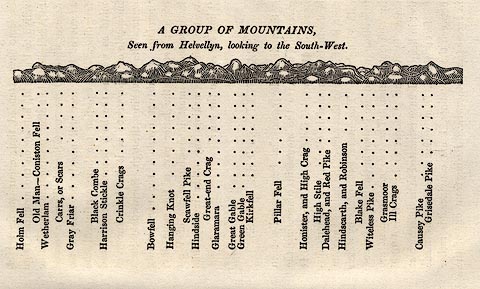
Print, woodcut outline view, A Group of Mountains, seen from Helvellyn, by Jonathan
Otley, Keswick, Cumberland now Cumbria, 1834.
 click to enlarge click to enlarge
OT2E09.jpg
Printed on p.63 of A Concise Description of the English Lakes, by Jonathan Otley,
5th edition, 1834.
printed at top:- "A GROUP OF MOUNTAINS, / Seen from Helvellyn, looking to the South-West."
printed at bottom:- "Holm Fell / Old Man - Coniston Fell / Wetherlam / Carrs, or Scars / Gray Friar / Black
Combe / Harrison Stickle / Crinkle Crags / Bowfell / Hanging Knot / Scawfell Pike
/ Hindside / Great-end Crag / Glaramara / Great gable / Green Gable / Kirkfell / Pillar
Fell / Honister, and High Crag / High Stile / Dalehead, and Red Pike / Hindscarth,
and Robinson / Blake Fell / Witeless Pike / Grasmoor / Ill Crags / Causey Pike / Grisedale
Pike"
item:- JandMN : 48.10
Image © see bottom of page
|
|
|
| evidence:- |
old map:- Otley 1818
placename:- Helvellyn
|
| source data:- |
Map, uncoloured engraving, The District of the Lakes,
Cumberland, Westmorland, and Lancashire, scale about 4 miles to
1 inch, by Jonathan Otley, 1818, engraved by J and G Menzies,
Edinburgh, Scotland, published by Jonathan Otley, Keswick,
Cumberland, et al, 1833.
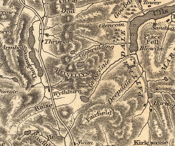
OT02NY31.jpg
"HELVELLYN"
item:- JandMN : 48.1
Image © see bottom of page
|
|
|
| evidence:- |
descriptive text:- Otley 1823 (5th edn 1834)
item:- latitude; longitude; lat and long
|
| source data:- |
Print, woodcut outline view, A Group of Mountains, seen from
Helvellyn, by Jonathan Otley, Keswick, Cumberland, 1830.
 goto source goto source
Page 58:- "HELVELLYN"
"Affords a more complete geographical display of the lake district than any other point
within its limits: several of the lakes may be viewed from thence, and the mountains
in every direction appear in a most splendid arrangement; while from the south to
the western part of the horizon, the distant ocean may be discerned through several
of the spaces between them."
"..."
goto source
Page 60:- "..."
"The ground towards the summit forms a kind of moss-clad plain, sloping gently to the
west, and terminated on the east by a series of rocky precipices; and here the prospect
on every side is grand beyond conception. Considerable portions of the lakes of Ullswater,
Windermere, Coniston, and Esthwaite, with several of the mountain tarns, are to be
seen. Red Tarn is seated so deeply below the eye, that, compared with its gigantic
accompaniments, it would scarcely be estimated at more than half its actual dimensions.
To the right and left of Red Tarn, the two narrow ridges called Striding Edge, and
Swirrel Edge, are stretched out in the direction of the lamina of the slaty rock,
of which this part of the mountain is composed; other parts being of chert or hornstone,
resting upon porphyritic greenstone. Beyond Swirrel Edge lies Keppel-cove Tarn; and
at the termination of the ridge rises the peak of Catsty-cam, modernized into Catchedecam,
or Catchety-cam. Angle-tarn, and the frothy stream from"
goto source
Page 61:- "Hays Water, may be seen among the hills beyond Patterdale: and more remote, the estuaries
of the Kent and Leven, uniting in the wide bay of Morecambe, and extending to the
distant ocean. Chapel Isle is an object in the Ulverston channel; and a small triangular
piece of water, near the middle of Windermere, serves as a direction to the town and
Castle of Lancaster, which are sometimes visible from hence. The sea, circumscribing
the western half of the Lake district, from Lancaster sands to the Solway Frith, is
here and there visible between the peaks of the distant mountains; each portion in
succession reflecting the sun's rays to the eye of the spectator, as the luminary
descends towards the western horizon."
"On the banks of Ullswater, Hallsteads, the beautiful summer retreat of John Marshall,
Esq. occupies a prominent station. From the foot of the lake the vale of Eamont leads
towards Brougham-Hall and the ruins of the ancient Castle near it. The cultivated
country about Penrith is bounded by a chain of mountains, topped by the lofty Crossfell;
to the right of which, are high grounds separating Westmorland from Durham and Yorkshire;
and further still to the right, the crowned head of Ingleborough stands conspicuous.
Black Combe - in the distance beyond Wrynose - fills up the space between the fells
of Coniston and Langdale; Crinkle Crags and Bowfell are exceeded in altitude by the
Pikes on Scawfell; and on the opposite side of Sty-head, the Gable rears his head
to a considerable"
goto source
Page 62:- "elevation. The Isle of Man appears to be raised up to the top of Kirkfell, the distance
of more than forty miles between them being overlooked."
"The Pillar of Ennerdale holds a respectable station; and the mountain beyond Buttermere,
with its three protuberances, High Crag, High Stile, and Red Pike, rises behind Honister
Crag and the Dalehead of Newlands. Grasmoor and Grisedale Pike look well up among
their neighbours, while Skiddaw and Saddleback abate nothing of their importance on
being viewed from this elevation. The mountains of Scotland, seen beyond the Solway
Frith, fill up the distance; and nearer to our station, High Street, Ill-bell, Fairfield,
and many other neighbouring eminences, ought not to be overlooked. Place Fell, and
other mountains of Martindale, rise boldly beyond Ullswater; but those towards the
foot of Hawes Water present less variety of outline."
"By travelling along the ridge, to a little distance each way, a variety of prospects
may be enjoyed; which those who return directly leave unseen. On proceeding a little
northward, one of the islands on Windermere comes in view; and at the lower or northern
man, the lakes of Thirlmere and Bassenthwaite: by deviating a little to the westward
we see a small portion of Grasmere; and by following the edge of the precipice southward,
better views of Patterdale present themselves;"
goto source
Page 63:-
click to enlarge
OT2E09.jpg
"A GROUP OF MOUNTAINS, Seen from Helvellyn, looking to the South-West."
"Holm Fell / Old Man - Coniston Fell / Wetherlam / Carrs, or Scars / Gray Friar / Black
Combe / Harrison Stickle / Crinkle Crags / Bowfell / Hanging Knot / Scawfell Pike
/ Hindside / Great-end Crag / Glaramara / Great Gable / Green Gable / Kirkfell / Pillar
Fell / Honister, and High Crag / High Stile / Dalehead, and Red Pike / Hindscarth,
and Robinson / Blake Fell / Witeless Pike / Grasmoor / Ill Crags / Causey Pike / Grisedale
Pike"
goto source
Page 79:- "STATION III.- HELVELLYN."
"Latitude 54° 31′ 43″ N. Longitude 3° 0′ 24″W. Height 3070 feet."
|
|
|
|
|
BEARINGS |
Distances
in miles |
Height
in feet |
|
|
|
|
| Cheviot |
28° NE |
75 |
2658 |
| Cross Fell |
60 NE |
24 |
2901 |
| Stainmoor |
88 SE |
34 |
|
| Ingleborough |
45 SE |
36 |
2361 |
| Bidston Lighthouse, Cheshire |
1 SW |
79 |
|
| Garreg Mountain, Flintshire |
8 SW |
87 |
835 |
| Old Man, Coniston |
21 SW |
12 |
2577 |
| Snowdon |
24 SW |
112 |
3571 |
| Snea Fell |
74 SW |
61 |
2004 |
| Crif Fell |
40 NW |
38 |
1831 |
item:- JandMN : 48.10
Image © see bottom of page
|
|
|
| evidence:- |
outline view:- Otley 1823 (8th edn 1849)
|
| source data:- |
Print, engraving, outline view of mountains, A Group of Mountains seen from Helvellyn,
looking towards the South West, drawn by Mr Binns, Halifax, engraved by Mr Jewitt,
Headington, Oxfordshire, published by Jonathan Otley, Keswick, Cumberland et al, 1849.
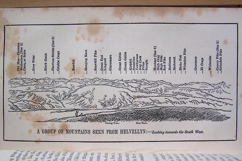 click to enlarge click to enlarge
O80E17.jpg
Opposite p.50 of A Descriptive Guide of the English Lakes, by Jonathan Otley, 8th
edition, 1849.
printed at bottom:- "A GROUP OF MOUNTAINS SEEN FROM HELVELLYN: - / Looking towards the South West."
printed at top:- "Old Man - Coniston / Wetherlam (line 2) / Carrs, or Scars / Grey Friar / Black Comb
/ Harrison Stickle (line 2) / Crickle Crags / Bowfell / Hanging Knot / Scawfell Pike
/ Great End / Lingmel / Glaramara / Great Gable / Green Gable / Kirkfell / Seatallan
/ Yewbarrow / Hay Cock / Pillar / Steeple / Honister (line 2) / High Crag / High Stile
/ Red Pike / Robinson / Melbreak / Blake Fell / Whiteless Pike / Grasmoor / Ill Crags
/ Whiteside / Causey Pike (line 2) / Grisedale Pike"
Looking WSW; 90 degree view, SSW to WNW
item:- Armitt Library : A1180.18
Image © see bottom of page
|
|
|