 Old Cumbria Gazetteer
 |
 |
|
| Place Fell, Patterdale | ||
| Place Fell | ||
| St Blasius Fell | ||
| civil parish:- | Patterdale (formerly Westmorland) | |
| civil parish:- | Martindale (formerly Westmorland) | |
| county:- | Cumbria | |
| locality type:- | hill | |
| coordinates:- | NY40561696 (etc) | |
| 1Km square:- | NY4016 | |
| 10Km square:- | NY41 | |
| altitude:- | 2156 feet | |
| altitude:- | 657m | |
|
|
||
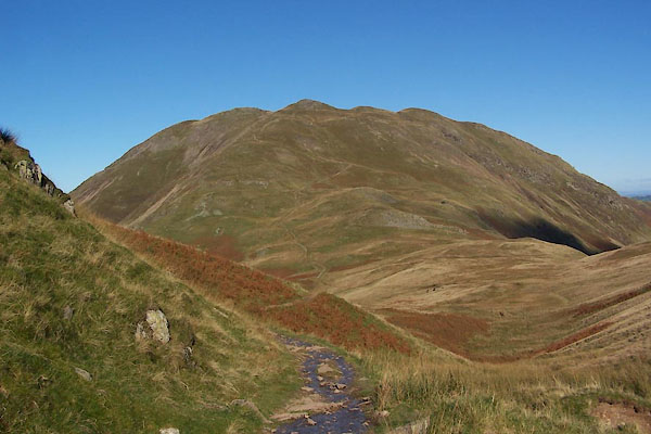 BTS61.jpg (taken 20.10.2010) 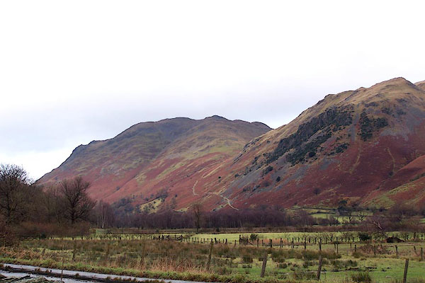 BLK69.jpg From Cow Bridge, Hartsop. (taken 5.12.2005) |
||
|
|
||
| evidence:- | old map:- OS County Series (Wmd 12 11) placename:- Place Fell |
|
| source data:- | Maps, County Series maps of Great Britain, scales 6 and 25
inches to 1 mile, published by the Ordnance Survey, Southampton,
Hampshire, from about 1863 to 1948. |
|
|
|
||
| evidence:- | old map:- Jefferys 1770 (Wmd) placename:- Place Fell |
|
| source data:- | Map, 4 sheets, The County of Westmoreland, scale 1 inch to 1
mile, surveyed 1768, and engraved and published by Thomas
Jefferys, London, 1770.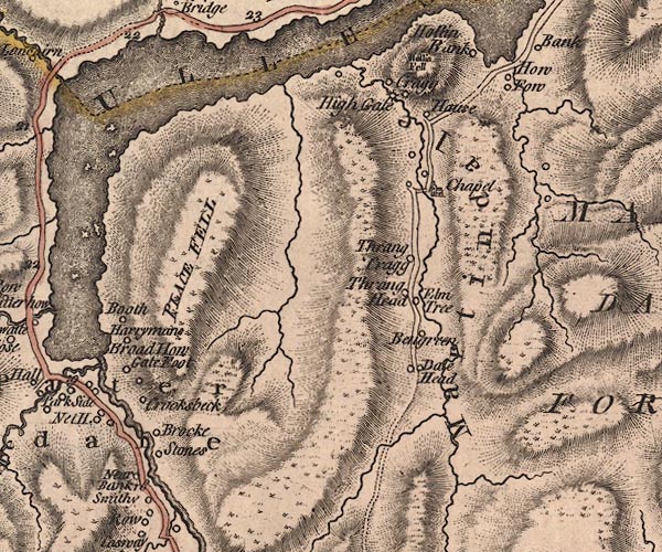 J5NY41NW.jpg "PLACE FELL" hill hachuring; hill or mountain item:- National Library of Scotland : EME.s.47 Image © National Library of Scotland |
|
|
|
||
| evidence:- | old map:- Donald 1774 (Cmd) placename:- Place Fell |
|
| source data:- | Map, hand coloured engraving, 3x2 sheets, The County of Cumberland, scale about 1
inch to 1 mile, by Thomas Donald, engraved and published by Joseph Hodskinson, 29
Arundel Street, Strand, London, 1774.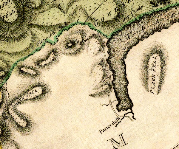 D4NY31NE.jpg "PLACE FELL" hill hachuring; a hill or mountain item:- Carlisle Library : Map 2 Image © Carlisle Library |
|
|
|
||
| evidence:- | descriptive text:- West 1778 (11th edn 1821) |
|
| source data:- | Guide book, A Guide to the Lakes, by Thomas West, published by
William Pennington, Kendal, Cumbria once Westmorland, and in
London, 1778 to 1821. goto source goto sourcePage 153:- "[Mr Gray] '... [Ullswater from Dunmallet] the mountains, which rise very rude and awful, with their broken tops, on each hand. Directly in front, at better than three miles distance, Place-fell, one of the bravest among them, pushes its bold breast into the midst of the lake, and forces it to alter its course, forming first a large bay to the left, and then bending to the right. ...'" goto sourceAddendum; Mr Gray's Journal, 1769 Page 201:- "Oct. 1. A grey autumnal day, the air perfectly calm, and mild, went to see Ulls-water, ... From hence [Dunmallard Hill] saw the lake open directly at my feet, ... mountains which rise very rude and awful with their broken tops on each hand. Directly in front, at better than three miles distance, Place-fell, one of the bravest among them, pushes its bold broad breast into the midst of the lake, and forces it to alter its course, forming first a large bay to the left, and then bending to the right. ..." |
|
|
|
||
| evidence:- | old map:- Crosthwaite 1783-94 (Ull) placename:- Place Fell |
|
| source data:- | Map, uncoloured engraving, Accurate Map of the Beautiful Lake of
Ullswater, scale about 3 inches to 1 mile, by Peter Crosthwaite,
Keswick, Cumberland, 1783, version published 1800.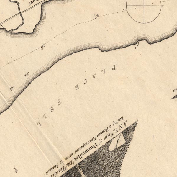 CT5NY41E.jpg 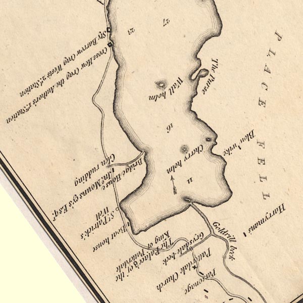 CT5NY31Y.jpg "PLACE FELL" item:- Armitt Library : 1959.191.7 Image © see bottom of page |
|
|
|
||
| evidence:- | old map:- West 1784 map placename:- Place Fell |
|
| source data:- | Map, hand coloured engraving, A Map of the Lakes in Cumberland,
Westmorland and Lancashire, scale about 3.5 miles to 1 inch,
engraved by Paas, 53 Holborn, London, about 1784.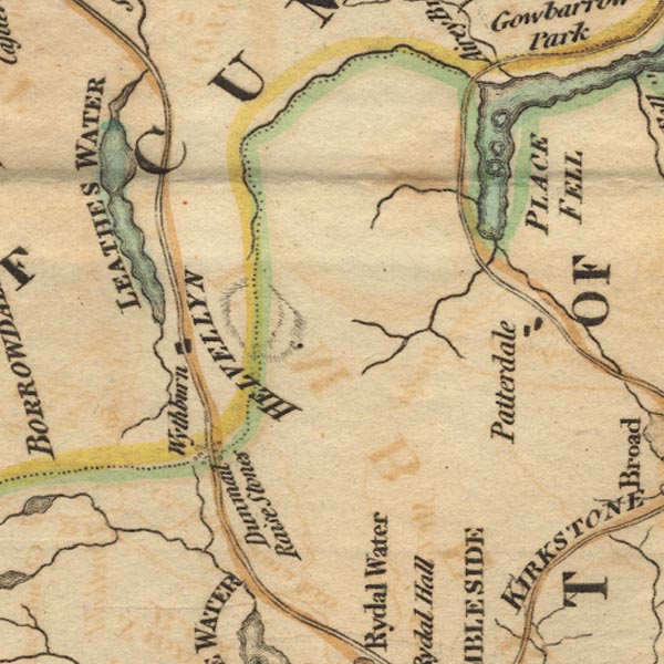 Ws02NY31.jpg "PLACE FELL" item:- Armitt Library : A1221.1 Image © see bottom of page |
|
|
|
||
| evidence:- | old text:- Gilpin 1786 placename:- Martindale Fell placename:- Place Fell |
|
| source data:- | Book, Observations, Relative Chiefly to Picturesque Beauty, Made
in the Year 1772, on Several Parts of England, Particularly the
Mountains, and Lakes of Cumberland Westmoreland, by Rev William
Gilpin, 1772-74; published 1786-1808. goto source vol.2 p.55 "... a mountain, called Martindale-fell, or Place-fell: the southern boundary of the lake. This promontory uniting with the mountain, lets it easily down into the water, as by a step. An hesitation, if I may so call it, of this kind, eases greatly the heaviness of a line. In a distance, it is of less consequence: but in all the nearer grounds, it is necessary. ..." "Martindale-fell is entirely unplanted; but it's line, and surface are both well varied. Numberless breaks (little vallies, and knolls) give it a lightness, without injuring it's simplicity." "..." goto sourcevol.2 p.56 "[near] the edge of which [lake] lies the village of Patterdale." "We took this view at a point, which had just so much elevation, as to give variety to the lines of the lake. As we descended to the water, the view was still grand, and beautiful, but had lost some of it's more picturesque beauties: it had lost the fore-ground: it had lost the sweeping line round the mountain on the left: and it had lost the recess between the two woody promontories on the right. The whole margin of the lake was nearly reduced to one straight line.- The beauty of a view, especially in lake-scenery, we have before observed *, depends greatly on the nice position of it's point." "[2.56.*] See page 96. Vol. 1." |
|
|
|
||
| evidence:- | old text:- Clarke 1787 placename:- Pless Fell |
|
| source data:- | Guide book, A Survey of the Lakes of Cumberland, Westmorland,
and Lancashire, written and published by James Clarke, Penrith,
Cumberland, and in London etc, 1787; published 1787-93. goto source Page 32:- "... The whole Dale [Patterdale] consists at present of five small manors; Hartsop, the property of the Earl of Lonsdale; Deep-Dale, of the Duke of Norfolk; Griesdale and Pless-Fell, of William Hassel, Esq; of Dalemain; and Glenridding, of John Mounsey, Esquire." goto sourcePage 34:- "... failing (sic) under Pless-Fell take a view into Martindale. The first thing worth notice is the wall, almost opposite to Householm island [Norfolk Island], where Pless-Fell changes its name to Birk-Fell, (which it preserves as far as Sandwich Fields,) and where Martindale begins. ..." |
|
|
|
||
| evidence:- | old print:- Clarke 1787 placename:- Pless Fell |
|
| source data:- | Topograph, the view from Penrith Beacon, Cumberland, by James
Clarke, published by James Clarke, London, 1787. click to enlarge click to enlargeCL18.jpg "Pless Fell" item:- Armitt Library : A6615.12 Image © see bottom of page |
|
|
|
||
| evidence:- | old map:- Clarke 1787 map (Ullswater) placename:- Place Fell |
|
| source data:- | Map, A Map of the Lake Ullswater and its Environs, scale about
6.5 ins to 1 mile, by James Clarke, engraved by S J Neele, 352
Strand, published by James Clarke, Penrith, Cumberland and in
London etc, 1787.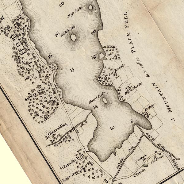 CL4NY31Y.jpg "A MOUNTAIN here called PLACE FELL" item:- private collection : 10.4 Image © see bottom of page |
|
|
|
||
| evidence:- | old map:- Cary 1789 (edn 1805) placename:- Place Fell |
|
| source data:- | Map, uncoloured engraving, Westmoreland, scale about 2.5 miles
to 1 inch, by John Cary, London, 1789; edition 1805.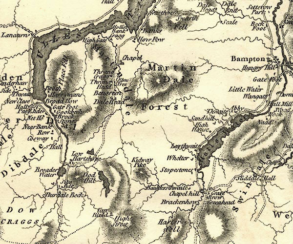 CY24NY41.jpg "Place Fell" hill hachuring item:- JandMN : 129 Image © see bottom of page |
|
|
|
||
| evidence:- | old print:- Green 1814 (plate 48) item:- cattle |
|
| source data:- | Print, uncoloured soft ground etching, Brother Water, Patterdale, Westmorland, by
William Green, Ambleside, Westmorland, 1814.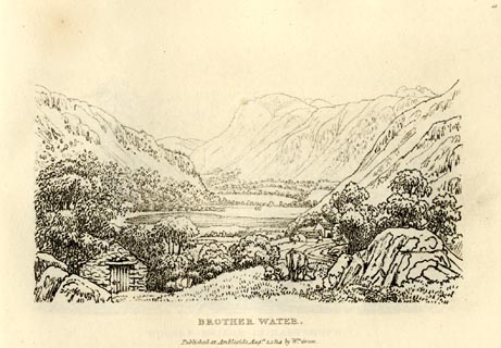 click to enlarge click to enlargeGN0948.jpg Plate 48 in Sixty Small Prints. printed at top right:- "48" printed at bottom:- "BROTHER WATER. / Published at Ambleside Augst. 1, 1814, by Wm. Green." item:- Armitt Library : A6656.48 Image © see bottom of page |
|
|
|
||
| evidence:- | old print:- Green 1814 (plate 48) item:- cattle |
|
| source data:- | Print, tinted soft ground etching, Brother Water, Patterdale, Westmorland, by William
Green, Ambleside, Westmorland, 1814.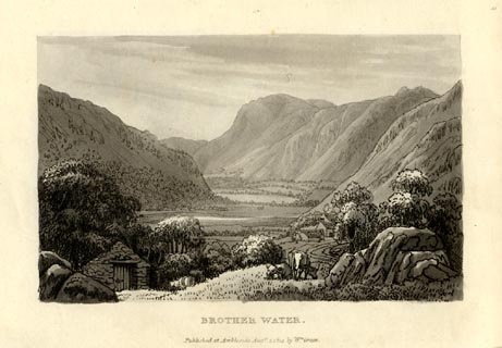 click to enlarge click to enlargeGN1048.jpg Plate 48 in Sixty Small Prints. printed at top right:- "48" printed at bottom:- "BROTHER WATER. / Published at Ambleside Augst. 1, 1814, by Wm. Green." item:- Armitt Library : A6653.48 Image © see bottom of page |
|
|
|
||
| evidence:- | old print:- Farington 1816 placename:- Place Fell |
|
| source data:- | Print, uncoloured engraving and descriptive text, The Head of Ulswater from Gobarrow
Park, Westmorland and Cumberland, drawn by Joseph Farington, engraved by F R Hay,
published by T Cadell and W Davies, Strand, London, 1815.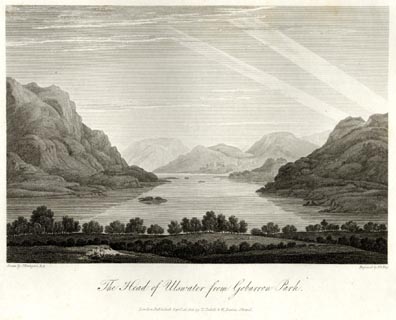 click to enlarge click to enlargeFA0409.jpg printed, bottom left, right, centre "Drawn by J. Farington R.A. / Engraved by F. R. Hay. / The Head of Ulswater from Gobarrow Park. / London Published Septr. 15, 1815, by T. Cadell &W. Davies, Strand." Descriptive text:- "... The dark and rugged mountain, on the left of our engraving, is Place Fell. ..." item:- Armitt Library : A6666.9 Image © see bottom of page |
|
|
|
||
| evidence:- | old map:- Otley 1818 placename:- Place Fell |
|
| source data:- | Map, uncoloured engraving, The District of the Lakes,
Cumberland, Westmorland, and Lancashire, scale about 4 miles to
1 inch, by Jonathan Otley, 1818, engraved by J and G Menzies,
Edinburgh, Scotland, published by Jonathan Otley, Keswick,
Cumberland, et al, 1833. OT02NY41.jpg item:- JandMN : 48.1 Image © see bottom of page |
|
|
|
||
| evidence:- | outline view:- Otley 1823 (4th edn 1830) placename:- Place Fell |
|
| source data:- | Print, engraving, outline view, The Mountains of Ullswater as seen from Pooley Bridge,
published by Jonathan Otley, Keswick, Cumberland et al, 1830.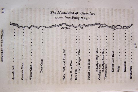 click to enlarge click to enlargeO75E05.jpg p.109 in A Concise Description of the English Lakes, by Jonathan Otley, 4th edition, 1830. "The Mountains of Ulswater: / as seen from Pooley Bridge." "Swarth Fell / Cawdale Moor / Winter Crag / Dove Crags / Hallen Fell, and Place Fell / Stone Cross Pike / Birk Fell / Dolly Waggon Pike / Nether Cove Head / Helvellyn High Man / Catchety Cam / Helvellyn Low Man / Herring Pike / Keppel Cove Head / Raise / Greenside / Gowbarrow" item:- Armitt Library : A1175.5 Image © see bottom of page |
|
|
|
||
| evidence:- | outline view:- Otley 1823 (4th edn 1830) placename:- Place Fell |
|
| source data:- | Print, engraving, outline view, Mountains of Patterdale as seen from the Slate Quarry
on Place Fell, published by Jonathan Otley, Keswick, Cumberland et al, 1830.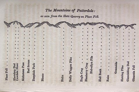 click to enlarge click to enlargeO75E10.jpg p.137 in A Concise Description of the English Lakes, by Jonathan Otley, 4th edition, 1830. "The Mountains of Patterdale: / as seen from the Slate Quarry on Place Fell." "Place Fell / Hartshop Dod / Cawdale Moor / Kirkstone Pass / Red Screes / Deepdale Park / Blease / Birks / Dolly Waggon Pike / Eagle Crag / Bleaberry Pike / Helvellyn Pile / Hall Bank / Raise / Greenside / Herring Pike / Glenridding Dod / Glencoin Fell" item:- Armitt Library : A1175.10 Image © see bottom of page |
|
|
|
||
| evidence:- | outline view:- Otley 1823 (8th edn 1849) placename:- Place Fell |
|
| source data:- | Engraving, outline view of mountains, Ullswater from Pooley Bridge, drawn by T Binns,
engraved by O Jewitt, opposite p.12 of A Descriptive Guide of the English Lakes, by
Jonathan Otley, 8th edition, 1849.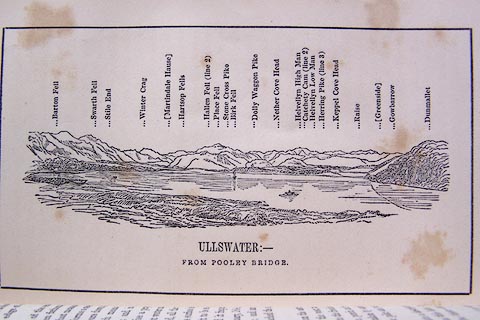 click to enlarge click to enlargeO80E07.jpg item:- Armitt Library : A1180.8 Image © see bottom of page |
|
|
|
||
| evidence:- | outline view:- Otley 1823 (8th edn 1849) placename:- Place Fell |
|
| source data:- | Engraving, outline view of mountains, Mountains of Patterdale from the Slate Quarry
on Place Fell, drawn by T Binns, engraved by O Jewitt, opposite p.14 of A Descriptive
Guide of the English Lakes, by Jonathan Otley, 8th edition, 1849.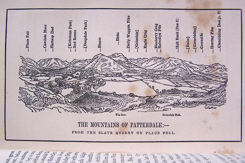 click to enlarge click to enlargeO80E08.jpg item:- Armitt Library : A1180.9 Image © see bottom of page |
|
|
|
||
| evidence:- | outline view:- Otley 1823 (5th edn 1834) |
|
| source data:- | Print, woodcut outline view, The Mountains of Patterdale, by
Jonathan Otley, Keswick, Cumberland, 1830.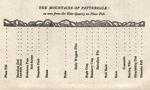 click to enlarge click to enlargeOT2E02.jpg Printed on p.11 of A Concise Description of the English Lakes, by Jonathan Otley, 5th edition, 1834. "THE MOUNTAINS OF PATTERDALE: as seen from the Slate Quarry on Place Fell." "Place Fell / Hartsop Dod / Cawdale Moor / Kirkstone Pass / Red Screes / Deepdale Park / Blease / Birks / Dolly Waggon Pike / Eagle Crag / Bleaberry Crag / Helvellyn Pile / Hall Bank / Raise / Greenside / Herring Pike / Glenridding Dod / Glencoin Fell" item:- JandMN : 48.3 Image © see bottom of page |
|
|
|
||
| evidence:- | outline view:- Otley 1823 (5th edn 1834) |
|
| source data:- | Print, woodcut outline view, Mountains of Ullswater, by
Jonathan Otley, Keswick, Cumberland, 1830.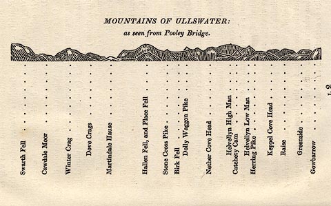 click to enlarge click to enlargeOT2E12.jpg Printed on p.113 of A Concise Description of the English Lakes, by Jonathan Otley, 5th edition, 1834. "MOUNTAINS OF ULLSWATER: as seen from Pooley Bridge." Mountains are listed:- "Swarth Fell / Cawdale Moor / Winter Crag / Dove Crags / Martindale Hause / Hallen Fell, and Place Fell / Stone Cross Pike / Birk Fell / Dolly Waggon Pike / Nether Cove Head / Helvellyn High Man / Catchety Cam / Helvellyn Low Man / Herring Pike / Keppel Cove Head / Raise / Greenside / Gowbarrow" item:- JandMN : 48.13 Image © see bottom of page |
|
|
|
||
| evidence:- | old map:- Garnett 1850s-60s H placename:- Place Fell |
|
| source data:- | Map of the English Lakes, in Cumberland, Westmorland and
Lancashire, scale about 3.5 miles to 1 inch, published by John
Garnett, Windermere, Westmorland, 1850s-60s.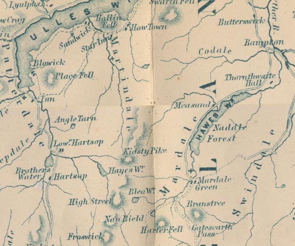 GAR2NY41.jpg "Place Fell" hill hachuring item:- JandMN : 82.1 Image © see bottom of page |
|
|
|
||
| evidence:- | old text:- Martineau 1855 |
|
| source data:- | Guide book, A Complete Guide to the English Lakes, by Harriet
Martineau, published by John Garnett, Windermere, Westmorland,
and by Whittaker and Co, London, 1855; published 1855-76. goto source Page 37:- "... closing in the whole [view from Kirkstone Pass] in front, the mass of Place Fell,- the other side of which goes sheer down into Ullswater." |
|
|
|
||
| evidence:- | outline view:- Martineau 1855 |
|
| source data:- | Print, engraving, outline view, Mountains seen on the Keswick Road approaching Ullswater,
drawn by L Aspland, engraved by W Banks, Edinburgh, published by John Garnett, Windermere,
Westmorland, and by Whittaker and Co, London, 1855.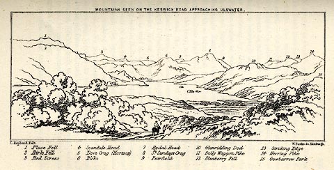 click to enlarge click to enlargeMNU115.jpg Opposite p.104 in A Complete Guide to the English Lakes, by Harriet Martineau. "MOUNTAINS SEEN ON THE KESWICK ROAD APPROACHING ULLSWATER." "L Aspland Delt. / W Banks Sc Edinr." The view is captioned, numbers referring to mountains in the image:- "1 Place Fell, 2 Birk Fell, 3 Red Screes, 4 Scandale Head, 5 Dove Crag (Hartsop), 6 Birks, 7 Rydal Head, 8 St. Sundays Crag, 9, Fairfield, 10 Glenridding Dod, 11 Dolly Waggon Pike, 12 Bleaberry Fell, 13 Striding Edge, 14 Herring Pike, 15 Gowbarrow Park." item:- Armitt Library : A1159.15 Image © see bottom of page |
|
|
|
||
| evidence:- | outline view:- Black 1856 (23rd edn 1900) placename:- Place Fell |
|
| source data:- | Print, lithograph, Outline Views, Ullswater - Mountains as seen a little on the Matterdale
Road near Lyulph's Tower on Ullswater, and Mountains as seen at the Slate Quarry at
Blowick on Ullswater, by J Flintoft, Keswick, Cumberland, engraved by R Mason, Edinburgh,
Lothian, about 1900.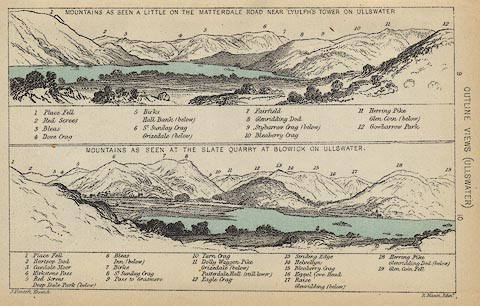 click to enlarge click to enlargeBC08E2.jpg "... 1 Place Fell ... 1 Place Fell ..." item:- JandMN : 37.8 Image © see bottom of page |
|
|
|
||
| evidence:- | outline view:- Black 1841 (3rd edn 1846) placename:- Place Fell |
|
| source data:- | Print, engraving, outline view, Mountains as seen a little on the Matterdale Road
near Lyulph's Tower on Ulleswater, and Mountains as seen at the Slate Quarry at Blowick
on Ulleswater, by J Flintoft, Keswick, Cumberland, engraved by R Mason, Edinburgh,
Lothian, about 1846.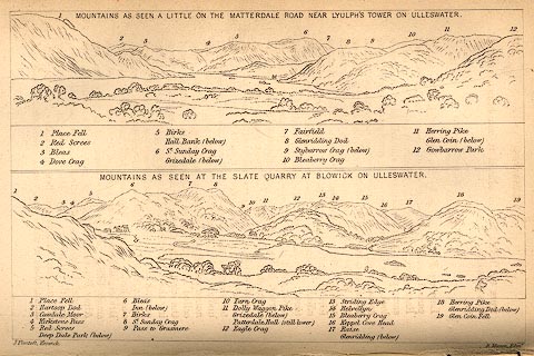 click to enlarge click to enlargeBC02E9.jpg "... 1 Place Fell ... 1 Place Fell ..." item:- JandMN : 32.15 Image © see bottom of page |
|
|
|
||
| evidence:- | outline view:- Tattersall 1836 placename:- Place Fell |
|
| source data:- | Print, engraving, Lower Reach, Ullswater, from Pooley Bridge, Cumberland, drawn by
George Tattersall, engraved by W F Topham, published by Sherwood and Co, Paternoster
Row, London, about 1836.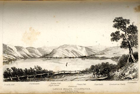 click to enlarge click to enlargeTAT140.jpg The print is captioned with mountain names and acts as an outline view. Tipped in opposite p.114 of The Lakes of England, by George Tattersall. printed at bottom:- "LOWER REACH, ULLSWATER, / from Pooley Bridge. / [London Pubd. ...]" printed at bottom left to right:- "Swarth Fell. / Martindale. / High Street. / Hallen Fell. / Kirkstone. / Place Fell. / Fairfield. / Gowbarrow Parks. / Dunmallet." item:- Armitt Library : A1204.41 Image © see bottom of page |
|
|
|
||
| evidence:- | outline view:- placename:- Place Fell |
|
| source data:- | Print, hand coloured engraving, Lower Reach, Ullswater from Pooley Bridge, Westmorland
and Cumberland, published by Sherwood and Co, London, 1836?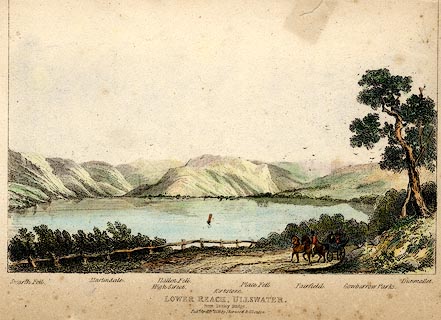 click to enlarge click to enlargePR0371.jpg Objects in the view are identified by a caption at the bottom - Swarth Fell, Martindale, High Street, Hallen Fell, Kirkstone, Place Fell, Fairfield, Gowbarrow Parks, Dumallet. printed at bottom:- "LOWER REACH, ULLSWATER. / from Pooley Bridge. / Pubd. April 15th 1836 by Sherwood &Co London." item:- Dove Cottage : 2008.107.371 Image © see bottom of page |
|
|
|
||
| evidence:- | old print:- |
|
| source data:- | Print, uncoloured engraving, Ulleswater, Westmoreland, drawn by Craig, engraved by
Hay, published by R N Rose, 45 Holborn Hill, London, 1820.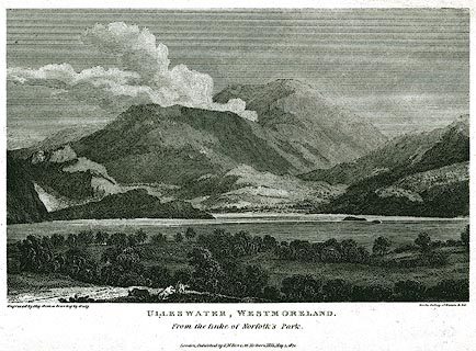 click to enlarge click to enlargePR0362.jpg Included in the Gallery of Nature and Art. printed at bottom left, right, centre:- "Engraved by Hay from a Drawing by Craig / for the Gallery of Nature &Art / ULLESWATER, WESTMORELAND. / From the Duke of Norfolk's Park. / London, Published by R. N. Rose, 45 Holborn Hill, May 1, 1820." item:- Dove Cottage : 2008.107.362 Image © see bottom of page |
|
|
|
||
 Click to enlarge CDM08.jpg From Beda Fell. (taken 30.6.2015) 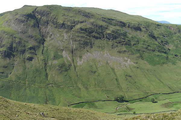 CDM09.jpg From Beda Fell. (taken 30.6.2015) 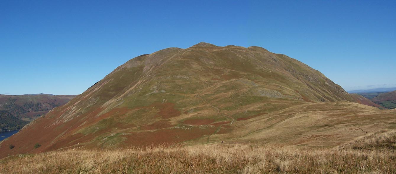 Click to enlarge BTS62.jpg (taken 20.10.2010)  BMY07.jpg (taken 2.11.2006) 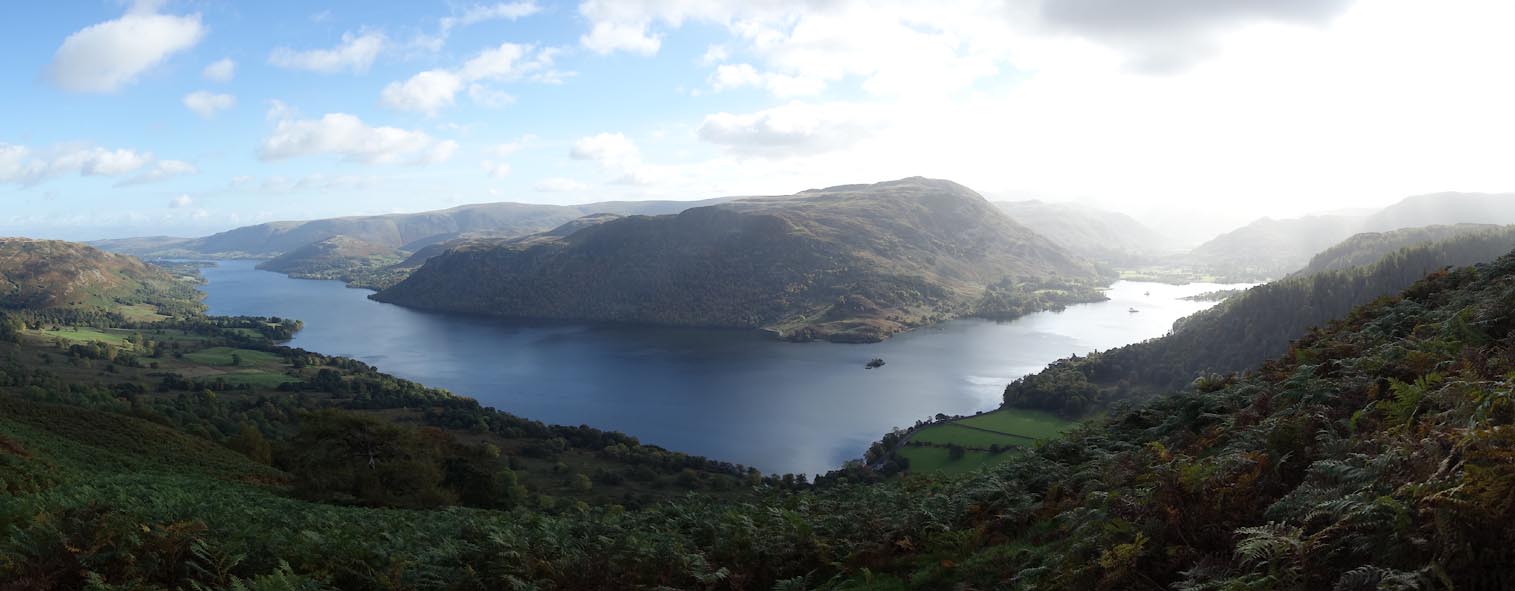 Click to enlarge CED62.jpg From Spying How. (taken 20.10.2015) 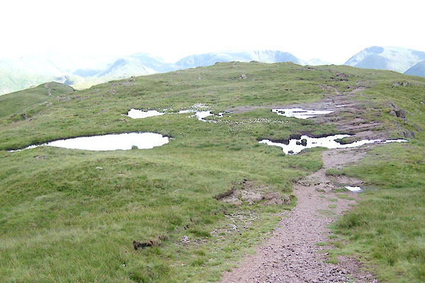 BRA01.jpg Unnamed tarns on the top. (taken 6.7.2009) |
||
|
|
||
Lakes Guides menu.