|
|
Frontispiece, map:-

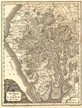
Map, The District of the Lakes, Cumberland,
Westmorland, and Lancashire north of the sands, now
Cumbria, scale about 4 miles to 1 inch, by Jonathan
Otley, Keswick, Cumberland, engraved by J and G
Menzies, Edinburgh, Lothian, Scotland, published by
Jonathan Otley, 1833.
Included in A Concise description of the English Lakes, by
Jonathan Otley, 5th edition, 1834. The map dates from
1817-18.
|