 Old Cumbria Gazetteer
 |
 |
|
| standing stone, Gatescarth | ||
| locality:- | Gatescarth Pass | |
| civil parish:- | Longsleddale (formerly Westmorland) | |
| civil parish:- | Shap Rural (formerly Westmorland) | |
| county:- | Cumbria | |
| locality type:- | standing stone | |
| locality type:- | stone | |
| coordinates:- | NY47380926 (?) | |
| 1Km square:- | NY4709 | |
| 10Km square:- | NY40 | |
|
|
||
| evidence:- | old map:- Hodgson 1828 placename:- Standing Stone |
|
| source data:- | Map, hand coloured engraving, 4 sheets mounted together on linen and rolled, Plan
of the County of Westmorland, scale about 1.25 inches to 1 mile, by Thomas Hodgson,
engraved by W R Gardner, Harpur Street, London, published by Thomas Hodgson, Lancaster,
and perhaps by C Smith, 172 Strand, London,1828.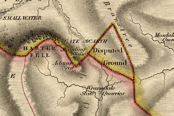 HDG6lsl5.jpg map courtesy of Mark Cropper "Standing Stone" item:- private collection : 371 Image © see bottom of page |
|
|
|
||
| notes:- |
A standing stone was recorded by Machell:- |
|
| "on the top of Gate Scarth" |
||
| : 2009: Archaeology Data Service &ADS Machell, T: 1691: Antiquary on Horseback, The |
||
|
|
||
 Lakes Guides menu.