 Old Cumbria Gazetteer
 |
 |
|
| North Lonsdale Crossing, Ulverston | ||
| North Lonsdale Crossing | ||
| Lonsdale Cross Station | ||
| site name:- | Conishead Priory branch railway | |
| locality:- | Sandside | |
| locality:- | Ulverston | |
| civil parish:- | Ulverston (formerly Lancashire) | |
| county:- | Cumbria | |
| locality type:- | level crossing | |
| locality type:- | railway station (halt?) | |
| coordinates:- | SD30647747 | |
| 1Km square:- | SD3077 | |
| 10Km square:- | SD37 | |
| SummaryText:- | Station or halt opened 1888; closed 1916. | |
|
|
||
| evidence:- | old map:- OS County Series (Lan 16 4) placename:- North Lonsdale Crossing item:- railway signal |
|
| source data:- | Maps, County Series maps of Great Britain, scales 6 and 25
inches to 1 mile, published by the Ordnance Survey, Southampton,
Hampshire, from about 1863 to 1948. OS County Series (Lan 16 8) 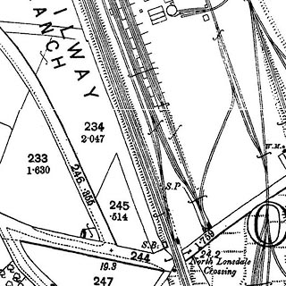 click to enlarge click to enlargeCSRY0151.jpg "North Lonsdale Crossing / S.B. / S.P." |
|
|
|
||
 Lakes Guides menu.